Ruchi (Glarus Alps)
| Ruchi | |
|---|---|
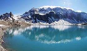 The west side of the Ruchi from Muttsee | |
| Highest point | |
| Elevation | 3,107 m (10,194 ft) |
| Prominence | 170 m (560 ft) [1] |
| Parent peak | Hausstock |
| Coordinates | 46°51′55″N 9°2′43″E / 46.86528°N 9.04528°ECoordinates: 46°51′55″N 9°2′43″E / 46.86528°N 9.04528°E |
| Geography | |
 Ruchi Location in Switzerland | |
| Location | Glarus/Graubünden, Switzerland |
| Parent range | Glarus Alps |
The Ruchi is a mountain in the Glarus Alps, located at an elevation of 3,107 m (10,194 ft) on the border between the Swiss cantons of Glarus and Graubünden. It overlooks the Muttsee (2,446 m or 8,025 ft) on its west side from where a trail leads to the summit. On its south-east side lies a small glacier, the Glatscher da Gavirolas. The Ruchi is connected to the higher summit of the Hausstock on the north-east by a 2 km (1.2 mi) long ridge.[2]
The nearest settlements are the villages of Linthal to the north, and Andiast to the south. Administratively, the mountain lies in the municipalities of Glarus Süd and Waltensburg/Vuorz.[2]
References
- ↑ Retrieved from the Swisstopo topographic maps. The key col is located north of the Chli Ruchi at 2,937 metres.
- 1 2 map.geo.admin.ch (Map). Swiss Confederation. Retrieved 2015-06-09.
External links
 Media related to Ruchi at Wikimedia Commons
- Ruchi on Hikr
- Ruchi on Peakbagger
This article is issued from Wikipedia - version of the 5/9/2016. The text is available under the Creative Commons Attribution/Share Alike but additional terms may apply for the media files.