Royal Oak Charter Township, Michigan
| Royal Oak Charter Township, Michigan | ||
|---|---|---|
| Charter township | ||
|
Royal Oak Charter Township Administrative Offices | ||
| ||
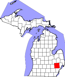
 Location of Royal Oak Charter Township within Oakland County, Michigan. | ||
 Royal Oak Charter Township, Michigan Location within the state of Michigan | ||
| Coordinates: 42°27′11″N 83°10′13″W / 42.45306°N 83.17028°WCoordinates: 42°27′11″N 83°10′13″W / 42.45306°N 83.17028°W | ||
| Country | United States | |
| State | Michigan | |
| County | Oakland | |
| Government | ||
| • Supervisor | Donna J. Squalls | |
| Area | ||
| • Charter township | 0.55 sq mi (1.4 km2) | |
| • Land | 0.55 sq mi (1.4 km2) | |
| • Water | 0 sq mi (0 km2) | |
| Elevation | 659 ft (201 m) | |
| Population (2010) | ||
| • Charter township | 2,419 | |
| • Density | 4,376.5/sq mi (1,689.8/km2) | |
| • Metro | 5,456,428 | |
| Time zone | EST (UTC-5) | |
| • Summer (DST) | EDT (UTC-4) | |
| ZIP codes | 48220 | |
| Area code(s) | 248 | |
| FIPS code | 26-70060[1] | |
| GNIS feature ID | 1627012[2] | |
| Website | royaloaktwp.com | |


Royal Oak Charter Township is a charter township of Oakland County of the U.S. state of Michigan. It is a suburb of Detroit. As of the 2010 census, the population was 2,419. The nearby city of Royal Oak is legally separate from the township.
Description

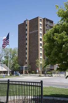
The city is roughly bound by Galaxie and North End avenues to the north, Myers Road to the west, 8 Mile Road to the south, and a line running north-south along the backyards of Mitchelledale Avenue to the east. The township is bisected by Wyoming Avenue and is a general mix of residential, commercial and industrial space. While mostly consisting of single-family homes, there are apartments along Fitzgerald Boulevard and Pasdena Avenue. Royal Oak Towers, an 11-story senior citizens apartment tower, is located off Wyoming Avenue. Commercial and retail space lines the southern border of the township along 8 Mile Road, while industrial space is located along the northern borders of the township.
Radio Plaza

At the northernmost point of the township lies Radio Plaza, which, bordered by Radio Plaza Street on the west, serves as home to Greater Media, and Salem Media Group's Detroit market headquarters, as well as Motower Multilink Corporation's 993 foot radio tower. WDTK, WLQV, WCSX, WMGC, and WRIF are all based out of Radio Plaza in Royal Oak Township.
History

Royal Oak Township was established in 1833 as a regular, 36-square-mile (93 km2) civil township, and at one time consisted of all or parts of the following modern cities and villages of Hazel Park, Ferndale, Oak Park, Madison Heights, Pleasant Ridge, Huntington Woods, Royal Oak, Berkley, and Clawson. The township began to shrink beginning in 1921 with the incorporation of the cities above. To provide greater protection from easy annexation, the township incorporated as a charter township in 1972.[3] Currently, the township has neither its own police department nor a post office. Its police department was disbanded in 1998. For public safety, the township contracts with the Michigan State Police for police services and the Ferndale Fire Department for fire services. For postal purposes, the community records its location as "Ferndale, MI 48220".
Until 2004, the township consisted of two small non-contiguous parcels of land within Oakland County. The larger portion was along Eight Mile Road, adjacent to Detroit, Oak Park, and Ferndale. A second portion, located northwest of the other portion, adjoining Oak Park and Southfield, was annexed by Oak Park on November 1, 2004.
Geography
According to the United States Census Bureau, the township has a total area of .55-square-mile (1.4 km2), all land.
Demographics

| Historical population | |||
|---|---|---|---|
| Census | Pop. | %± | |
| 1920 | 15,432 | — | |
| 1930 | 26,277 | 70.3% | |
| 1940 | 24,958 | −5.0% | |
| 1950 | 10,508 | −57.9% | |
| 1960 | 8,147 | −22.5% | |
| 1970 | 6,326 | −22.4% | |
| 1980 | 5,784 | −8.6% | |
| 1990 | 5,006 | −13.5% | |
| 2000 | 5,446 | 8.8% | |
| 2010 | 2,419 | −55.6% | |
| Est. 2014 | 2,462 | 1.8% | |
2010
As of the census[1] of 2010, there were 2,419 people residing in the township. The population density was 4,398.1 people per square mile (1,727.8/km²). There were 1,111 housing units at an average density of 2,020.0 per square mile (793.5/km²). The racial makeup of the township was 1.4% White, 95.3% African American, 0.1% Native American, 0.0% Asian, 0.0% Pacific Islander, 0.3% from other races, and 2.8% from two or more races. Hispanic or Latino of any race were 1.3% of the population.
2000
There were 1,211 households out of which 25.2% had children under the age of 18 living with them, 21.1% were married couples living together, 26.7% had a female householder with no husband present, and 48.5% were non-families. 44.1% of all households were made up of individuals and 17.2% had someone living alone who was 65 years of age or older. The average household size was 2.15 and the average family size was 3.02.
In the township the population was spread out with 25.0% under the age of 18, 10.1% from 18 to 24, 29.7% from 25 to 44, 18.3% from 45 to 64, and 16.9% who were 65 years of age or older. The median age was 34 years. For every 100 females there were 78.6 males. For every 100 females age 18 and over, there were 72.2 males.
The median income for a household in the township was $23,710, and the median income for a family was $28,397. Males had a median income of $28,824 versus $26,382 for females. The per capita income for the township was $15,027. About 19.9% of families and 23.5% of the population were below the poverty line, including 25.8% of those under age 18 and 30.4% of those age 65 and over.
Education
The township is divided between Oak Park School District and Ferndale Public Schools.[4]
References
- 1 2 "American FactFinder". United States Census Bureau. Retrieved 2008-01-31.
- ↑ U.S. Geological Survey Geographic Names Information System: Royal Oak Charter Township, Michigan
- ↑ Population Estimates Geographic Change Notes:
- ↑ "SCHOOL DISTRICT REFERENCE MAP (2010 CENSUS): Oakland County, MI" (Archive). U.S. Census Bureau. Retrieved on June 29, 2015.
External links
| Topics |  | |
|---|---|---|
| Detroit | ||
| Municipalities over 80,000 | ||
| Municipalities 40,000 to 80,000 | ||
| Cultural enclaves | ||
| Satellite cities | ||
| Counties in MSA | ||
| Counties in CSA | ||