New Jersey Route 21
| ||||
|---|---|---|---|---|
| McCarter Highway | ||||
 | ||||
| Route information | ||||
| Maintained by NJDOT | ||||
| Length: | 14.35 mi[1] (23.09 km) | |||
| Existed: | 1927 – present | |||
| Major junctions | ||||
| South end: |
| |||
|
| ||||
| North end: |
| |||
| Location | ||||
| Counties: | Essex, Passaic | |||
| Highway system | ||||
| ||||

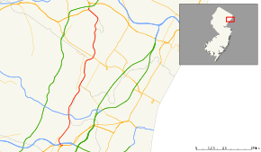
Route 21 is a highway in northern New Jersey, running 14.35 mi (23.09 km) from the Newark Airport Interchange with U.S. Route 1/9 and U.S. Route 22 in Newark, Essex County to an interchange with U.S. Route 46 in Clifton, Passaic County. The route is a four- to six-lane divided highway known as McCarter Highway on its southern portion in Newark that serves as a connector between the Newark and Paterson areas, following the west bank of the Passaic River for much of its length. It also serves as the main north–south highway through the central part of Newark, connecting attractions in downtown Newark with the Newark Liberty International Airport. The portion of Route 21 through Newark is a surface arterial that runs alongside the elevated Northeast Corridor rail line through the southern part of the city and continues north through Downtown Newark while the portion north of Downtown Newark is a freeway. Route 21 intersects many major roads including Interstate 78, Route 27, and Interstate 280 in Newark, Route 7 in Belleville, and Route 3 in Clifton.
Route 21 was created in 1927 to run from Newark to Belleville. In 1948, the route was extended north to Paterson. In the 1950s construction began on the freeway portion of Route 21 and it was completed in stages between Chester Avenue in Newark and Monroe Street in Passaic between 1958 and 1973. Plans were made to extend the freeway north to Interstate 80 in Elmwood Park; however, they were opposed by residents living on the east side of the Passaic River. In the 1980s, another northern extension of the Route 21 freeway was proposed to U.S. Route 46 in Clifton; this section was built between 1997 and 2000. The surface portion of Route 21 through Newark underwent many improvements in the 1990s and 2000s.
Route description
Essex County
Route 21 heads north from the Newark Airport Interchange with U.S. Route 1/9 and U.S. Route 22 in Newark near the Newark Liberty International Airport on the six-lane, divided McCarter Highway. This portion of Route 21 serves to connect Newark Liberty with downtown Newark.[2] The route interchanges with Interstate 78 and then crosses over the Northeast Corridor rail line on a viaduct, coming to an interchange with Broad Street that provides access to Route 27.[1][3] The route continues north, paralleling the elevated Northeast Corridor (former Pennsylvania Railroad) tracks that lead up to Newark Penn Station. At the Emmet Street intersection, Route 21 becomes a four-lane, undivided road and intersects Murray Street, which provides access to the Ironbound neighborhood of Newark. This section of Route 21 through the southern part of Newark has a high accident rate due to the heavy concentration of businesses and traffic lights along this portion of road.[4] The road widens to six lanes and the route intersects County Route 510 (Market Street) near Newark Penn Station and continues north into downtown Newark, splitting from the Northeast Corridor rail line.[1][3] It crosses Raymond Boulevard and the route meets County Route 508 (Center Street), with which it forms a concurrency.[1]
Route 21 and County Route 508 head along the west bank of the Passaic River, passing by the New Jersey Performing Arts Center. County Route 508 splits from Route 21 by heading east on Bridge Street, crossing the Passaic River, and Route 21 continues north, passing by Bears & Eagles Riverfront Stadium before interchanging with Interstate 280. The route intersects County Route 506 Spur (Clay Street). Past the intersection with 3rd Avenue, Route 21 becomes a six-lane freeway. After about a quarter mile, the northbound side swings under the southbound side and the freeway becomes a double-decker, passes by Mt. Pleasant Cemetery, and returns to single-decker configuration. It then interchanges with Chester Avenue/Riverside Avenue with a southbound exit and northbound entrance. Route 21 comes to a northbound exit and southbound entrance for Grafton Avenue and Mill Street; this interchange actually connects with the originally McCarter Highway, a street that retains this name and acts as a service road to Route 21 for a few blocks in this area. Route 21 briefly becomes a double-decker freeway again past the latter interchange, before crossing into Belleville at the Second River crossing.[1][3] The freeway features a southbound exit for Mill Street and a northbound exit for Route 7 and County Route 506 (Rutgers Street/Belleville Turnpike) as it passes by houses on the left side of the freeway. Route 21 features an interchange with Main Street that has a southbound exit and an entrance in both directions. It enters Nutley where the freeway interchanges with County Route 646 (Park Avenue), continuing north through residential areas along the Passaic River.[1][3]
Passaic County

Route 21 crosses into Clifton, Passaic County. It passes under Route 3 and comes to an interchange that provides access to that route. Past Route 3, the freeway comes to a northbound exit and southbound entrance for southbound County Route 624 (River Road), passing through residential neighborhoods, and enters Passaic. In Passaic, Route 21 interchanges with County Route 608 (Brook Avenue), County Route 614 (Van Houten Avenue), and County Route 624. The route features an interchange with County Route 624 (River Drive) and County Route 601 (Main Avenue) and meets State Street at a partial interchange with a northbound exit and southbound entrance. It provide access to the Union Avenue Bridge over the Passaic. Route 21 briefly enters Wallington, Bergen County before crossing back into Passaic, where it heads farther to the west of the Passaic River, passing through industrial and residential areas of Passaic. The freeway comes to an interchange that provides access to County Route 619 (Market Street), Dayton Avenue, and Monroe Street. Route 21 continues to the north and resumes along the west bank of the Passaic River, narrowing to four lanes and crossing back into Clifton. Upon entering Clifton, the route comes to an interchange with Ackerman Avenue. The freeway heads to the northwest, passing by a park and featuring a southbound exit and northbound entrance for Lexington Avenue before ending at an interchange with U.S. Route 46.[1][3]
History

Route 21 was first defined in the 1927 New Jersey state highway renumbering to run from Route 25 (now U.S. Route 1/9) and Route 29 (now U.S. Route 22) in Newark north to Belleville.[5][6] The surface portion of Route 21 in Newark, which follows the Northeast Corridor rail line, was commissioned in 1934 between Routes 25 and 29 and Market Street and the portion through downtown Newark was commissioned in 1936 between Market Street and Clay Street. In 1948, the Route 21 designation was extended north to Paterson.[7]
Plans for a freeway along the Route 21 corridor between Newark and Paterson date back to the early 1930s and became official in 1951.[8] In 1958, the highway was extended northward as a freeway along the west bank of the Passaic River to an interchange with Park Avenue in Nutley. Route 21 was extended to the Passaic Park interchange in 1962, Main Avenue in 1968, and Monroe Street in 1973. With the completion of the freeway, a portion of the former route was briefly known as Route 21A.[9]
The Route 21 freeway was planned to extend north to Interstate 80 in Elmwood Park at the interchange with County Route 507, crossing over the Passaic River. However, this extension was opposed by residents who lived on the east side of the Passaic River, and for a quarter-century, traffic headed for Paterson had to use local streets in Passaic. In the 1980s, plans were resurrected for completing the Route 21 freeway along the west bank of the Passaic River to U.S. Route 46 in Clifton. Official plans were made in 1996, and in late 1997, construction began on this portion of the freeway.[10][11] It opened on December 20, 2000 at a cost of $136 million.[12]
Sections of Route 21 through Newark were improved in the 1990s and the 2000s. The four-lane viaduct over the Northeast Corridor, which was built in the 1920s, was replaced between 1997 and 2003 at a cost of $253 million.[13] A major reconstruction is planned for the intersection with Interstate 280 at the William A. Stickel Memorial Bridge in Newark in 2015-2018.[14]
Major intersections
| County | Location | mi[1] | km | Exit | Destinations | Notes |
|---|---|---|---|---|---|---|
| Essex | Newark | 0.00 | 0.00 | Southbound exit and northbound entrance | ||
| 0.00 | 0.00 | Southbound exit and northbound entrance | ||||
| 0.22 | 0.35 | Southbound exit and northbound entrance | ||||
| 0.22 | 0.35 | Southbound exit and northbound entrance | ||||
| 0.76 | 1.22 | Broad Street | ||||
| 0.90 | 1.45 | North end of freeway section | ||||
| 1.10 | 1.77 | Murray Street — Ironbound Area | ||||
| 2.21 | 3.56 | |||||
| 2.55 | 4.10 | South end of CR 508 overlap | ||||
| 2.98 | 4.80 | North end of CR 508 overlap | ||||
| 3.20 | 5.15 | Interchange | ||||
| 3.37 | 5.42 | |||||
| 3.90 | 6.28 | South end of freeway section | ||||
| 4.62 | 7.44 | 4 | Chester Avenue / Riverside Avenue | Southbound exit and northbound entrance | ||
| 5.32 | 8.56 | 5 | Grafton Avenue / Mill Street — North Newark | Northbound exit and southbound entrance | ||
| Belleville | 5.83 | 9.38 | 5 | Mill Street — Belleville, North Newark | Southbound exit only | |
| 6.17 | 9.93 | 6 | Northbound exit only | |||
| 6.73 | 10.83 | 7 | Main Street — Belleville | No northbound exit | ||
| Nutley | 8.00 | 12.87 | 8 | Nutley, Lyndhurst (CR 646) | ||
| Passaic | Clifton | 9.28 | 14.93 | 9 | ||
| 9.94 | 16.00 | 10A | River Road south (CR 624) – Clifton | Northbound exit and southbound entrance | ||
| Passaic | 10.39 | 16.72 | 10B | Passaic Park, Clifton, Rutherford (CR 608 / CR 614 / CR 624) | Signed as exit 10 southbound | |
| 11.27 | 18.14 | 11A | River Drive (CR 624) / Main Avenue (CR 601) – Passaic | Signed as exit 11 southbound | ||
| 11.74 | 18.89 | 11B | State Street — Passaic | Northbound exit and southbound entrance | ||
| 12.60 | 20.28 | 12 | Market Street (CR 619) / Dayton Avenue / Monroe Street – Passaic | |||
| Clifton | 13.52 | 21.76 | 13 | Ackerman Avenue / Randolph Avenue — Botany Village, Garfield | ||
| 14.16 | 22.79 | 14 | Lexington Avenue | Southbound exit and northbound entrance | ||
| 14.35 | 23.09 | Northbound exit and southbound entrance | ||||
1.000 mi = 1.609 km; 1.000 km = 0.621 mi
| ||||||
See also
 U.S. Roads portal
 New Jersey portal
References
- 1 2 3 4 5 6 7 8 "Route 21 straight line diagram" (PDF). New Jersey Department of Transportation. Retrieved 2008-12-04.
- ↑ "NJ Route 21 reconstruction.(Special Report: Transportation)". HighBeam Research. Retrieved 2008-12-07.
- 1 2 3 4 5 Google (2008-12-05). "overview of New Jersey Route 21" (Map). Google Maps. Google. Retrieved 2008-12-05.
- ↑ "Route 21 Newark Needs Analysis" (PDF). New Jersey Department of Transportation. Retrieved 2008-12-07.
- ↑ State of New Jersey, Laws of 1927, Chapter 319.
- ↑ 1927 New Jersey Road Map (Map). State of New Jersey. Retrieved 2008-10-08.
- ↑ State of New Jersey, Laws of 1948, Chapter 235.
- ↑ Passaic County Master Plan. Passaic County, New Jersey. 1951.
- ↑ Waggoner, Walter H. (July 15, 1973). "Fiscal Plan To Revivify Newark Offered". The New York Times.
- ↑ Route 21 Freeway Extension Project: Administrative Action Final Environmental Impact Statement and Section 4(f) Statement,. Federal Highway Administration and New Jersey Department of Transportation. 1996.
- ↑ Fitzgerald, Thomas J. and Maia Davis (June 22, 1997). "Route 21 Completion Near". The Bergen Record.
- ↑ Page, Jeffrey (December 21, 2000). "Missing Link Is Finished After 28 Years". The Bergen Record.
- ↑ "Lettiere, Lautenberg cut ribbon on final phase of Route 21 Viaduct Project". New Jersey Department of Transportation. September 15, 2003. Retrieved 2012-04-06.
- ↑ "Route 280, Route 21 Interchange Improvements Project". New Jersey Department of Transportation. Retrieved September 30, 2015.
External links
| Wikimedia Commons has media related to New Jersey Route 21. |