Roundton Hill
| Roundton Hill | |
|---|---|
|
Roundton Hill viewed from the northeast | |
| Location | Church Stoke, Powys |
| Coordinates | 52°32′53″N 3°02′34″W / 52.54806°N 3.04278°WCoordinates: 52°32′53″N 3°02′34″W / 52.54806°N 3.04278°W |
| Operated by | Montgomeryshire Wildlife Trust |
| Status | SSSI |
| Website |
www |
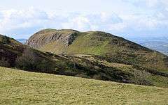
Roundton Hill is a rounded, steep sided, 1,210 feet (370 m) hill,[1] volcanic in origin,[1] in the easternmost part of old Montgomeryshire, Wales, which juts into the English border near Church Stoke.[2] It is managed as a nature reserve by the Montgomeryshire Wildlife Trust,[3] who acquired it in 1985.[1]
There was once an Iron Age hillfort here.[3] The vantage point offers views across the surrounding countryside. Lead and barite mines run into the hill,[3] and are today used as a roost by Horseshoe and Daubenton's bats.[3] Having avoided the plough, the hill's steep rocky slopes still support plants such as the mountain pansy, which has long since disappeared from most of the hills in mid-Wales. The reserve was made a Site of Special Scientific Interest (SSSI) in 1986.[1]
See also
References
- 1 2 3 4 "Roundton Hill". Mid-Wales Tourism. Retrieved 29 May 2011.
- ↑ "BBC - Breathing Places Event Finder - Roundton Hill - Montgomeryshire Wildlife Trust". BBC. Retrieved 29 May 2011.
- 1 2 3 4 "Roundton Hill". Montgomeryshire Wildlife Trust. Retrieved 29 May 2011.