Rouge River (Ontario)
| Rouge River (Katabokokonk) | |
| River | |
 Rouge River at Kirkhams Road, Toronto | |
| Country | Canada |
|---|---|
| Province | Ontario |
| Region | Greater Toronto Area |
| Municipalities | Toronto, Pickering, Markham, Richmond Hill |
| Part of | Great Lakes Basin |
| Tributaries | |
| - left | Little Rouge River |
| - right | Little Rouge Creek, Katabokokonk Creek, Bruce Creek, Beaver Creek |
| Source | |
| - location | Richmond Hill |
| - elevation | 286 m (938 ft) |
| - coordinates | 43°56′07″N 79°24′34″W / 43.93528°N 79.40944°W |
| Mouth | Lake Ontario |
| - location | West Rouge, Toronto |
| - elevation | 74 m (243 ft) |
| - coordinates | 43°47′41″N 79°06′55″W / 43.79472°N 79.11528°WCoordinates: 43°47′41″N 79°06′55″W / 43.79472°N 79.11528°W |
| Basin | 336 km2 (130 sq mi) |
| Discharge | |
| - average | 1.76 m3/s (62 cu ft/s) |
| - max | 5.98 m3/s (211 cu ft/s) |
| - min | 0.45 m3/s (16 cu ft/s) |
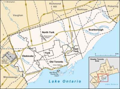 Location of the mouth of the Rouge River in Toronto, on the border with Pickering | |

The Rouge River is a river in Markham, Pickering, Richmond Hill and Toronto in the Greater Toronto Area of Ontario, Canada.[1] The river flows from the Oak Ridges Moraine to Lake Ontario at the eastern border of Toronto, and is the location of Rouge Park,[2] the only national park in Canada within a municipality. At its southern end, the Rouge River is the boundary between Toronto and southwestern Pickering in the Regional Municipality of Durham.
Course
The Rouge River begins in the Oak Ridges Moraine in Richmond Hill and flows past:
- Markham, northwest, central, to south, including a couple of conservation areas
- Eastern edge of Scarborough
- Rouge Valley Park
Watershed
The watershed of the Rouge River is located in the municipalities of Richmond Hill and Markham in the Regional Municipality of York; Pickering in the Regional Municipality of Durham; and Toronto. Tributaries of the Rouge River also extend into the municipalities of Aurora and Whitchurch-Stouffville in the Regional Municipality of York. The total area of the watershed is 336 square kilometres (130 sq mi), of which 40% is agricultural land, 35% urban, 24% forest/wetland/meadow and 1% watercourses/waterbodies.[3]
The headwaters of the Rouge River and its tributaries are found in the Oak Ridges Moraine. Water flows down from the elevated moraine to Lake Ontario.
It is one of a few wilderness areas left in South-Central Ontario, and has been virtually untouched by development since the arrival of Europeans. While many exclusive homes and conclaves border this area on the southern tip, it is currently surrounded largely by agricultural land. It is even devoid of recreational development but sports a considerable network of walking or bicycle paths. Unlike other rivers in the Toronto area, it is allowed to fill its entire flood plain on a regular basis rather than being forced through an artificial channel. However, parts of its watershed include the Toronto Zoo and the Beare Road Landfill.
Natural History
The Rouge River is part of the Carolinian life zone that is found in Southern Ontario.
In the early 19th century, pioneer settlers could spear large salmon spawning as far north as the upper tributaries of the Rouge in what is today Whitchurch-Stouffville [4]
History
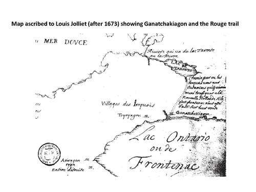
The river's name likely is French for red river' and based on the mappings by French explorer Louis Jolliet.
In the former city of Scarborough, the Rouge was the "third rail" issue of municipal politics, and many minor candidates for mayor often ran on a platform to preserve it. However, since Scarborough was annexed into the city of Toronto, Toronto City Council has voted on occasion to allow development around the river. For much of the course of the system in Toronto is still parkland or farmland.
As for the York Region sections, the southern watershed runs through residential development and lined with a few small parks. The source of the system is either natural or farmland.
Currently, there is a degree of abandonment in the area, of former farm lands, and historic houses. There also remains many historic houses which are still lived in, some even farmed. Research on Toronto's website listing its holdings of historic properties reveals over 20 historic buildings in the area, including Hillside PS, Scarborough's first schoolhouse, which sits across the street from a house built by the Pearse family in 1855.
Tributaries
- Little Rouge Creek (left) - runs northeast via Cedar Grove, Locust Hill, Dickson Hill, Ringwood, Lemonville, and Bloomington (Kennedy Road-Bethesda Road to Kingston Road and Altona Road)
- Katabokokonk Creek - a short creek runs in northeast Markham (west of Reesor Road and Don Cousens Parkway to Major Mackenzie Drive and west of Reesor Road) and bears the original First Nations name of the Rouge
- Morningside Creek (right) - flows from an area near Dennison Avenue and Markham Road to southwest of the Toronto Zoo and east of Morningside Road
- Exhibition Creek - runs from north of 16th Avenue and Highway 48 to Markham and Highway 7
- Robinson Creek (left)- runs from north of Elgin Mills between McCowan Road and Kennedy Road to the east end of Milne Park at 48 and Highway 7
- Eckardt Creek (left) runs from storm management ponds at west of The Bridle Walk and 16th Avenue north to Bur Oak Avenue and east of The Bridle Walk
- Bruce Creek (left) - starts in several ponds in the southeast corner of Aurora, flows briefly through the northeast corner of Richmond Hill, then southeast in the southwest corner of Whitchurch-Stouffville, through Bruce's Mill Conservation Area and into Markham. It flows through Angus Glen Golf Club and into Toogood Pond in Unionville, just before which the tributary Berczy Creek joins. The creek runs several hundred metres more to its mouth just east of Kennedy Road (Kennedy-Highway 7 to Woodbine Avenue north of Bloomington Road)
- Berczy Creek - runs from north of Stouffville Road and Woodbine Avenue into Bruce Creek just upstream of Toogood Pond
- Carleton Creek - runs from Woodbine Avenue and Major Mackenzie Drive to Berczy Creek at 16th Avenue and Warden Avenue
- Berczy Creek - runs from north of Stouffville Road and Woodbine Avenue into Bruce Creek just upstream of Toogood Pond
- Beaver Creek (right); flows from Richmond Hill to the future Downtown Markham development area; bounded by Major Mackenzie Drive-Bayview Avenue to Warden-Highway 407
- Apple Creek - a small creek branching off Beaver Creek near Highway 7 and Rodick Road and runs between residential developments in a northwest direction to 16th Avenue and Buttonfield Road (just south of Cachet Centre shopping mall)
Parks
- Bob Hunter Memorial Park
- Littles Road Park
- Morningview Ravine Park
- Woodlands Park
- Glen Rouge Park
- Rouge Valley Park, Markham
- Milne Park, Markham
- Apple Creek Park
- Cedar Valley Park
- Mount Joy Lake Park
- Springdale Park
- Monarch Park
- Ashton Meadows Park
- Artisan Park - Beaver Creek
- Beaver Greenway - Beaver Creek
- Bruce Creek Park
- Berczy Creek Park
- Boyton Woods Park
- Elgin Mills Cemetery
- Headwaters Park
Rouge Park
Rouge Park, the largest urban park in North America, includes significant portions of the Rouge River.
The Ministry of Stephen Harper proposed, in the 41st Canadian Parliament throne speech, the creation of a national park.[5]
Golf courses
- Parkview Golf Course - created from former IBM Canada Course
- Markham Green Golf Course - created from former IBM Canada Course (c. 1960) and Box Grove Golf Club (c. 1940); part of clubhouse became Rouge River Community Centre in the 1990s (pool added 1999)
- Cedar Brae Golf & Country Club (c. 1922)
- York Downs Golf and Country Club
- Angus Glen Golf Course - opened in 1992 built on the former Angus Glen Farm (c. 1957)
- Markham Golf Club
- Buttonville Fairways Golf Centre
Rouge Beach
The Rouge River meets Lake Ontario at Rouge Beach. At Rouge Beach, the Rouge Marsh is to the north and Lake Ontario to the south. More than half the remaining wetlands in the Greater Toronto Area are located here in the southern Rouge River.
See also
References
- ↑ "Rouge River". Geographical Names Data Base. Natural Resources Canada. Retrieved 2012-08-023. Check date values in:
|access-date=(help) - ↑ Rouge River Watershed - General Map (PDF) (Map). Toronto and Region Conservation Authority. October 2006. Retrieved 2012-08-03.
- ↑ "Rouge River Watershed Features". Toronto and Region Conservation Authority. Retrieved 2012-08-03.
- ↑ Boyle, David (1902). "On the paganism of the Iroquois of Ontario". Annual Archaeological Report 1901 - Appendix to the Report of the Minister of Education Ontario. Toronto: L.K. Cameron. p. 47.
- ↑ "Rouge Valley to become national park". CBC.ca. 2011-06-03. Retrieved 2011-06-03.
External links
| Wikimedia Commons has media related to Rouge Valley. |
- Rouge Park website
- Mandano Meriano, Hydrogeology of a complex glacial system, Rouge River-Highland Creek Watershed. Master of Science Thesis, University of Toronto, 1999.
- Toronto and Region Conservation Authority, Rouge River Watershed Plan, 2007.
| Features | |||||||
|---|---|---|---|---|---|---|---|
| History |
| ||||||
| Geography | |||||||
| Economy | |||||||
| Politics |
| ||||||
| Public services | |||||||
| Education | |||||||
| Culture |
| ||||||
| Transportation |
| ||||||
| |||||||
Great Lakes of North America | ||
|---|---|---|
| Main lakes |  | |
| Secondary lakes | ||
| Bays and Waterways |
| |
| Islands | ||
| Historic geology | ||
| Government | ||
| Related topics |
| |