Rotuma
| Rotuma Island Rotuma |
||
|---|---|---|
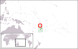 Location of Rotuma in Melanesia.
|
||
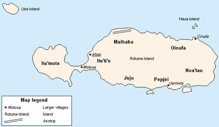 Schematic map of Rotuma indicating districts and main villages.
|
||
| Administrative center | Ahau 12°29.9′S 177°2.82′E / 12.4983°S 177.04700°E | |
| Official languages | ||
| Ethnic groups | ||
| Demonym | Rotuman | |
| Government | Dependency of Fiji | |
| • | Gagaj Pure (District officer) |
Niumaia Masere |
| • | Gagaj Jeaman (Council chairman) |
Tarterani Rigamoto |
| Independence from the United Kingdom as part of Fiji | ||
| • | Date | October 10, 1970 |
| Area | ||
| • | Total | 46 km2 18 sq mi |
| Population | ||
| • | 2007 census | 2,002 |
| Currency | Fiji dollar (FJD) | |
| Time zone | (UTC+12) | |
| Calling code | +679 | |
Rotuma is a Fijian dependency, consisting of Rotuma Island and nearby islets. The island group is home to a small but unique indigenous ethnic group which constitutes a recognisable minority within the population of Fiji, known as "Rotumans". Its population at the 2007 census was 2,002, although many more Rotumans live on mainland Fijian islands, totaling 10,000.
Geography and geology
These volcanic islands are located 646 kilometres (Suva to Ahau) north of Fiji. Rotuma Island itself is 13 kilometres long and 4 kilometres wide, with a land area of approximately 43 square kilometres, making it the 12th largest island of Fiji. The island is bisected into a larger eastern part, and a western peninsula, by a low narrow isthmus only 230 m wide, the location of Motusa village (Itu'ti'u district). North of the isthmus is Maka Bay, and in the south Hapmafau Bay. There are a large population of coral reefs in these bays, through which there are boat passages.
Rotuma is a shield volcano made of alkali-olivine basalt and hawaiite, with many small cones, and reaches 256 metres (840 ft) above sea level at Mount Suelhof near the center of the island. Satarua Peak, 166 meters high, lies near the eastern end of the island.[1] While very secluded from much of Fiji proper, the large reef and untouched beaches are renowned as some of the most beautiful in all of Fiji.
There are some islands located at a distance between 50 meters and 2 km from the main island, but still within the fringing reef:
- Solnoho (south)
- Solkope and Sari'i (southeast)
- 'Afgaha and Husia Rua (far southeast)
- Husia (Husiati'u) and Husiamea'me'a (close southeast)
- Hạuamea'me'a and Hạua (Hạuati'u) (close together northeast).
Additionally, there is a separate chain of islands between 3-6 kilometers northwest and west of the westernmost point of Rotuma Island. From northeast to southwest, are:
History
Linguistic evidence
Linguistic evidence suggests an original settlement from Fiji. Linguists include the Rotuman language in a subgroup with the languages of western Fiji, but Rotuman also has a large number of Polynesian loanwords, indicating later contact with Samoa and Tonga.
Origins in oral history
Rotuman oral history indicates that the islands' first inhabitants came from Samoa, whence they were led by a man named Raho. Shortly thereafter, further settlers arrived from Tonga. Later, additional settlers came from Tonga and Kiribati. In the 1850s and 1860s, Tongan Prince Ma'afu claimed Rotuma and sent subordinates to administer the main island and islets.[3]
Ratzel[4] wrote about a legend relating to the Samoans and Rotuma as follows:
"Thus the Samoans relate that one of their chiefs fished up Rotuma and planted coco-palm on it. But in a later migration the chief Tokaniua came that way with a canoe full of men and quarrelled with him about the prior right of possession."
European contact
The first known European sighting of Rotuma was in 1791, when Captain Edward Edwards and the crew of HMS Pandora landed in search of sailors who had disappeared following the Mutiny on the Bounty. There has been some argument whether the island discovered by Quirós known as Tuamaco fits the description and location of Rotuma, but no claim has been fully substantiated.
Mid-19th century
A favorite of whaling ships in need of reprovisioning, in the mid-nineteenth century Rotuma became a haven for runaway sailors, some of whom were escaped convicts. Some of these deserters married local women and contributed their genes to an already heterogeneous pool; others met violent ends, reportedly at one another's hands. Rotuma was visited as part of the United States Exploring Expedition in 1840.
Cession to Britain
Wesleyan missionaries from Tonga arrived on Rotuma in 1842, followed by Catholic Marists in 1847. Conflicts between the two groups, fuelled by previous political rivalries among the chiefs of Rotuma's seven districts, resulted in hostilities that led the local chiefs in 1879 to ask Britain to annex the island group. On 13 May 1881, Rotuma was officially ceded to the United Kingdom, seven years after Fiji became a colony. The event is annually celebrated as Rotuma Day.
Demographics
Although the island has been politically part of Fiji since 1881, Rotuman culture more closely resembles that of the Polynesian islands to the east, most noticeably Tonga, Samoa, Futuna, and Uvea. Because of their Polynesian appearance and distinctive language, Rotumans now constitute a recognizable minority group within the Republic of Fiji. The great majority of Rotumans (9,984 according to the 2007 Fiji census) now live elsewhere in Fiji, with 1,953 Rotumans remaining on Rotuma. Rotumans are culturally conservative and maintain their customs in the face of changes brought about by increased contact with the outside world. As recently as 1985, some 85 percent of Rotumans voted against opening the island up to tourism, wary of the influence of Western tourists. P&O Cruises landed on the island twice in the 1980s.
Prominent Rotumans and people of Rotuman descent
- The late Principal, Chief and Senator Aisea Aitu.
- Colonel Paul Manueli a former Commander of the Royal Fiji Military Forces, Fiji Cabinet minister, Senator and successful businessman.
- Field Marshal, Major General Jioji Konousi Konrote, a Cabinet Minister and former High Commissioner to Australia.
- Former Information Minister Marieta Rigamoto.
- Chief Justice Daniel Fatiaki.
- Irish sportsmen brothers Seán Óg and Setanta Ó hAilpín.
- NRL player John Sutton.
- Dr. Hiagi Wesley (Director of Jonathan Napela Center for Hawaiian and Pacific Islands Studies at Brigham Young University-Hawai'i).
- Professor Victor Narsimulu, Editor of Pacific Rim Journal/Associate Instructor: Pacific Islander-American Studies; University of Utah.
- Vilsoni Hereniko, playwright and film director.
- Sapeta Taito, actress (The Land Has Eyes).
- Rejieli Paulo, opera singer.
- Jono Gibbes (maternal side), a New Zealand rugby union player.
- Rocky Khan, New Zealand rugby union player[5]
- Graham Dewes, a Fiji rugby union player.
- Daniel Rae Costello, a Fijian-born Musician with Rotuman descent.
- Rebecca Tavo, Australian Touch Rugby Player with Rotuman father.[6]
- Selina Hornibrook, Former Australian Netball Player with Rotuman mother.
- Ngaire Fuata, New Zealand Television producer and singer with Rotuman father.[7]
- Pene Erenio, top Fiji soccer player. (Savusavu)
- Freddy Fesaitu, legendary Fijian reggae musician, leader of the Rootstrata band in the 1980s.
- Ravai Fatiaki Fiji Rugby Union Player
- Fred Fatiaki Coach FDPA
- Walter. G. Rigamoto, Former Supervisor of Elections and Ombudsman of Fiji
Politics and society
Rotuma was governed as an integral part of the Colony of Fiji after cession to the United Kingdom in 1881. Following Fiji's independence in 1970 and the military coups of 1987, Rotuma remained with Fiji.
Social organization
Rotuma is divided into seven autonomous districts, each with its own headman or chief (Gagaj 'es Itu'u), with villages:
- Noa'tau (extreme southeast): Fekeioko, Maragte'u, Faf'iasina, Matu'ea, 'Ut'utu, Kalvaka
- Oinafa (east): Oinafa, Lopta, Paptea
- Itu'ti'u (west, but east of western peninsula): Savlei, Lạu, Feavại, Tuạ'koi, Motusa, Hapmak, Losa, Fapufa, Ahạu (Government Station)
- Malha'a (north): Pepheua, 'Else'e, 'Elsio
- Juju (south): Tuại, Haga, Juju
- Pepjei (southeast): 'Ujia, Uạnheta, Avave
- Itu'muta (western peninsula): Maftoa, Lopo
The district chiefs and elected district representatives make up the Rotuma Island Council . The districts are divided into subgroupings of households (ho'aga) that function as work groups under the leadership of a subchief (gagaj 'es ho'aga). All district headmen and the majority of ho'aga headmen are titled. In addition, some men hold titles without headship (as tög), although they are expected to exercise leadership roles in support of the district headman. Titles, which are held for life, belong to specified house sites (fuạg ri). All the descendents of previous occupants of a fuạg ri have a right to participate in the selection of successors to titles.
On formal occasions titled men and dignitaries such as ministers and priests, government officials, and distinguished visitors occupy a place of honor. They are ceremonially served food from special baskets and kava. In the daily routine of Village life, however, they are not especially privileged. As yet no significant class distinctions based on wealth or control of resources have emerged, but investments in elaborate housing and motor vehicles by a few families have led to visible differences in standard of living.
Political organization
At the time of discovery by Europeans there were three pan-Rotuman political positions: the fakpure, the sạu, and the mua. The fakpure acted as convener and presiding officer over the council of district headmen and was responsible for appointing the sạu and ensuring that he was cared for properly. The fakpure was headman of the District that headed the alliance that had won the last war. The sạu's role was to take part in the ritual cycle, oriented toward ensuring prosperity, as an object of veneration. Early European visitors referred to the sạu as "king," but he actually had no secular power. The position of sạu was supposed to rotate between districts, and a breach of this custom was considered to be incitement to war. The role of mua is more obscure, but like the sạu, he was an active participant in the ritual cycle. According to some accounts the mua acted as a kind of high priest.
Following Christianization in the 1860s, the offices of sạu and mua were terminated. Colonial administration involved the appointment by the governor of Fiji of a Resident Commissioner (after 1935, a District Officer) to Rotuma. He was advised by a council composed of the district chiefs. In 1940 the council was expanded to include an elected representative from each district and the Assistant Medical Practitioner. Following Fiji's independence in 1970, the council assumed responsibility for the internal governance of Rotuma, with the District Officer assigned to an advisory role. Up until the first coup, Rotuma was represented in the Fiji legislature by a single senator.
Administratively, Rotuma is fully incorporated into Fiji, but with local government so tailored as to give the island a measure of autonomy greater than that enjoyed by other political subdivisions of Fiji. Rotuma has the status of a Dependency, and its administrative capital is 'Ahạu in the district of Itu'ti'u, where the "tariạgsạu" (traditionally the name of the sạu's palace) meeting house for the Council of Rotuma is based.
At the national level, Fijian citizens of Rotuman descent elect one representative to the Fijian House of Representatives, and the Council of Rotuma nominates one representative to the Fijian Senate. Rotuma is also represented in the influential Great Council of Chiefs by three representatives chosen by the Council of Rotuma. For electoral purposes, Rotumans were formerly classified as Fijians, but when the Constitution was revised in 1997-1998, they were granted separate representation at their own request. (The majority of seats in Fiji's House of Representatives are allocated on a communal basis to Fiji's various ethnic groups) In addition, Rotuma forms part (along with Taveuni and the Lau Islands) of the Lau Taveuni Rotuma Open Constituency, one of 25 constituencies whose representatives are chosen by universal suffrage.
Social control
The basis for social control is a strong socialization emphasis on social responsibility and a sensitivity to shaming. Gossip serves as a mechanism for sanctioning deviation, but the most powerful deterrent to antisocial behavior is an abiding belief in imminent justice, that supernatural forces (the 'atua or ghosts of ancestors) will punish wrongdoing. Rotumans are a rather gentle people; violence is extremely rare and serious crimes nearly nonexistent.
Conflict
Prior to cession, warfare, though conducted on a modest scale, was endemic in Rotuma. During the colonial era political rivalries were muted, since power was concentrated in the offices of Resident Commissioner and District Officer. Following Fiji's independence, however, interdistrict rivalries were again given expression, now in the form of Political contention. Following the second coup, when Fiji left the British Commonwealth of Nations, a segment of the Rotuman population, known as the "Mölmahao Clan" of Noa’tau rejected the council's decision to remain with the newly declared republic. Arguing that Rotuma had been ceded to the United Kingdom and not to Fiji, these rebels declared in 1987 independence of Republic of Rotuma and were charged with sedition. It did not have any substantive support, majority opinion appears to favor remaining with Fiji, but rumblings of discontent remain.
See also
References
- Islands of Fiji, Island Directory, United Nations Environment Programme
- ↑ http://permanent.access.gpo.gov/websites/pollux/pollux.nss.nima.mil/NAV_PUBS/SD/pub126/126sec03.pdf
- ↑ http://www.rotuma.net/os/lajereports/LRI2007turtlereport.pdf
- ↑ "The Rotuman People", p. 4, in Te'o Tuvale, An Account of Samoan History up to 1918
- ↑ The History of Mankind by Professor Friedrich Ratzel, Book II, Section A, The Races of Oceania page 173, MacMillan and Co., Ltd., published 1896
- ↑ Robson, Toby (30 January 2011). "Rocky Khan a sevens player with a difference". Fairfax Media. Retrieved 4 November 2013.
- ↑ http://www.rotuma.net/os/sports/sports2009/sports0901.htm
- ↑ http://tvnz.co.nz/view/tvone_minisite_story_skin/415110
- A.M. Hocart, Notes on Rotuman Grammar, Journal of the Royal Anthropological Institute, London, 1919, 252.
External links
- Rotuma website - an exhaustive website on all things Rotuman by anthropologists Alan Howard and Jan Rensel
- The Land Has Eyes - an award-winning film set in Rotuma made by Rotumans.
- Rotuman Hafa - Rotuman dance (see also Tautoga)
- Amateur radio - Amateur radio operations from Rotuma, with information on Rotuman history, culture, flora, fauna, geography, etc.; lengthy bibliography.
- General information, energy supply
- The Vertebrates of Rotuma and Surrounding Waters, by George R. Zug, Victor G. Springer, Jeffrey T. Wiliams and G. David Johnson, Atoll Research Bulletin, No. 316
Coordinates: 12°30′S 177°4.8′E / 12.500°S 177.0800°E