Roslyn, Washington
| Roslyn, Washington | |
|---|---|
| City | |
|
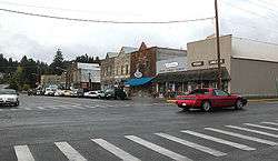
Downtown Roslyn | |
 Location of Roslyn, Washington | |
| Coordinates: 47°13′30″N 121°0′11″W / 47.22500°N 121.00306°WCoordinates: 47°13′30″N 121°0′11″W / 47.22500°N 121.00306°W | |
| Country | United States |
| State | Washington |
| County | Kittitas |
| Area[1] | |
| • Total | 4.37 sq mi (11.32 km2) |
| • Land | 4.37 sq mi (11.32 km2) |
| • Water | 0 sq mi (0 km2) |
| Elevation | 2,247 ft (685 m) |
| Population (2010)[2] | |
| • Total | 893 |
| • Estimate (2015)[3] | 903 |
| • Density | 204.3/sq mi (78.9/km2) |
| Time zone | Pacific (PST) (UTC-8) |
| • Summer (DST) | PDT (UTC-7) |
| ZIP code | 98941 |
| Area code(s) | 509 |
| FIPS code | 53-60055 |
| GNIS feature ID | 1525216[4] |
| Website | City of Roslyn |
Roslyn is a city in Kittitas County, Washington, United States. The population was 893 at the 2010 census.[5] Roslyn in located in the Cascade Mountains, about 80 miles east of Seattle.
The town was founded in 1886 as a coal mining company town. During the 20th century, the town gradually transitioned away from coal, and today its economy is primarily based on forestry and tourism. The town was the filming location for The Runner Stumbles, Northern Exposure, and The Man in the High Castle. Much of the town's history is preserved, and its downtown is designated a National Historic Landmark.
History

Early history
Coal deposits were first noted in the Roslyn area in 1883, with a large vein discovered at the upper Smith Creek canyon in 1885 by C.P. Brosious, Walter J. Reed, and Ignatius A. Navarre.[6] Roslyn was platted in 1886 by Logan M. Bullet, vice president of the Northern Pacific Coal Company The first commercial coal mining operations were begun to support railway operations.
Throughout the mid-1880s, the Northern Pacific Railway, the parent of Northern Pacific Coal Company, pushed from the east to reach Puget Sound across the Cascade Mountains. The Northern Pacific began building across Stampede Pass just west of Roslyn, approaching from Wallula in the east and Tacoma in the west. A 77-mile (124-km) gap remained in 1886. In January of that year, Nelson Bennett was given a contract to construct a 9,850 foot (3,002 m) tunnel under Stampede Pass, completing it in 1888. Roslyn, which lies on the route to Stampede Pass, provided the coal for the railway construction work as well as the continuing railroad operations.
Between 1886 and 1929, immigrant workers from countries such as Italy, Poland, Germany, Lithuania, Slovenia, Serbia and Croatia as well as from England, Ireland, Scotland and Wales came to work in the mines. These immigrants maintained the traditions of their homelands, as seen in the historic Roslyn Cemetery, with its 26 sections for distinct ethnic and lodge cemetery areas. Many Roslyn residents today are descendants of these immigrant miners.
Roslyn's peak coal mine production of nearly 2 million tons was reached in 1910. As coal-fired steam trains were being replaced by diesel power, the mines began to shut down in the 1920s. Although the local coal mines were far from played out (approximately 80% of the coal in the Roslyn mines remains unextracted), the last mine in the area closed in 1963 as business became unprofitable. With the loss of jobs, an exodus of residents ensued. In the mid-1970s, Roslyn began to flourish again as artists and others rehabilitated the town's houses and commercial buildings and settled there. Some individuals own second homes in Roslyn, while working and living full-time in Seattle or Tacoma, for instance.
As Roslyn was a "company town", life in the early years was centered around the production of coal. Most of the citizens of the town worked either for the Northern Pacific Coal Company or in one of the smaller businesses monopolized by the company, or were family members of someone who did. A hub of life in the town was the company store, now designated as a National Historic Landmark; it still stands at the corner of First Street and Pennsylvania Avenue.
Like many 19th-century American towns and cities, where risk of fires was high, Roslyn had a major fire in 1888, which destroyed most of its commercial district. Many buildings constructed after the fire used fire-resistant brick and sandstone. Some of these historic structures are still in use, including the 1889 Brick Tavern and the circa-1890 Fischer Building.
During its days of prosperity, the Northern Pacific Coal Company built the Roslyn Athletic Club for miners and their families. It was completed in 1902 and contained a gym, meeting rooms, and a bowling alley. Roslyn's public library, which was founded in 1898, moved into the Roslyn Athletic Club building in 1918. It continues to serve the community from this location.
Most of the town's 500 homes were built in the 1920s on land owned by the railroad. The 1920s-era commercial district consisted of four square blocks, of which about one dozen buildings remain as representatives of western frontier commercial architecture. Roslyn has many examples of Victorian elegance in its surviving buildings, as well as simple miner's shacks. The town of Roslyn was designated a National Historic Landmark in 1978. Recently, Roslyn became a Certified Local Government. Its Historic Preservation Commission restored the Roslyn Cafe, a local landmark.
Roslyn's railroad tracks have been removed and replaced by the Coal Mines Trail which runs from Cle Elum through Roslyn to Ronald. A walk on the trail affords visitors a look at the remains of Roslyn's mines and railroad depot site. The Roslyn Museum houses an extensive collection of photos and mining memorabilia, and features an exhibit on Roslyn's unique ethnic cemeteries.
Most recently, recreation and tourism have become the chief drivers of the economy. The business community has worked to bring in more visitors through annual festivals, including the Manly Man Festival in June, the Pioneer Days Picnic, and a Coal Mining Festival associated with Coal Mining History Week each August.
Knights of Labor Strike of 1888

Tensions between management and labor in the Roslyn mines began spilling over in the summer of 1888, when management laid off a number of labor union workers who were petitioning for higher wages. These layoffs led to a labor strike by the Knights of Labor, which shut down the mines.
Rather than work to reconcile with the demands of the strikers, the Northwest Coal Company, which conducted mining operations at Mine No. 3, a few miles away in nearby Ronald, recruited more than 300 black laborers as strikebreakers in Virginia, North Carolina, and Kentucky and transported them via special train across the continent to Roslyn. They represented the largest increase in the African-American population of Washington territory up until that time.
Forty-eight armed guards hired by the Northwest Coal Company escorted the first unit of 50 strikebreakers to Roslyn. The recruitment of these armed forces raised the interest of Governor Eugene Semple, who was unsettled at the prospect of such a large private militia operating within his territory.
Semple was weary of vigilanteism, having just negotiated a peaceful armistice to the Salmon Wars of 1887. The Salmon Wars were a series of disputes between Washington and Oregon settlers over fishing rights to the Columbia River. The battles between vigilante fisherman and the intervention of the territory’s militia in the incident exposed the danger of private armed forces, as well as inadequacies in the territory’s own official armed forces.
The Washington militia suffered from a lack of supplies, training, and a clear chain of command. Semple struggled with the militia throughout his time as territorial governor and at times was undermined by his own officers in matters as serious as troop deployments. As the militia was not designated as the official National Guard of Washington until January 1888, the armed forces available to Semple at the time of the Roslyn strikes were still poorly trained and poorly equipped.[7]
Semple ordered Sheriff Samuel T. Packwood to investigate the situation at Roslyn and to try to find a way in which the government could lawfully disarm the guards. Packwood arrested all 48 guards, along with the black strikebreakers, on trespassing charges. Packwood used trespassing charges because of an ongoing dispute between the Northwest Coal Company and settler Alexander Ross over the ownership of the land. The matter had been contentious since coal was discovered there three years earlier.
Once the prisoners were released to stand trial, they constructed a barricade of logs and barbed wire at the site of the mines. At this point Semple ordered a portion of the Washington militia to prepare to provide assistance at Roslyn. Semple tried to have the private guards arrested as vagrants, as they had no officially recognized occupation in the territory.
Eventually, the strike was settled and the African-American strikebreakers were assimilated into the community of Roslyn. In local archives, many photographs and first-hand accounts attest to the ethnic harmony in the community in the following decades. There was minimal racial segregation.
Mine accident of 1892
In 1892, 45 miners were killed in an explosion at Mine No. 4 near Roslyn, the deadliest mining accident in Washington history.
A local newspaper, The Cle Elum Echo, reported:
"The city of Roslyn is situated on land directly over the tunnel of Mine No. 4, and the shock caused by the explosion was not unlike an earthquake, shaking buildings in all parts of the city, while the burning, oil soaked timbers, vomited out of the shaft, were scattered in all directions, falling upon shingled roofs and causing over twenty roof fires, which were controlled by bucket brigades, all the city water and the fire department being concentrated upon the shaft and abutting frame structures, in spite of this all frame structures within two hundred feet of the shaft and tipple No. 4 were entirely destroyed."[8]
1892 "McCarty Gang" bank robbery
On September 24, 1892, a group of six bandits known as the McCarty Gang held up the Roslyn branch of the Ben Snipes Bank of Ellensburg. Three of the men stood guard with the horses while the other three went inside. One proceeded to empty the vault of an undisclosed amount of cash while the other two kept the bank employees in check, shooting the assistant teller in the hip as well as striking several bystanders on their way out. They made a clean getaway.[9]
The following day, several men from the group were seen at the Northern Pacific Railway depot in Cle Elum, where the money to meet the payroll for the Roslyn miners was transferred to the train to Roslyn. The sheriff was notified and formed a posse that confronted the bandits. A brief shoot-out occurred but the robbers managed to escape. It was unknown if any was injured. Several abandoned horses and a campsite were discovered by a search party, but they did not find the robbers. The entire gang was later turned in by the wife of one of the leaders. They were tried and released due to a hung jury.[9]
Several of the McCartys were later killed during an attempted bank robbery in Colorado.[9]
Roslyn's ethnic cemeteries

The Roslyn Cemetery is composed of 26 separate but adjacent cemetery plots, reflecting the diversity of early immigrant society. It was placed on the National Register of Historic Places in 1978. Clustered on 15 acres (61,000 m2) of woods and hills above the town's main street, the land was donated by or purchased from the Northern Pacific Company by fraternal, ethnic and civic organizations for burial of their deceased members.
The Independent Order of Odd Fellows (IOOF), Knights of Pythias Lodge, Soloka Lodge, Wanapum Tribe 28, Improved Order of Redmen, Cacciatori d’Africa (literally Hunters of Africa – an Italian lodge), Croatian Fraternal Union Lodge No. 56, SNF Lodge No. 79 (Croatian), St. Barbara Lodge No. 39 (Greek Catholic), and Dr. David Starcevich Lodge No. 56 (Croatian) are among the organizations and ethnicities represented at the cemetery. At least 24 nationalities are represented among the nearly 5,000 graves.
Post mining era
.jpg)
Although Roslyn clings to its coal mining and timber harvesting past, it has become a tourist and recreation destination. Tourism to the town received a boost when it was feature as the filming location for The Runner Stumbles and Northern Exposure. The town's proximity to Seattle makes it a popular destination for recreational travelers.
As many as 2,000 luxury homes are being developed nearby, potentially adding to the old town's population. Forests once owned and managed by Plum Creek Timber Company have been sold to two development companies, which are in the process of developing an extensive golf course community with houses and condominiums on the boundary of Roslyn. The new community is called Suncadia. As in similar small towns being transformed by large-scale capital projects and outside investment, these changes are expected to significantly improve Roslyn.[10]
Roslyn's railroad tracks have been removed and replaced by the Coal Mines Trail which runs from Cle Elum through Roslyn to Ronald. A walk on the trail affords visitors a look at the remains of Roslyn's mines and railroad depot site. The Roslyn Museum houses an extensive collection of photos and mining memorabilia, and features an exhibit on Roslyn's unique ethnic cemeteries.
Most recently, recreation and tourism have become the chief drivers of the economy. The business community has worked to bring in more visitors through annual festivals, including the Manly Man Festival in June, the Pioneer Days Picnic, and a Coal Mining Festival associated with Coal Mining History Week each August.
Featured in media
- The Runner Stumbles, a 1979 film starring Dick Van Dyke and Kathleen Quinlan, was filmed in Roslyn. Numerous local residents appeared in the movie as extras. Directed and produced by Stanley Kramer, the film was released by Twentieth Century Fox. Viewers of the film who have gone to Roslyn as tourists often stop at the Immaculate Conception Church, which was featured.
- Northern Exposure (1990–95), a hit CBS television series, filmed its exterior scenes for the fictional town of Cicely, Alaska, in Roslyn and the surrounding area. Featured in the opening title sequence are the Roslyn Cafe and a moose, the latter provided by Washington State University. Many local residents served as extras in the show, and some gained small parts. The Northern Exposure link is a tourist draw; many local stores use the show as a theme for their goods.
- In 2009, the band Bon Iver, with singer St. Vincent, wrote and recorded the song "Roslyn", named after the Washington town. The song was featured on the soundtrack to The Twilight Saga's second installment, the film New Moon.
- In 2014, the Amazon Studios's TV adaptation of Philip K. Dick’s novel The Man in the High Castle was filmed in Roslyn, which was represented as Canon City, Colorado in the series.[11]
Geography
Roslyn is located at 47°13′30″N 121°0′11″W / 47.22500°N 121.00306°W (47.225091, -121.002985).[12] It is 83.0 mi (133.6 km) – about 1 hour 25 mins - East-South-East from Seattle, Washington
According to the United States Census Bureau, the city has a total area of 4.37 square miles (11.32 km2), all of it land.[1]
Demographics
| Historical population | |||
|---|---|---|---|
| Census | Pop. | %± | |
| 1890 | 1,484 | — | |
| 1900 | 2,786 | 87.7% | |
| 1910 | 3,126 | 12.2% | |
| 1920 | 2,673 | −14.5% | |
| 1930 | 2,063 | −22.8% | |
| 1940 | 1,743 | −15.5% | |
| 1950 | 1,537 | −11.8% | |
| 1960 | 1,283 | −16.5% | |
| 1970 | 1,031 | −19.6% | |
| 1980 | 938 | −9.0% | |
| 1990 | 869 | −7.4% | |
| 2000 | 1,017 | 17.0% | |
| 2010 | 893 | −12.2% | |
| Est. 2015 | 903 | [13] | 1.1% |
| U.S. Decennial Census[14] 2015 Estimate[3] | |||
2010 census
As of the census[2] of 2010, there were 893 people, 437 households, and 224 families residing in the city. The population density was 204.3 inhabitants per square mile (78.9/km2). There were 648 housing units at an average density of 148.3 per square mile (57.3/km2). The racial makeup of the city was 95.1% White, 0.4% African American, 1.1% Native American, 0.6% Asian, 0.1% from other races, and 2.7% from two or more races. Hispanic or Latino of any race were 2.7% of the population.
There were 437 households of which 22.2% had children under the age of 18 living with them, 39.8% were married couples living together, 8.5% had a female householder with no husband present, 3.0% had a male householder with no wife present, and 48.7% were non-families. 39.6% of all households were made up of individuals and 13.1% had someone living alone who was 65 years of age or older. The average household size was 2.04 and the average family size was 2.73.
The median age in the city was 43.2 years. 18.4% of residents were under the age of 18; 5.2% were between the ages of 18 and 24; 29.1% were from 25 to 44; 32.2% were from 45 to 64; and 15.1% were 65 years of age or older. The gender makeup of the city was 52.6% male and 47.4% female.
2000 census
As of the census of 2000, there were 1,017 people, 467 households, and 249 families residing in the city. The population density was 82.3/km² (213.0/sq mi).
There were 623 housing units at an average density of 130.5 per square mile (50.4/km²). The racial makeup of the city was 95.87% White, 0.79% African American, 1.38% Native American, 0.39% Pacific Islander, and 1.57% from two or more races. Hispanic or Latino of any race were 1.38% of the population. Identification as to ethnicity in 2000 was as follows: 17.9% were of German ancestry, 15.9% English, 10.3% Irish, 7.1% Norwegian, 6.6% American, 5.7% Croatian, 5.7% Scotch-Irish, and 5.1% Italian.
There were 467 households out of which 25.7% had children under the age of 18 living with them, 43.9% were married couples living together, 6.2% had a female householder with no husband present, and 46.5% were non-families. 37.9% of all households were made up of individuals and 18.2% had someone living alone who was 65 years of age or older. The average household size was 2.18 and the average family size was 2.89.
In the city the population was spread out with 21.9% under the age of 18, 6.5% from 18 to 24, 26.9% from 25 to 44, 26.6% from 45 to 64, and 18.0% who were 65 years of age or older. The median age was 42 years. For every 100 females there were 96.0 males. For every 100 females age 18 and over, there were 90.9 males.
The median income for a household in the city was $35,313, and the median income for a family was $45,179. Males had a median income of $32,379 versus $25,625 for females. The per capita income for the city was $18,412. About 8.2% of families and 12.6% of the population were below the poverty line, including 9.1% of those under age 18 and 15.5% of those age 65 or over.
Points of interest in Roslyn
- Old City Hall & Library – Badly damaged in the 2001 Nisqually earthquake, this important public building is on the National Register of Historic Places as the anchor building of the Roslyn Historic District. The City of Roslyn and the Friends of the Roslyn Library have collaborated to support its structural repair and renovation.
- Roslyn Museum – Located on Pennsylvania Avenue, the museum includes an excellent display of artifacts from Roslyn's glory days as a coal mining town.
- Historic Coal Mines – Visitors can go to the Roslyn municipal offices, located on the corner of Pennsylvania Avenue and First Street, for information on tours of the historic coal mines. No tours go inside the mines.
- Roslyn Sunday Market – Every Sunday from June through September, this outdoor farmer's market and craft fair is located on Pennsylvania Avenue, offering a selection of local fruits, vegetables, arts, crafts and locally produced specialty items.
- Immaculate Conception Church – Located on Idaho and "B" Streets overlooking Roslyn, this Roman Catholic church has a spire that is a notable landmark in the town. It was built in 1887 and continues to serve the local community with regular masses held every Sunday. The church was used for scenes in the 1979 film The Runner Stumbles.
- Storefront Studio – This yearly project is a collaboration between the Roslyn Downtown Association and the University of Washington's architectural department. Each year (usually April through May), numerous students come to work with commercial, civic and community clients on real, small-scale architectural, planning, public art, and landscape projects in the town. More information is available at the Roslyn Visitor Center.
- Coal Mines Trail – Originating in nearby Cle Elum, this hiking and recreational trail passes through Roslyn before ending in the town of Ronald. The trail follows the original Northern Pacific Railway line. Access is at the east end of Pennsylvania Avenue.
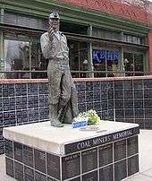
- Coal Miners' Memorial – Located across from the current city hall, this memorial statue commemorates those individuals who lost their lives in local coal mining.
- Cicely's Gift Shop- founded in 1989 by Marianne Milos Ojurovich, the store originally opened in a 9' x 11' former coal mine weight station building set in the back of an empty lot on 2nd street. In 1995 after the ending of the globally famous television show Northern Exposure, she relocated the store to its current location, the former set of Dr. Fleischmans office, which she kept as intact as possible. A must See when visiting Roslyn!
- The Brick Tavern – In 1889, John Buffo and Peter Giovanni opened a tavern in this location. The tavern was rebuilt in 1898 using 45,000 bricks and took the name "The Brick". It is billed as the oldest continuously operating tavern in the state of Washington.[15] The building was used for scenes of a fictional tavern of the same name in the 1990s television series Northern Exposure.
- Roslyn Cemetery – Divided into areas by lodge (Knights of Labor, Elks, IOOF, Red Men etc.) and by country of origin (Croatian, Italian, Polish, Slovak, etc.), the cemetery provides a historical perspective on Roslyn.
- Ronald, Washington – Approximately 2 miles west of Roslyn, this town was built over Mine No. 3, where Southern black miners were brought in 1892 to work as strikebreakers.
- Lake Cle Elum & Salmon La Sac – Lake Cle Elum is a popular year-round recreational destination for camping, hiking, cross-country skiing, snowmobiling, boating, and wilderness activities. Salmon La Sac is a natural area along the Cle Elum River used for kayak races, and it serves as an access point to the nearby wilderness and backcountry.
Further reading
- John C. Shideler (1986-06-01). Coal towns in the Cascades: a centennial history of Roslyn and Cle Elum, Washington. Melior Pubns. ISBN 978-0-9616441-0-9.
References
- 1 2 "US Gazetteer files 2010". United States Census Bureau. Retrieved 2012-12-19.
- 1 2 "American FactFinder". United States Census Bureau. Retrieved 2012-12-19.
- 1 2 "Population Estimates". United States Census Bureau. Retrieved July 13, 2016.
- ↑ "Roslyn". Geographic Names Information System. United States Geological Survey.
- ↑ "2010 Census Redistricting Data (Public Law 94-171) Summary File". American FactFinder. United States Census Bureau. Retrieved 20 September 2012.
- ↑ Majors, Harry M. (1975-11-01). Exploring Washington. Van Winkle Publishing Co. pp. 89–90. ISBN 978-0-918664-00-6.
- ↑ Welch, Jack. "Hot Work." Columbia: The Magazine of Northwest History Winter 2013-2014: 4-10. Print.
- ↑ "Explosion at Roslyn", The Cle Elum Echo, at Ellensburg Public Library Archived July 3, 2008, at the Wayback Machine.
- 1 2 3 Lyman, W.D. (1919). History of the Yakima Valley, Washington, Comprising Yakima, Kittitas and Benton Counties. The S.J. Clarke Publishing Co. pp. 762–777.
- ↑ The Economist, Volume 379, Number 8481, pp. 30-31, 10 June 2006
- ↑ Muir, Pat (5 Oct 2014). "Roslyn hopes new TV show brings 15 more minutes of fame". Yakima Herald. Retrieved 1 Nov 2014.
- ↑ "US Gazetteer files: 2010, 2000, and 1990". United States Census Bureau. 2011-02-12. Retrieved 2011-04-23.
- ↑ "Annual Estimates of the Resident Population for Incorporated Places: April 1, 2010 to July 1, 2015". Retrieved July 2, 2016.
- ↑ United States Census Bureau. "Census of Population and Housing". Retrieved July 21, 2014.
- ↑ The Brick Tavern claims the title of the oldest continuously operating tavern in the state of Washington, opening in 1889 and operating under a single name since 1898. According to its owners, the Bluebird Inn in Bickleton, Washington, is the state's oldest functioning tavern having first opened in 1882; however, it has operated under numerous names and has not been continuously licensed to operate since its founding.
External links
| Wikimedia Commons has media related to Roslyn, Washington. |
- City of Roslyn
- Roslyn Museum
- Roslyn Public Library
- Roslyn and the TV show, Northern Exposure, Curt Cass website
- "Roslyn's Black History collection", Group of 84 historic photographs dating from the late 19th century to the 1960s of African-American miners, settlers and residents of the coal mining community of Roslyn, Washington, at Central Washington University.
- Ellensburg History, 294 historic photographs dating from the late 19th century to the early 20th century, of Ellensburg and the other communities in Kittitas County, including Roslyn, at Central Washington University.
- "Roslyn Heritage", collection of historic photos and lectures, Roslyn Public Library.
Municipalities and communities of Kittitas County, Washington, United States | ||
|---|---|---|
| Cities | 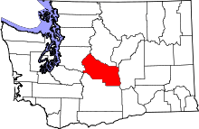 | |
| Town | ||
| CDPs | ||
| Unincorporated communities | ||
| Indian reservation | ||
| Ghost towns | ||
| Footnotes | ‡This populated place also has portions in an adjacent county or counties | |