Rosedale, Washington
| Rosedale, Washington | |
|---|---|
| CDP | |
 Rosedale, Washington | |
| Coordinates: 47°20′27″N 122°37′59″W / 47.34083°N 122.63306°WCoordinates: 47°20′27″N 122°37′59″W / 47.34083°N 122.63306°W | |
| Country |
|
| State |
|
| County | Pierce County, Washington |
| Area | |
| • Total | 12.0 km2 (4.6 sq mi) |
| Elevation | 146 m (479 ft) |
| Population (2010) | |
| • Total | 4,044 |
| • Density | 340/km2 (870/sq mi) |
| Time zone | Pacific |
| Area code(s) | 253 |
Rosedale is a CDP located in Pierce County, Washington.
A post office called Rosedale was established in 1887, and remained in operation until 1918.[1] The community was named for roses near the original town site.[2]
Demographics
In 2010, it had a population of 4,044 inhabitants. 1,478 are male. 2,566 are female.[3]
Geography
Rosedale is located at coordinates 47°20′27″N 122°37′59″W.
References
- ↑ "Post Offices". Jim Forte Postal History. Retrieved 22 August 2016.
- ↑ Meany, Edmond S. (1923). Origin of Washington geographic names. Seattle: University of Washington Press. p. 249.
- ↑ "Rosedale, Washington". Retrieved 20 August 2014.
Municipalities and communities of Pierce County, Washington, United States | ||
|---|---|---|
| Cities | 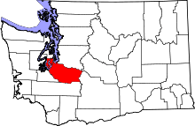 | |
| Towns | ||
| CDPs |
| |
| Other unincorporated communities | ||
| Indian reservation | ||
| Military bases | ||
| Ghost towns | ||
| Footnotes | ‡This populated place also has portions in an adjacent county or counties | |
This article is issued from Wikipedia - version of the 8/24/2016. The text is available under the Creative Commons Attribution/Share Alike but additional terms may apply for the media files.