Rose Hill, Fairfax County, Virginia
| Rose Hill, Fairfax County, Virginia | |
|---|---|
| Census-designated place | |
|
Rose Hill Shopping Center, August 2015 | |
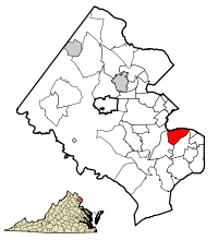 Location within Fairfax county | |
 Rose Hill  Rose Hill  Rose Hill Location within Fairfax county | |
| Coordinates: 38°47′21″N 77°6′32″W / 38.78917°N 77.10889°WCoordinates: 38°47′21″N 77°6′32″W / 38.78917°N 77.10889°W | |
| Country | United States |
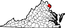
| State | Virginia |
| County | Fairfax |
| Area | |
| • Total | 5.57 sq mi (14.43 km2) |
| • Land | 5.56 sq mi (14.39 km2) |
| • Water | 0.02 sq mi (0.04 km2) |
| Elevation | 203 ft (62 m) |
| Population (2010) | |
| • Total | 20,226 |
| • Density | 3,640/sq mi (1,405.6/km2) |
| Time zone | Eastern (EST) (UTC-5) |
| • Summer (DST) | EDT (UTC-4) |
| FIPS code | 51-68880 |
| GNIS feature ID | 2389774 |

Rose Hill is a census-designated place (CDP) in Fairfax County, Virginia, United States. The population was 20,226 at the 2010 census.[1] Built in the mid-1950s, Rose Hill is the largest of the subdivisions that make up the CDP, which is just southwest of Alexandria; others include Wilton Woods, Burgundy Village, and Winslow Heights. Street addresses are in Alexandria ZIP codes 22310, 22303 and 22315.
Geography
Rose Hill is located in southeastern Fairfax County at 38°47′21″N 77°6′32″W / 38.78917°N 77.10889°W (38.789263, -77.108971).[2] It is bordered to the north by the city of Alexandria, to the east by Huntington, to the south by Groveton and Hayfield, to the southwest by Kingstowne, and to the west by Franconia. The CDP's borders follow the Capital Beltway and CSX rail line on the north, South Van Dorn Street and some smaller roads on the west, South Kings Highway on the south, and Shaffer Drive and Telegraph Road on the east.
According to the United States Census Bureau, the Rose Hill CDP has a total area of 5.57 square miles (14.43 km2), of which 0.02 square miles (0.04 km2), or 0.28%, is water.[1]
Demographics
As of the census[3] of 2000, there were 15,058 people, 5,683 households, and 4,080 families residing in the CDP. The population density was 3,273.7 people per square mile (1,263.9/km²). There were 5,783 housing units at an average density of 1,257.3/sq mi (485.4/km²). The racial makeup of the CDP was 73.52% White, 9.52% African American, 0.27% Native American, 8.48% Asian, 0.05% Pacific Islander, 4.40% from other races, and 3.75% from two or more races. Hispanic or Latino of any race were 10.65% of the population.
There were 5,683 households out of which 31.5% had children under the age of 18 living with them, 60.7% were married couples living together, 7.9% had a female householder with no husband present, and 28.2% were non-families. 21.0% of all households were made up of individuals and 5.3% had someone living alone who was 65 years of age or older. The average household size was 2.65 and the average family size was 3.09.
In the CDP the population was spread out with 22.7% under the age of 18, 5.7% from 18 to 24, 34.0% from 25 to 44, 27.3% from 45 to 64, and 10.3% who were 65 years of age or older. The median age was 38 years. For every 100 females there were 96.6 males. For every 100 females age 18 and over, there were 94.4 males.
The median income for a household in the CDP was $80,815, and the median income for a family was $89,414. Males had a median income of $53,917 versus $43,245 for females. The per capita income for the CDP was $34,213. About 1.6% of families and 3.6% of the population were below the poverty line, including 5.7% of those under age 18 and 3.1% of those age 65 or over.
| Historical population | |||
|---|---|---|---|
| Census | Pop. | %± | |
| 1970 | 14,692 | — | |
| 1980 | 11,962 | −18.6% | |
| 1990 | 12,675 | 6.0% | |
| 2000 | 15,058 | 18.8% | |
| 2010 | 20,226 | 34.3% | |
| source:[4] | |||
Education
Fairfax County Public Schools operates public schools.
Fairfax County Public Library operates the John Marshall Library in the CDP.[5][6]
References
- 1 2 "Geographic Identifiers: 2010 Demographic Profile Data (G001): Rose Hill CDP (Fairfax County), Virginia". U.S. Census Bureau, American Factfinder. Retrieved October 17, 2016.
- ↑ "US Gazetteer files: 2010, 2000, and 1990". United States Census Bureau. 2011-02-12. Retrieved 2011-04-23.
- ↑ "American FactFinder". United States Census Bureau. Retrieved 2008-01-31.
- ↑ "CENSUS OF POPULATION AND HOUSING (1790-2000)". U.S. Census Bureau. Retrieved 2010-07-17.
- ↑ "Library Branches." Fairfax County Public Library. Retrieved on October 21, 2009.
- ↑ "Rose Hill CDP, Virginia." U.S. Census Bureau. Retrieved on October 21, 2009.