Romulus, New York
| Romulus, New York | |
|---|---|
| Town | |
 Romulus, New York Location within the state of New York | |
| Coordinates: 42°43′19″N 76°50′26″W / 42.72194°N 76.84056°W | |
| Country | United States |
| State | New York |
| County | Seneca |
| Settled | 1789 |
| Established | March 5, 1794[1] |
| Government | |
| • Type | Town Council |
| • Supervisor | David Kaiser |
| • Clerk | Terry Rose Smith |
| • Court | Justice Donald Greule |
| Area | |
| • Total | 51.3 sq mi (132.9 km2) |
| • Land | 37.8 sq mi (97.9 km2) |
| • Water | 13.5 sq mi (35.0 km2) |
| Elevation | 758 ft (231 m) |
| Population (2010) | |
| • Total | 4,316 |
| • Density | 114.2/sq mi (44.1/km2) |
| Time zone | Eastern (EST) (UTC-5) |
| • Summer (DST) | EDT (UTC-4) |
| ZIP code | 14541 |
| Area code(s) | 315 and 607 |
| FIPS code | 36-63440 |
| GNIS feature ID | 0979431 |
| Website | http://www.romulustown.com/ |
Romulus is a town in Seneca County, New York, United States. The population was 4,316 at the 2010 census. The town is named after the mythical founder of Rome, Romulus, a name assigned by a clerk with an interest in the classics.
The Town of Romulus is in the central part of the county, northwest of Ithaca, New York.
The town has a hamlet (and census-designated place), also called Romulus. Government offices for the town are located in Willard.[2]
History
Before the American Revolution, this area was controlled by both the Cayuga and the Seneca nations of the Haudenosaunee (Iroquois). French Jesuit missionaries visited the area in the 17th Century. The Sullivan Expedition in 1779 destroyed native villages and drove many of the Native Americans away. Romulus contains the area of Kendaia (Apple Town), a former Iroquois (Seneca) village destroyed by the residents in anticipation of the arrival of the Sullivan Expedition on September 5, 1779.
After the war, this town became part of the Central New York Military Tract, land for veterans of the Revolution. Returning natives were provided with land at the north end of Cayuga Lake. This reservation was partly in the eastern side of modern Romulus. The first non-native settlers arrived around 1789.
The town was formed while still part of Onondaga County in 1794. In 1800, part of Romulus was used to make the Town of Fayette. The north part of Romulus was used to form the Town of Varick in 1830.
The town also contains the former Seneca Army Depot (1941 - 1990s), built during World War II and finally closed in 2001. It was a major employer for citizens of Romulus and surrounding parts of Seneca County. Seneca Army Airfield, located along N.Y. Route 96A, provided a long runway for transport aircraft.
Willard State Hospital was converted to a state prison drug treatment center in 1995.
The town is home to the Five Points Correctional Facility, a New York state maximum security prison for men.
(Portions of a diary written by Henry McLafferty Jr (1819–1859) are available online from the Rochester Public Library: Romulus Revisited: Extracts from the Diary of Henry McLafferty, Jr. 1856–1857).
Geography
The town lies between Cayuga Lake and Seneca Lake at latitude 42° 45' 8" N. and longitude 76° 50' 2" W. at an altitude of 705 ft (214 m).
According to the United States Census Bureau, the town has a total area of 51.3 square miles (133 km2), of which 37.8 square miles (98 km2) is land and 13.5 square miles (35 km2) (26.34%) is water.
Romulus is in the Finger Lakes District of New York and lies between Cayuga Lake and Seneca Lake.
New York State Route 89, New York State Route 96, New York State Route 96A, and New York State Route 414 are all north-south highways in the town.
Demographics
| Historical population | |||
|---|---|---|---|
| Census | Pop. | %± | |
| 1820 | 3,698 | — | |
| 1830 | 2,089 | −43.5% | |
| 1840 | 2,235 | 7.0% | |
| 1850 | 2,050 | −8.3% | |
| 1860 | 2,170 | 5.9% | |
| 1870 | 2,223 | 2.4% | |
| 1880 | 2,765 | 24.4% | |
| 1890 | 2,852 | 3.1% | |
| 1900 | 2,895 | 1.5% | |
| 1910 | 2,803 | −3.2% | |
| 1920 | 2,754 | −1.7% | |
| 1930 | 2,856 | 3.7% | |
| 1940 | 2,865 | 0.3% | |
| 1950 | 4,263 | 48.8% | |
| 1960 | 3,509 | −17.7% | |
| 1970 | 4,284 | 22.1% | |
| 1980 | 2,464 | −42.5% | |
| 1990 | 2,532 | 2.8% | |
| 2000 | 2,036 | −19.6% | |
| 2010 | 4,316 | 112.0% | |
| Est. 2014 | 4,353 | [3] | 0.9% |
As of the census[5] of 2010, there were 4,316 people, 821 households, and 576 families residing in the town. The population density was 114.2 people per square mile (44.1/km²). The racial makeup of the town was 66.5% White, 29.2% Black or African American, 0.5% Native American, 0.3% Asian, 0.0% Pacific Islander, 2.8% from other races, and 0.7% from two or more races. Hispanic or Latino of any race were 9.2% of the population.
There were 821 households out of which 30.5% had children under the age of 18 living with them, 55.4% were married couples living together, 9.9% had a female householder with no husband present, and 29.8% were non-families. 22.2% of all households were made up of individuals and 9.2% had someone living alone who was 65 years of age or older. The average household size was 2.71 and the average family size was 3.20.
In the town the population was spread out with 17.2% under the age of 20, 13.0% from 20 to 24, 39.6% from 25 to 44, 23.5% from 45 to 64, and 6.7% who were 65 years of age or older. The median age was 33.4 years. For every 100 females there were 264.2 males. For every 100 females age 18 and over, there were 324.1 males.
The median income for a household in the town was $56,705, and the median income for a family was $63,676. Males had a median income of $37,177 versus $30,313 for females. The per capita income for the town was $13,396. About 3.8% of families and 6.3% of the population were below the poverty line, including 7.8% of those under age 18 and 3.7% of those age 65 or over.
Housing
There were 1,101 housing units at an average density of 29.1 per square mile (11.2/km²). 25.4% of housing units were vacant.
There were 821 occupied housing units in the town. 571 were owner-occupied units (69.5%), while 250 were renter-occupied (30.5%). The homeowner vacancy rate was 2.5% of total units. The rental unit vacancy rate was 12.2%.[5]
NOTE: It is common for resort communities to have higher than normal vacant house counts. Many are vacation homes which are seasonal and not regularly occupied.
Communities and locations in the Town of Romulus
- Elm Beach – A location on the west shore of Cayuga Lake, south of Poplar Beach on NY-89.
- Five Points Correctional Facility – A state prison in the town.
- Hayts Corners – A hamlet in the southeast of Romulus at the junction of County Roads 129 and 130.
- Kendaia – A hamlet located by NY-96A near the state park, built on the site of a former Seneca village.
- Marsh Corner – A hamlet in the eastern part of the town, east of Romulus village.
- Pontius Point – A projection into Seneca Lake north of the state park.
- Poplar Beach – A hamlet on the shore of Cayuga Lake, on NY-89.
- Romulus – The hamlet of Romulus is by the north town line on NY-96. It was originally called "Romulusville."
- Romulus Center – A location in the central part of the town, near the junction of NY-414 and NY-96.
- Sampson – A community located in the state park.
- Sampson State Park – A state park on the east shore of Seneca Lake. It is on the site of Sampson Naval Base during World War II and Sampson Air Force Base during the Korean War.
- Seneca Army Depot – A south half of the former supply location is in the town. The land is being re-converted to other uses.The white deer — a genetic quirk that developed naturally on the 7,000-acre, fenced-in expanse — have thrived, even as the depot itself has transitioned from one of the most important Cold War storehouses of bombs and ammunition to a decommissioned relic.
- Seneca Lake – Deepest of the Finger Lakes.
- Tannery Corners – A location in the southeast of Romulus, south of Poplar Beach.
- Willard – A hamlet in the southwest corner, on the shore of Seneca Lake and County Road 132.
- Willard Drug Treatment Center – A former state mental hospital that was taken over by the state prison system.
Notable People
William Watts Folwell, the first president of the University of Minnesota was born in Romulus in 1833. Jeptha Wade, American Insdustrailist , founding member of Western Union born in Romulus in 1811
References
- ↑ New York Roots - The History of New York State by Dr. James Sullivan (Book VII, Chapter IV - Seneca County), Retrieved Jun. 2, 2015.
- ↑ Town of Romulus, New York, Retrieved May 28, 2015.
- ↑ "Annual Estimates of the Resident Population for Incorporated Places: April 1, 2010 to July 1, 2014". Retrieved June 4, 2015.
- ↑ "Census of Population and Housing". Census.gov. Retrieved June 4, 2015.
- 1 2 "American FactFinder". United States Census Bureau. Retrieved 2015-06-02.
External links
- Town of Romulus
- Romulus Revisited: Extracts from the Diary of Henry McLafferty, Jr. 1856 - 1857
- Romulus 1850 map
Coordinates: 42°45′08″N 76°50′01″W / 42.75222°N 76.83361°W
Municipalities and communities of Seneca County, New York, United States | ||
|---|---|---|
| City | 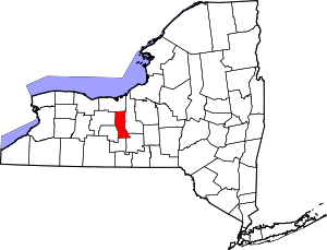 | |
| Towns | ||
| Villages | ||
| CDP | ||
| Hamlets |
| |
| Footnotes | ‡This populated place also has portions in an adjacent county or counties | |