Roman road from Silchester to Bath
The route from Londinium (London) to Aquae Sulis (Bath) comprised the road from Aquae Sulis to Calleva (Silchester) and then the Devil's Highway connecting Calleva to Londinium.
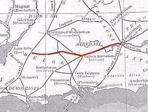
The Roman road from Silchester to Bath connected Calleva Atrebatum (Silchester) with Aquae Sulis (Bath) via Spinae (Speen) and Cunetio.[1] Portions of the original road are extant, and in certain other places all apparent vestiges are absent from view. The road was a significant route for east-west travel and military logistics in southeast England during the 1st to 5th centuries. During the Middle Ages, the road was used by drovers, as well as by merchants and travelers.
See also
- Akeman Street
- Devil's Highway, the continuation of this road from Silchester to London
- Roman roads in Britain
References
Coordinates: 51°21′31″N 1°01′54″W / 51.35857°N 1.03177°W
This article is issued from Wikipedia - version of the 1/21/2016. The text is available under the Creative Commons Attribution/Share Alike but additional terms may apply for the media files.