Roeland Park, Kansas
| Roeland Park, Kansas | |
|---|---|
| City | |
 Location within Johnson County and Kansas | |
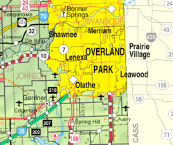 KDOT map of Johnson County (legend) | |
| Coordinates: 39°2′5″N 94°38′21″W / 39.03472°N 94.63917°WCoordinates: 39°2′5″N 94°38′21″W / 39.03472°N 94.63917°W | |
| Country | United States |
| State | Kansas |
| County | Johnson |
| Incorporated | 1951 |
| Government | |
| • Mayor | Joel Marquardt |
| Area[1] | |
| • Total | 1.62 sq mi (4.20 km2) |
| • Land | 1.62 sq mi (4.20 km2) |
| • Water | 0 sq mi (0 km2) |
| Elevation | 988 ft (301 m) |
| Population (2010)[2] | |
| • Total | 6,731 |
| • Estimate (2012[3]) | 6,816 |
| • Density | 4,200/sq mi (1,600/km2) |
| Time zone | CST (UTC-6) |
| • Summer (DST) | CDT (UTC-5) |
| ZIP codes | 66205 and 66202 |
| Area code | 913 |
| FIPS code | 20-60825 [4] |
| GNIS ID | 0479030 [5] |
| Website | roelandpark.net |
Roeland Park is a city in Johnson County, Kansas, United States, and part of the Kansas City metropolitan area. As of the 2010 census, the city population was 6,731.[6]
History
The City of Roeland Park was originally named after John Roe, an immigrant from Ireland who settled on 267 acres (1.08 km2) in 1883, on part of which Roeland Park now stands. The Roe Home was built in 1891 and razed in 1958 to make room for the interchange at Roe Boulevard and Shawnee Mission Parkway.[7]
Roeland Park's original pool was built in 1958 on land donated by the Roe Estate. The new pool facility is located on the east side of the Community Center at 4843 Rosewood Drive. The Community Center address is 4850 Rosewood Drive and offers many different programs throughout the year. A fabric dome which covers the main pool is in place from September through May, allowing residents to use the main pool throughout the year.[8]
Geography
Roeland Park is located at 39°02′05″N 94°38′21″W / 39.034705°N 94.639211°W (39.034705, -94.639211).[9] According to the United States Census Bureau, the city has a total area of 1.62 square miles (4.20 km2), all of it land.[1]
Demographics
| Historical population | |||
|---|---|---|---|
| Census | Pop. | %± | |
| 1960 | 8,949 | — | |
| 1970 | 9,760 | 9.1% | |
| 1980 | 7,962 | −18.4% | |
| 1990 | 7,706 | −3.2% | |
| 2000 | 6,817 | −11.5% | |
| 2010 | 6,731 | −1.3% | |
| Est. 2015 | 6,827 | [10] | 1.4% |
| U.S. Decennial Census | |||
2010 census
As of the census[2] of 2010, there were 6,731 people, 3,065 households, and 1,732 families residing in the city. The population density was 4,154.9 inhabitants per square mile (1,604.2/km2). There were 3,282 housing units at an average density of 2,025.9 per square mile (782.2/km2). The racial makeup of the city was 87.6% White, 3.7% African American, 0.4% Native American, 1.5% Asian, 3.8% from other races, and 3.0% from two or more races. Hispanic or Latino of any race were 10.4% of the population.
There were 3,065 households of which 26.6% had children under the age of 18 living with them, 42.2% were married couples living together, 10.4% had a female householder with no husband present, 3.9% had a male householder with no wife present, and 43.5% were non-families. 33.0% of all households were made up of individuals and 7.7% had someone living alone who was 65 years of age or older. The average household size was 2.20 and the average family size was 2.82.
The median age in the city was 34.1 years. 20% of residents were under the age of 18; 8.4% were between the ages of 18 and 24; 36% were from 25 to 44; 24.5% were from 45 to 64; and 11.1% were 65 years of age or older. The gender makeup of the city was 48.4% male and 51.6% female.
2000 census
As of the census[4] of 2000, there were 6,817 people, 3,007 households, and 1,798 families residing in the city. The population density was 4,197.8 people per square mile (1,624.7/km2). There were 3,115 housing units at an average density of 1,918.1 per square mile (742.4/km2). The racial makeup of the city was 92.39% White, 1.97% African American, 0.45% Native American, 1.42% Asian, 0.10% Pacific Islander, 2.16% from other races, and 1.51% from two or more races. Hispanic or Latino of any race were 6.65% of the population.
There were 3,007 households out of which 26.9% had children under the age of 18 living with them, 46.9% were married couples living together, 10.2% had a female householder with no husband present, and 40.2% were non-families. 32.5% of all households were made up of individuals and 10.5% had someone living alone who was 65 years of age or older. The average household size was 2.27 and the average family size was 2.91.
In the city the population was spread out with 21.8% under the age of 18, 7.8% from 18 to 24, 35.5% from 25 to 44, 21.1% from 45 to 64, and 13.8% who were 65 years of age or older. The median age was 36 years. For every 100 females there were 91.5 males. For every 100 females age 18 and over, there were 86.7 males.
The median income for a household in the city was $51,455, and the median income for a family was $61,750. Males had a median income of $40,504 versus $32,212 for females. The per capita income for the city was $26,220. About 3.0% of families and 5.2% of the population were below the poverty line, including 6.5% of those under age 18 and 4.4% of those age 65 or over.
Education
The city is a part of the Shawnee Mission School District.
Roesland Elementary School, St. Agnes Elementary School and Bishop Miege High School are located in the city.[11]
Libraries
The Johnson County Library serves residents of Roeland Park. The library's Cedar Roe branch is in Roeland Park.
Notable people
Notable individuals who were born in and/or have lived in Roeland Park include:
- John D. Carmack (1970- ), computer programmer[12]
- Catherine Fox (1977- ), swimmer, winner of two Gold Medals at the 1996 Olympics in Atlanta, Georgia[13]
- Mike Gardner (1967- ), football coach[14]
- Nia Williams (1990- ), soccer defender[15]
References
- 1 2 "US Gazetteer files 2010". United States Census Bureau. Retrieved 2012-07-06.
- 1 2 "American FactFinder". United States Census Bureau. Retrieved 2012-07-06.
- ↑ "Population Estimates". United States Census Bureau. Retrieved 2013-05-29.
- 1 2 "American FactFinder". United States Census Bureau. Retrieved 2008-01-31.
- ↑ "US Board on Geographic Names". United States Geological Survey. 2007-10-25. Retrieved 2008-01-31.
- ↑ "2010 City Population and Housing Occupancy Status". U.S. Census Bureau. Retrieved August 15, 2012.
- ↑ "John Roe House :: Album, the Newsletter of the Johnson County Museum". JoCoHistory. Retrieved August 18, 2012.
- ↑ "Aquatic Center". City of Roeland Park. Retrieved August 18, 2012.
- ↑ "US Gazetteer files: 2010, 2000, and 1990". United States Census Bureau. 2011-02-12. Retrieved 2011-04-23.
- ↑ "Annual Estimates of the Resident Population for Incorporated Places: April 1, 2010 to July 1, 2015". Retrieved July 2, 2016.
- ↑ "SECTION 2 EXISTING CONDITIONS" (PDF). July 17, 2012. Retrieved August 18, 2012.
- ↑ "John Carmack". IMDb. Retrieved 2016-03-25.
- ↑ "Catherine Fox". Sports-Reference.com. Retrieved 2016-03-25.
- ↑ "Mike Gardner returns to the helm of Bluejay football at Tabor College". Kansas Collegiate Athletic Conference. 2009-12-02. Retrieved 2016-03-25.
- ↑ "Nia Williams". FC Kansas City. Retrieved 2016-03-25.
External links
| Wikimedia Commons has media related to Roeland Park, Kansas. |
- City
- Maps
- Roeland Park City Map, KDOT
Municipalities and communities of Johnson County, Kansas, United States | ||
|---|---|---|
| Cities | 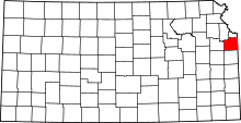 | |
| Unincorporated communities | ||
| Townships | ||
| Footnotes | ‡This populated place also has portions in an adjacent county or counties | |
Kansas City metropolitan area's cities and counties | ||
|---|---|---|
| Central city | 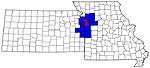 | |
| Largest cities (over 100,000 in 2000) | ||
| Medium-sized cities (10,000 to 100,000 in 2000) | ||
| Smaller Cities (between 5,000 and 9,900 in 2010) | ||
| Counties | ||