Rocky Ford, Colorado
| Rocky Ford, Colorado | |
|---|---|
| City | |
|
Rocky Ford City Hall | |
 Location in Otero County and the state of Colorado | |
| Coordinates: 38°3′4″N 103°43′17″W / 38.05111°N 103.72139°WCoordinates: 38°3′4″N 103°43′17″W / 38.05111°N 103.72139°W | |
| Country |
|
| State |
|
| County[1] | Otero County[2] |
| Incorporated | August 19, 1887[3] |
| Government | |
| • Type | Statutory City[1] |
| Area | |
| • Total | 1.7 sq mi (4.4 km2) |
| • Land | 1.7 sq mi (4.4 km2) |
| • Water | 0 sq mi (0 km2) |
| Elevation[2] | 4,180 ft (1,274 m) |
| Population (2000) | |
| • Total | 4,286 |
| • Density | 2,521.2/sq mi (974.1/km2) |
| Time zone | Mountain (MST) (UTC-7) |
| • Summer (DST) | MDT (UTC-6) |
| ZIP code[4] | 81067 |
| Area code(s) | 719 |
| FIPS code | 08-65190 |
| GNIS feature ID | 0195481 |
| Website | rockyfordcolo.com |

Rocky Ford is a Statutory City located in Otero County, Colorado, United States. The population was 4,286 at the United States Census 2000.
The community was named for a rocky ford near the original town site.[5]
Geography
Rocky Ford is located at 38°3′4″N 103°43′17″W / 38.05111°N 103.72139°W (38.051000, -103.721387).[6]
According to the United States Census Bureau, the city has a total area of 1.7 square miles (4.4 km2), of which, 1.7 square miles (4.4 km2) of it is land and 0.58% is water.
Demographics
| Historical population | |||
|---|---|---|---|
| Census | Pop. | %± | |
| 1880 | 47 | — | |
| 1890 | 468 | 895.7% | |
| 1900 | 2,018 | 331.2% | |
| 1910 | 3,230 | 60.1% | |
| 1920 | 3,746 | 16.0% | |
| 1930 | 3,426 | −8.5% | |
| 1940 | 3,493 | 2.0% | |
| 1950 | 4,087 | 17.0% | |
| 1960 | 4,929 | 20.6% | |
| 1970 | 4,859 | −1.4% | |
| 1980 | 4,804 | −1.1% | |
| 1990 | 4,162 | −13.4% | |
| 2000 | 4,286 | 3.0% | |
| 2010 | 3,957 | −7.7% | |
| Est. 2015 | 3,827 | [7] | −3.3% |
As of the census[9] of 2000, there were 4,286 people, 1,655 households, and 1,136 families residing in the city. The population density was 2,521.8 people per square mile (973.4/km²). There were 1,852 housing units at an average density of 1,089.7 per square mile (420.6/km²). The racial makeup of the city was 72.42% White, 0.40% African American, 1.47% Native American, 0.75% Asian, 0.12% Pacific Islander, 21.86% from other races, and 2.99% from two or more races. Hispanic or Latino of any race were 57.14% of the population.
There were 1,655 households out of which 33.0% had children under the age of 18 living with them, 48.1% were married couples living together, 15.5% had a female householder with no husband present, and 31.3% were non-families. 28.0% of all households were made up of individuals and 12.7% had someone living alone who was 65 years of age or older. The average household size was 2.53 and the average family size was 3.07.
In the city the population was spread out with 28.2% under the age of 18, 8.7% from 18 to 24, 23.9% from 25 to 44, 21.6% from 45 to 64, and 17.6% who were 65 years of age or older. The median age was 37 years. For every 100 females there were 95.9 males. For every 100 females age 18 and over, there were 91.2 males.
The median income for a household in the city was $23,359, and the median income for a family was $29,470. Males had a median income of $26,271 versus $17,485 for females. The per capita income for the city was $12,742. About 14.6% of families and 20.3% of the population were below the poverty line, including 28.2% of those under age 18 and 11.6% of those age 65 or over.
Economy
Rocky Ford is noted for its cantaloupes and watermelons.[10]
Transportation
Bus service is provided daily eastward towards Wichita, Kansas and westward towards Pueblo, Colorado by BeeLine Express (subcontractor of Greyhound Lines).[11][12]
Notable people
Notable individuals who were born in and/or have lived in Rocky Ford include:
- Marvin Cordova, Jr. (1985- ), light welterweight boxer[13]
- Paul Gebhard (1917-2015), anthropologist, sexologist[14]
- Blaine Gibson (1918–2015), Disney sculptor (The Hall of Presidents, Haunted Mansion, Pirates of the Caribbean) and animator[15][16]
- Earl T. Newbry (1900-1995), Oregon Secretary of State[17]
- Manuel T. Pacheco (1941- ), university president[18]
- George W. Swink (1836-1910), land developer, fruit grower[19]
- Robert Swink (1918-2000), film editor[20]
- John D. Vanderhoof (1922-2013), 37th Governor of Colorado[21]
Gallery
 Rocky Ford welcome sign
 Restored railroad depot in Rocky Ford
 Downtown Rocky Ford on U.S. Highway 50
 Grand Theatre in Rocky Ford
 First National Bank of Rocky Ford
 First Baptist Church in Rocky Ford
 Community Presbyterian Church in Rocky Ford; pastor Steve L. Culver (2010)
 First Christian Church in Rocky Ford
 Christine's Restaurant operates in a former church in Rocky Ford.
See also
- Outline of Colorado
- State of Colorado
- Arkansas River
- Rocky Ford High School
- Rocky Ford Station
- George W. Swink, town pioneer
References
- 1 2 "Active Colorado Municipalities". State of Colorado, Department of Local Affairs. Retrieved 2007-09-01.
- 1 2 "US Board on Geographic Names". United States Geological Survey. 2007-10-25. Retrieved 2008-01-31.
- ↑ "Colorado Municipal Incorporations". State of Colorado, Department of Personnel & Administration, Colorado State Archives. 2004-12-01. Retrieved 2007-09-02.
- ↑ "ZIP Code Lookup" (JavaScript/HTML). United States Postal Service. Retrieved December 26, 2007.
- ↑ Dawson, John Frank. Place names in Colorado: why 700 communities were so named, 150 of Spanish or Indian origin. Denver, CO: The J. Frank Dawson Publishing Co. p. 43.
- ↑ "US Gazetteer files: 2010, 2000, and 1990". United States Census Bureau. 2011-02-12. Retrieved 2011-04-23.
- ↑ "Annual Estimates of the Resident Population for Incorporated Places: April 1, 2010 to July 1, 2015". Retrieved July 2, 2016.
- ↑ "Census of Population and Housing". Census.gov. Retrieved June 4, 2015.
- ↑ "American FactFinder". United States Census Bureau. Retrieved 2008-01-31.
- ↑ "Colorado more than mountains". Boca Raton News. Nov 6, 1983. p. 2. Retrieved 7 May 2015.
- ↑ BeeLine Express
- ↑ Greyhound Lines
- ↑ "Marvin Cordova Jr". BoxRec. Retrieved 2016-06-24.
- ↑ Roberts, Sam (2015-07-22). "Paul Gebhard, Sex Researcher Who Worked With Kinsey, Dies at 98". The New York Times. Retrieved 2016-06-24.
- ↑ Colker, David (2015-07-08). "Blaine Gibson dies at 97; prominent sculptor, animator at Disney". Los Angeles Times. Retrieved 2015-08-04.
- ↑ Weber, Bruce (2015-07-11). "Blaine Gibson, Sculptor of Figures in Disney Parks, Dies at 97". New York Times. Retrieved 2015-08-04.
- ↑ "Oregon Secretaries of State Biographical Sketches, 1841-Present". Oregon Blue Book. Retrieved 2016-06-24.
- ↑ "Manuel Trinidad Pacheco". University of Arizona. Retrieved 2016-06-24.
- ↑ "Our History". Rocky Ford Growers Association. Retrieved 2016-06-24.
- ↑ "Robert Swink". IMDb. Retrieved 2016-06-24.
- ↑ AP (2013-09-23). "Former Colorado Gov. Vanderhoof dies at 91". The Denver Post. Retrieved 2016-06-24.
External links
Municipalities and communities of Otero County, Colorado, United States | ||
|---|---|---|
| Cities | 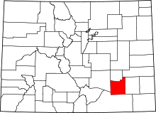 | |
| Towns | ||
| CDPs | ||
| Unincorporated communities | ||
| Ghost town | ||
