Rockledge, Florida
| Rockledge, Florida | |
|---|---|
| City | |
| City of Rockledge | |
| Motto: "Preserving The Past, Planning The Future"[1] | |
 Location in Brevard County and the state of Florida | |
| Coordinates: 28°19′30″N 80°43′58″W / 28.32500°N 80.73278°WCoordinates: 28°19′30″N 80°43′58″W / 28.32500°N 80.73278°W | |
| Country |
|
| State |
|
| County |
|
| Founded | August 7, 1887 |
| Founded by | Gardner S. Hardee |
| Government | |
| • Type | Council-Manager |
| • Mayor | Thomas J. Price |
| • City Manager | James P. “Jim” McKnight |
| • Deputy Mayor, Chairman | Frank T. Forrester |
| • Vice Chairman | Richard K. "Dick" Blake |
| Area | |
| • Total | 13.4 sq mi (34.8 km2) |
| • Land | 11.9 sq mi (30.9 km2) |
| • Water | 1.5 sq mi (3.8 km2) |
| Elevation | 23 ft (7 m) |
| Population (2010)[2] | |
| • Total | 24,926 |
| • Density | 1,900/sq mi (720/km2) |
| Time zone | Eastern (EST) (UTC-5) |
| • Summer (DST) | EDT (UTC-4) |
| ZIP codes | 32955-32956 |
| Area code(s) | 321 |
| FIPS code | 12-61500[3] |
| GNIS feature ID | 0294132[4] |
| Website |
www |
Rockledge /ˈrɒklɪdʒˌ-ˌlɛdʒ/ is the oldest city in Brevard County, Florida. The city's population was 24,926 at the 2010 United States Census,[2] and is part of the Palm Bay−Melbourne−Titusville Metropolitan Statistical Area.
History
.jpg)
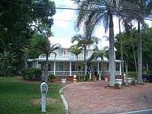
Rockledge was officially founded on August 7, 1887, making it the oldest incorporated municipality in Brevard County.[5] The name Rockledge, attributed to Gardner S. Hardee, an early settler, comes from the many ledges of coquina rock that line the Indian River.[6] Other sources refer to a man named Cephas Bailey Magruder, who built his home after settling in the area in 1876 near the Indian River. Magruder called his home "the rockledge home" and the name was eventually attributed to the whole town.[7][8] It was originally referred to as Rock Ledge; the two-word name persisted through the 19th century.[9] Early industry in the area was based on the citrus trade and accommodation for tourists traveling to South Florida via the Atlantic Intracoastal Waterway of the Indian River.
Towards the early part of the 20th century, Rockledge was known as a resort town. In the winter months, the population would rise from 200 to almost 2,000 people. Up until about 1911, access to Rockledge was via boat and rail. Steamboats in the Indian River connected with Henry Flagler's trains to bring people to the North. Small boats, sailboats, and small launches frequently stopped to unload freight and passengers. Most of the tourists in this time were wealthy and would use the boats to connect to the rail system at that time. After World War I, the automobile allowed the average person to travel to the area and their encampments dotted the area. The Dixie Highway was completed in 1915 and spanned most of Florida. In the 1920s, US1 was paved and replaced the Dixie Highway.[10]
President Grover Cleveland and his wife visited the city in 1888.[11]
The town had several large hotels in the late 19th century to the early 20th century that catered to Northern tourists escaping cold winters. Condominiums are located at the previous site of Hotel Indian River.
Rockledge underwent an expansion further west and south in the 1960s when it became a bedroom community for the nearby Kennedy Space Center. Several hundred families from all over the United States settled in the city with the advent of the Apollo missions and the space shuttle program.
Barton Boulevard replaced US 1 as the town's economic center as new subdivisions spread south along Fiske Boulevard. By the 1970s, the bulk of Rockledge's population lived between US 1 and I-95.
Developments stretched north to south from the late 1950s to the 1990s. Virginia Park, Marlin Manor, Fairway Estates, Rockledge Country Club Estates, Golfview Estates, Kings Grant, Georgetown, Levitt Park and Woodsmere had all been established by the 1970s.
Levitt Park and Woodsmere were built atop a gladiola farm and an orange grove. The huge Australian Pine trees at the southernmost points of Fiske Boulevard are all that remain of the grove's windbreaks. The subdivision of Silver Pines, while part of unincorporated Brevard County outside the city limit, was also built during this period and is identified by citizens as a part of the city.
Geography
According to the United States Census Bureau, the city has a total area of 13.4 square miles (34.8 km2), of which 11.9 square miles (30.9 km2) is land and 1.5 square miles (3.8 km2) (11.03%) is water.[12]
It is bounded on the north by Cocoa, on the west by the St. Johns River and scrubland, to the south by Viera (unincorporated) and Melbourne, and to the east by the Indian River Lagoon and Merritt Island (unincorporated) on the opposite shore.
 |
Cocoa | | ||
| St. Johns River | |
Indian River | ||
| ||||
| | ||||
| Viera |
Climate
Rockledge has a humid subtropical climate, Köppen climate classification Cfa. The area's warm and humid climate is caused primarily by its proximity to the Gulf Stream, which flows off the east coast of Florida. There are two major seasons which characterize the area. One is hot and rainy, lasting from June until late September. The other is the dry season, October through May, brings more moderate temperatures and less frequent rainfall.[13]
| Climate data for Rockledge, Florida | |||||||||||||
|---|---|---|---|---|---|---|---|---|---|---|---|---|---|
| Month | Jan | Feb | Mar | Apr | May | Jun | Jul | Aug | Sep | Oct | Nov | Dec | Year |
| Record high °F (°C) | 89 (32) |
92 (33) |
93 (34) |
97 (36) |
97 (36) |
101 (38) |
102 (39) |
101 (38) |
98 (37) |
96 (36) |
91 (33) |
89 (32) |
102 (39) |
| Average high °F (°C) | 71 (22) |
74 (23) |
77 (25) |
81 (27) |
86 (30) |
90 (32) |
91 (33) |
91 (33) |
88 (31) |
84 (29) |
79 (26) |
73 (23) |
82.1 (27.8) |
| Average low °F (°C) | 49 (9) |
52 (11) |
55 (13) |
60 (16) |
67 (19) |
72 (22) |
73 (23) |
73 (23) |
73 (23) |
68 (20) |
60 (16) |
53 (12) |
62.9 (17.3) |
| Record low °F (°C) | 17 (−8) |
27 (−3) |
25 (−4) |
35 (2) |
47 (8) |
55 (13) |
60 (16) |
60 (16) |
58 (14) |
41 (5) |
30 (−1) |
21 (−6) |
17 (−8) |
| Average precipitation inches (mm) | 2.27 (57.7) |
2.63 (66.8) |
3.28 (83.3) |
2.13 (54.1) |
3.29 (83.6) |
6.71 (170.4) |
5.96 (151.4) |
7.68 (195.1) |
7.64 (194.1) |
5.06 (128.5) |
2.88 (73.2) |
2.57 (65.3) |
52.1 (1,323.5) |
| Source: Weather Channel accessdate February 29, 2012 | |||||||||||||
Environment
Rainfall can run off from the city into the Indian River Lagoon, with resultant pollution. As a result, the city has banned fertilizing from June 1 to September 30 annually.[14]
Demographics
| Historical population | |||
|---|---|---|---|
| Census | Pop. | %± | |
| 1920 | 453 | — | |
| 1930 | 551 | 21.6% | |
| 1940 | 725 | 31.6% | |
| 1950 | 1,347 | 85.8% | |
| 1960 | 3,481 | 158.4% | |
| 1970 | 10,523 | 202.3% | |
| 1980 | 11,877 | 12.9% | |
| 1990 | 16,023 | 34.9% | |
| 2000 | 20,170 | 25.9% | |
| 2010 | 24,926 | 23.6% | |
| Est. 2015 | 26,626 | [15] | 6.8% |
As of the census[3] of 2000, there were 20,170 people, 7,864 households, and 5,677 families residing in the city. The population density was 1,884.4 inhabitants per square mile (727.8/km²). There were 8,353 housing units at an average density of 780.4 per square mile (301.4/km²). The racial makeup of the city was 81.06% White, 14.64% African American, 0.28% Native American, 1.66% Asian, 0.08% Pacific Islander, 0.73% from other races, and 1.56% from two or more races. Hispanic or Latino of any race were 3.28% of the population.
There were 7,864 households out of which 31.0% had children living with them, 56.8% were married couples living together, 11.9% had a female householder with no husband present, and 27.8% were non-families. 22.5% of all households were made up of individuals and 9.5% had someone living alone who was 65 years of age or older. The average household size was 2.51 and the average family size was 2.93.
Per the 2000 Census, the population was distributed as follows:
- 23.8% under the age of 18
- 6.0% from 18 to 24
- 28.6% from 25 to 44
- 25.2% from 45 to 64
- 16.4% who were 65 years of age or older.
The median age was 40 years. For every 100 females there were 90.6 males. For every 100 females age 18 and over, there were 87.3 males.
In 2010, the city had the lowest percentage of people living in poverty of any municipality measured in the county, 5%, compared to an average of 10% countywide.[17]
Museums and other points of interest
- H. S. Williams House
- Rockledge Drive Residential District[18]
- Marion S. Whaley Citrus Packing House[18]
- Persimmon Mound[18]
- Barton Avenue Residential District[18]
- Valencia Subdivision Residential District[18]
Parks and recreation
Rockledge has the following parks:[19]
- Anderson Stormwater Park
- Barton Park [under construction]
- Columbia Park
- Dick Blake Park
- Cruickshank Sanctuary
- Golfview Park
- Holland Park
- McClarty Park
- Memorial Walk at Levitt Park
- Morris Park
- Raider Park
- River Groves Dock
- Riverwalk - A Family Park
- Rockledge Park
- Silver Pines Park
- Taylor Park
- Valencia Dock
Government
The City of Rockledge functions under a Council-Manager government. The Mayor and City Council members are elected to three-year terms. There are six City Council members whose terms are staggered to allow election of two council seats each year. The city holds municipal elections on the first Tuesday after the first Monday of November each year.
While the Mayor and the City Council act as the legislative body of the City of Rockledge, the actual operation of the city and its functions lies with the City Manager and his departmental support staff consisting of Assistant City Manager/Finance Director, City Clerk/Public Relations Officer, Building Official, Fire Chief, Chief of Police, Director of Public Works and Director of Wastewater Treatment and Water Reclamation.
The Chairman of the City Council appoints members of the City Council to serve on subcommittees and to represent the City Council on other governmental bodies that require the city's input.[20]
In 2013, there were 237 city employees.[21]
Finances
In 2007, the city had a taxable real estate base of $1.55 billion.[22]
In 2009-10, the city paid $2.2 million for solid waste disposal. This was furnished at a cost of $168.48 annually per residence. Non residential (business) collection cost $632.89 each, annually.[23]
Police
Rockledge has approximately fifty full-time certified police officers serving the city.[24] In addition, there are 18 support staff positions, five reserve officers, eight crossing guards, and seven civilian volunteers.[24] All police officers must be certified by the State of Florida.[24] In August 2011, the new $4 million police headquarters was finished and it is located at 1776 Jack Oates Blvd.[25] The old police station on Barton Blvd may be home to a future library and other non-profit organizations, who will lease the former police headquarters from the city.[26][27]
Fire protection
Along with one other city in the county, Rockledge has its own fire department with three stations. There is a county fire department within the city limits.[28]
Boards and committees
The City of Rockledge contains several citizen-run boards and committees that make recommendations to the city on various issues. The positions held on the boards and committees are on a voluntary basis and non-paid. The boards and committees of Rockledge are:[29]
- Board of Adjustment
- Board of Adjustment and Appeals
- Business Development Committee
- Citizens Advisory Committee
- Citizens Recreation Advisory Board
- Code Enforcement Board
- Community Redevelopment Agency Board of Commissioners
- Education Advisory Committee
- Planning Commission
- Retirement Board, Fire Employees
- Retirement Board, General Employees
- Retirement Board, Police Employees
- The Rockledge Environmental Enhancement Board[30]
The city publishes an official newsletter for residents of Rockledge.
Mayors
- Fiske 1929-1933
- Geiger 1940-1952
- Barnes 1959-1962
- Grady 1965-1974
- Jack Oates 1975-1998
- Larry L. Schultz 1999-2010
- Thomas J. Price 2011-current [31]
Economy
Local businesses focus on technology and aerospace, especially those related to nearby Kennedy Space Center and Cape Canaveral.
Citrus grove production is nominal, producing citrus confections, juice and souvenirs for the tourist trade and for local consumption.
Personal income
The median income for a household in the city was $45,218, and the median income for a family was $52,332. Males had a median income of $39,434 versus $25,918 for females. The per capita income for the city was $20,700. About 4.0% of families and 6.5% of the population were below the poverty line, including 6.2% of those under age 18 and 7.2% of those age 65 or over.
Industry
The leading industries in Rockledge are Educational, health and social services, 20%; Manufacturing, 12%; and Professional, scientific, management, administrative, and waste management services, 11%.[32]
Rivian Automotive, a tiny start-up, plans to begin production of cars in 2013.[33]
Tourism
Rockledge has the following annual community events, festivals, and parades:[34]
- Art/Craft Fair
- Cruise-On-In Car Show
- Independence Day Family Picnic
- Light Up Rockledge and Holiday Parade
- Memorial Day Parade
- National Night Out
- Taylor Park Fall Family Festival
Workforce
In 2007, the average size of Rockledge's labor force was 11,886. Of that group, 11,455 were employed and 431 were unemployed, for an unemployment rate of 3.6%.[35]
Among the most common occupations in Rockledge are Management, professional, and related occupations, 36%. Sales and office occupations, 28%. and Service occupations, 15%. Approximately 72 percent of workers in Rockledge, Florida work for companies, 19 percent work for the government and 6 percent are self-employed.[32]
Housing
Reflecting economic times, in 2008, 45 building permits were issued for 105 units. In 2007, 131 permits were issued for 158 units. Also, in 2006, an estimated 106 permits for 341 units were issued.[36]
The median home price in 2007 was $214,965.[35]
In February 2011, the average price of homes actually sold was $131,500.[37]
Education
The public schools in Rockledge are operated by the Brevard County Public School Board. Local schools include Hans Christian Andersen Elementary; Golfview Elementary; John F. Kennedy Middle School; Ronald McNair Magnet Middle School;[38] and Rockledge High School.
Private schools include St. Mary's Catholic School,[39] Rockledge Christian School,[40] Trinity Lutheran School,[41] and Rockledge Montessori School.[42]
Infrastructure
Transportation
Major roads
Rockledge is served by U.S. Route 1. Major east west roads are oriented towards this north-south road.
The following are at least four-lane roads, unless otherwise designated.
- National roads
-
 U.S. 1. It was constructed east of the railroad throughout the city. In 2010, this road was widened to six lanes throughout Rockledge. A landscaped median was installed. Construction in 2010 cost $27.5 million for 2.6 miles (4.2 km). This section of the road carries approximately 45,000 vehicles daily.[43]
- State roads
-
 SR 519 (Fiske Blvd) is a state road which at the southernmost point connects to Stadium Parkway in Viera and at the northernmost point to SR 520 in Cocoa. SR 519 is a four-lane road.[44]
- County roads
-
 CR 502 (Barnes Blvd) links US 1, Murrell Road, SR 519 and I-95. CR 502 is a two-lane road except for the easternmost portion which has four lanes that eventually merge into two.[44]
 -
 CR 515 (Rockledge Drive) winds along the Indian River edge and is a portion of the Indian River Lagoon Scenic Highway. Along the road are century-old oaks and homes in late 18th century style.[7]
Bus
- Space Coast Area Transit operates a public bus service in Rockledge and vicinity.[45]
Rail
- The Florida East Coast Railway runs through Rockledge but does not stop. Historically, there was a stop on the Florida East Coast Railway, but it was abandoned when passenger service become unprofitable for the Florida East Coast Railway.[46]
Air
- The city has a private runway at the Rockledge Airpark run by Aero Adventures, Inc and is used by private individuals for leisure. The paved runway is approximately 2000 feet with a parallel grass runway on the east side of the property.[47]
Notable people
- Lyman Barnes, Wisconsin politician, practiced law in Rockledge for five years.[48]
- Lucas "Tiger" Fafara, II, child actor best remembered for his role as Tooey Brown in the television sitcom Leave it to Beaver (1957-1963).
- Tammy Lynn Leppert, former actress
- Troy Matteson, PGA Tour golfer[49]
- DeLane Matthews, actress, most notably as Beth Barry on Dave's World (1993–1997)
- Mel Mitchell, American professional football player
- Jessi Peralta, Contestant on So You Think You Can Dance 2007[50]
- Laurent Robinson, professional American football player
- Scott Thompson, Comedian, also known as Carrot Top, was born in Rockledge.
- Melissa Witek, Miss Florida USA 2005 and contestant on NBC's Treasure Hunters
References
- ↑ "City of Rockledge Florida Website". City of Rockledge Florida Website. Retrieved September 21, 2012.
- 1 2 "Profile of General Population and Housing Characteristics: 2010 Demographic Profile Data (DP-1): Rockledge city, Florida". U.S. Census Bureau, American Factfinder. Retrieved January 30, 2012.
- 1 2 "American FactFinder". United States Census Bureau. Retrieved 2008-01-31.
- ↑ "US Board on Geographic Names". United States Geological Survey. 2007-10-25. Retrieved 2008-01-31.
- ↑ About Rockledge
- ↑ "Profile for Rockledge, Florida, FL". ePodunk. Retrieved September 21, 2012.
- 1 2 http://www.scenicusa.net/092509.html
- ↑ http://www.reocities.com/yosemite/rapids/8428/hikeplans/cocoa-rockledge/plancocoarock.html
- ↑ More History of Rockledge
- ↑ http://ww3.brevardcounty.us/history/documents/02fall.pdf
- ↑ Indian River Lagoon History
- ↑ "Geographic Identifiers: 2010 Demographic Profile Data (G001): Rockledge city, Florida". U.S. Census Bureau, American Factfinder. Retrieved January 30, 2012.
- ↑ http://www.weather.com/outlook/travel/businesstraveler/wxclimatology/monthly/32955
- ↑ Waymer, Jim (March 29, 2013). "Fertilizer". Florida Today. Melbourne, Florida. pp. 2B.
- ↑ "Annual Estimates of the Resident Population for Incorporated Places: April 1, 2010 to July 1, 2015". Retrieved July 2, 2016.
- ↑ "Census of Population and Housing". Census.gov. Retrieved June 4, 2015.
- ↑ Ryan, MacKenzie (15 December 2010). "Census data notes makeup of towns". Melbourne, Florida: Florida Today. pp. 1A.
- 1 2 3 4 5 Rockledge Historic Places
- ↑ City of Rockledge Parks
- ↑ Mayor & City Council City of Rockledge. Retrieved on 2009-06-23
- ↑ Gunnerson, Scott (April 8, 2013). "ity offers deal to retire". Florida Today. Melbourne, Florida. pp. 1B.
- ↑ Dean, James (April 26, 2008). More taxes or fewer services. Florida Today.
- ↑ "City of Rockledge:Full Cost Accounting of Solid Waste Services Fiscal year - 2009 - 2010 (paid public notice)". Florida Today. Melbourne, Florida. March 31, 2011. pp. 2B.
- 1 2 3 http://www.cityofrockledge.org/pages/rockledgefl_police/index
- ↑ http://articles.orlandosentinel.com/2011-08-13/news/os-rockledge-cops-new-station-20110813_1_new-headquarters-rockledge-barton-boulevard
- ↑ Berman, Dave (27 December 2011). "Rockledge leases part of former police headquarters". Florida Today.
- ↑ Cervenka, Susanne (2 June 2011). "Rockledge police station to become community resource center". Florida Today.
- ↑ "The Fact Book". Florida Today. Melbourne, Florida. March 26, 2011. p. 29.
- ↑ List of City of Rockledge Boards and Committees
- ↑ About Town
- ↑ http://fl-rockledge.civicplus.com/129/City-Council
- 1 2 Simply Hired : Rockledge, FL
- ↑ "Avera Motors of Rockledge becomes Rivian Automotiv". Florida Today. 10 March 2011. Archived from the original on 17 March 2011. Retrieved 17 March 2011.
- ↑ http://www.cityofrockledge.org/Pages/RockledgeFL_WebDocs/events1
- 1 2 Rockledge Community Data Sheet Economic Development Council of Florida's Space Coast. Retrieved on 2009-06-23
- ↑ Building Permits United States Census Bureau. Retrieved on 2009-06-23
- ↑
- ↑ Ronald McNair Magnet Middle School
- ↑ St. Mary's Catholic School
- ↑ Rockledge Christian School
- ↑ Trinity Lutheran School
- ↑ Rockledge Montessori School
- ↑ Basu, Rebecca (3 December 2010). "Rockledge U.S. 1 upgrade is done". Melbourne, Florida: Florida Today. pp. 1B.
- 1 2 http://www.cityofrockledge.org/Pages/RockledgeFL_Council/Election%20History.pdf
- ↑ Space Coast Area Transit official website
- ↑ Florida East Coast Railway#Main line
- ↑ http://www.sea-plane.com/Aero%20Adventure/About%20Us.html
- ↑ 'Wisconsin Blue Book 1893,' Biographical Sketch of Lyman E. Barnes, pg. 621
- ↑ "Profile on PGA Tour's official site". Retrieved March 5, 2011.
- ↑ http://www.tvguide.com/news/you-think-dance-41803.aspx
External links
| Wikimedia Commons has media related to Rockledge, Florida. |
- www
.cityofrockledge .org - City-Data.com Comprehensive Statistical Data and more about Rockledge
- Local Newspaper- Town Rockledge
Municipalities and communities of Brevard County, Florida, United States | ||
|---|---|---|
| Cities | 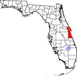 | |
| Towns | ||
| CDPs | ||
| Unincorporated communities | ||