Rochester, Washington
| Rochester, Washington | |
|---|---|
| CDP | |
|
Rochester Community Center | |
 Location of Rochester, Washington | |
| Coordinates: 46°49′25″N 123°5′0″W / 46.82361°N 123.08333°WCoordinates: 46°49′25″N 123°5′0″W / 46.82361°N 123.08333°W | |
| Country | United States |
| State | Washington |
| County | Thurston |
| Area | |
| • Total | 2.3 sq mi (6.0 km2) |
| • Land | 2.3 sq mi (6.0 km2) |
| • Water | 0.0 sq mi (0.0 km2) |
| Elevation | 144 ft (44 m) |
| Population (2000) | |
| • Total | 1,829 |
| • Density | 790.2/sq mi (305.1/km2) |
| Time zone | Pacific (PST) (UTC-8) |
| • Summer (DST) | PDT (UTC-7) |
| ZIP code | 98579 |
| Area code | 360 |
| FIPS code | 53-59110[1] |
| GNIS feature ID | 1512611[2] |

Rochester /ˈrɑːtʃɛstər/ is a census-designated place (CDP) in Thurston County, Washington, United States. It was founded in 1852, and the 2000 census recorded its population at 1,829. According to the United States Census Bureau, the CDP has a total area of 2.3 square miles (6.0 square kilometers), all of it land. Rochester Schools had 2095 students
History
Rochester was founded in 1852 by Samuel James. Robert Paton, who opened the first market in 1889, opened the first lumber mill in the early 1880s, which continued to operate for over 50 years. Robert Hunt also helped promote Rochester's growth with the addition of the Northern Pacific Railroad, which connected the community with Grays Harbor. Hunt's Grade, a road built to pay tribute to Robert Hunt, can still be seen from the railway today.
After the lumber industry died down, Rochester became a large producer of strawberries. Rochester today is a small bedroom community, with many residents commuting to work in surrounding communities including Olympia, Washington and Chehalis, Washington. Rochester, Washington was named after Rochester, Michigan.
Demographics
As of the census[1] of 2000, there were 1,829 people, 647 households, and 505 families residing in the CDP. The population density was 790.2 people per square mile (305.7/km²). There were 677 housing units at an average density of 292.5/sq mi (113.2/km²). The racial makeup of the CDP was 88.41% White, 0.16% African American, 1.69% Native American, 0.93% Asian, 0.11% Pacific Islander, 5.52% from other races, and 3.17% from two or more races. Hispanic or Latino of any race were 10.39% of the population. 12.8% were of German, 11.5% Irish, 7.8% American, 7.5% Norwegian, 5.6% English and 5.4% Scottish ancestry according to Census 2000.
There were 647 households out of which 41.6% had children under the age of 18 living with them, 62.4% were married couples living together, 9.9% had a female householder with no husband present, and 21.9% were non-families. 17.2% of all households were made up of individuals and 5.7% had someone living alone who was 65 years of age or older. The average household size was 2.83 and the average family size was 3.14.
In the CDP the age distribution of the population shows 30.1% under the age of 18, 8.6% from 18 to 24, 31.9% from 25 to 44, 21.3% from 45 to 64, and 8.1% who were 65 years of age or older. The median age was 32 years. For every 100 females there were 101.0 males. For every 100 females age 18 and over, there were 104.6 males.
The median income for a household in the CDP was $43,090, and the median income for a family was $44,777. Males had a median income of $40,676 versus $26,518 for females. The per capita income for the CDP was $14,912. About 6.2% of families and 7.7% of the population were below the poverty line, including 6.2% of those under age 18 and 8.6% of those age 65 or over.
Schools
- Rochester Primary School
- Grand Mound Elementary School
- Rochester High School
- H.E.A.R.T
- Rochester Co-op Preschool
- Rochester Middle School
See also
References
- 1 2 "American FactFinder". United States Census Bureau. Retrieved 2008-01-31.
- ↑ "US Board on Geographic Names". United States Geological Survey. 2007-10-25. Retrieved 2008-01-31.
External links
| Wikimedia Commons has media related to Rochester, Washington. |
Municipalities and communities of Thurston County, Washington, United States | ||
|---|---|---|
| Cities | 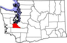 | |
| Town | ||
| CDPs | ||
| Unincorporated communities | ||
| Indian reservation | ||
| Ghost town | ||
| Footnotes | ‡This populated place also has portions in an adjacent county or counties | |