Rochester, Pennsylvania
| Rochester, Pennsylvania | |
|---|---|
| Borough | |
|
Rochester's municipal building | |
 Location in Beaver County and state of Pennsylvania | |
| Coordinates: 40°42′11″N 80°17′0″W / 40.70306°N 80.28333°WCoordinates: 40°42′11″N 80°17′0″W / 40.70306°N 80.28333°W | |
| Country | United States |
| State | Pennsylvania |
| County | Beaver |
| Settled | 1799 |
| Incorporated | 1849 |
| Government | |
| • Type | Borough Council |
| • Mayor | Sam Scriva |
| Area | |
| • Total | 0.7 sq mi (2 km2) |
| Elevation | 810 ft (250 m) |
| Population (2010) | |
| • Total | 3,657 |
| • Density | 5,734.2/sq mi (2,214.0/km2) |
| Time zone | Eastern (EST) (UTC-5) |
| • Summer (DST) | EDT (UTC-4) |
| Zip code | 15074 |
| Area code(s) | 724 |

Rochester is a borough in Beaver County, Pennsylvania, United States. Located 25 miles (40 km) northwest of Pittsburgh, it is part of the Pittsburgh metropolitan area. The population was 3,657 at the 2010 census.
Like many places in and around Pittsburgh and especially Beaver County, Rochester has been used for scenes in movies. Scenes in the 1986 movie Gung Ho (starring Pittsburgh native Michael Keaton), the 1996 movie Kingpin (starring Woody Harrelson, Randy Quaid, and Bill Murray), and the 2000 movie "Wonder Boys" (starring Michael Douglas, Tobey Maguire, and Robert Downey Jr.) were shot in Rochester.
History

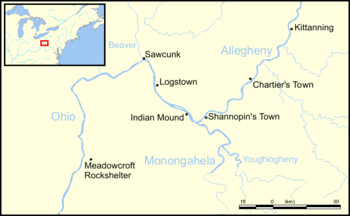
What would eventually become Rochester was originally a Lenape village called Sawcunk before being settled in 1799 in what was then the American frontier by white settlers. During this time, what would eventually become Rochester was known as East Bridgewater, Fairport, and Beaver Point. The borough adopted its current name in 1834 when a local businessman who did regular business in Pittsburgh decided to christen his home with the name Rochester so he could have a unique name to stamp his goods; the borough would officially be incorporated as such in 1849.[1]
Many of the streets that run through Rochester today had different names based on wild animals. Virginia Avenue and Adams Street—two of the cities main thoroughfares via Pennsylvania Route 68—were once known as Fox Lane and Tiger Lane, respectively. Deer Lane, which still exists today, is the last remnant of the original naming scheme for the street grid in the borough.[1]
Rochester is where Henry Clay Fry and his associates formed a glass manufacturing company following Fry's return from the American Civil War. In 1897 the Rochester Tumbler Company (as the company was known) became the National Glass Company of Rochester.[2][3] The company helped to revolution glass production by investing a new method for cutting glass by pressing it into a mold where previously the technique of cut glass had only been to blow it by hand.[4] At its height, the National Glass Company of Rochester employed over a 1000 people but its bankruptcy during the Great Depression began a long decline in the town's population which continues up to today.
Rochester was a railroad junction for the Pennsylvania Railroad and sat along the railroad's mainline from the Eastern United States to Chicago.
Geography
Rochester is at 40°42′11″N 80°17′0″W / 40.70306°N 80.28333°W (40.703146, -80.283420).[5]
According to the United States Census Bureau, the borough has a total area of 0.7 square miles (1.8 km2), of which, 0.6 square miles (1.6 km2) of it is land and 0.1 square miles (0.26 km2) of it (17.14%) is water.
Demographics
| Historical population | |||
|---|---|---|---|
| Census | Pop. | %± | |
| 1850 | 993 | — | |
| 1860 | 1,376 | 38.6% | |
| 1870 | 2,091 | 52.0% | |
| 1880 | 2,552 | 22.0% | |
| 1890 | 3,649 | 43.0% | |
| 1900 | 4,688 | 28.5% | |
| 1910 | 5,993 | 27.8% | |
| 1920 | 6,957 | 16.1% | |
| 1930 | 7,726 | 11.1% | |
| 1940 | 7,441 | −3.7% | |
| 1950 | 7,197 | −3.3% | |
| 1960 | 5,952 | −17.3% | |
| 1970 | 4,819 | −19.0% | |
| 1980 | 4,759 | −1.2% | |
| 1990 | 4,156 | −12.7% | |
| 2000 | 4,014 | −3.4% | |
| 2010 | 3,657 | −8.9% | |
| Est. 2015 | 3,569 | [6] | −2.4% |
| Sources:[7][8][9] | |||
As of the census[8] of 2000, there were 4,014 people, 1,732 households, and 971 families residing in the borough. The population density was 6,861.5 inhabitants per square mile (2,626.8/km²). There were 1,900 housing units at an average density of 1,243.4 persons/km² (3,247.8 persons/mi²). The racial makeup of the borough was 83.81% White, 13.38% African American, 0.22% Native American, 0.20% Asian, 0.57% from other races, and 1.82% from two or more races. Hispanic or Latino of any race were 0.92% of the population.
There were 1,732 households, out of which 25.6% had children under the age of 18 living with them, 37.3% were married couples living together, 14.7% had a female householder with no husband present, and 43.9% were non-families. 37.4% of all households were made up of individuals, and 14.7% had someone living alone who was 65 years of age or older. The average household size was 2.22 and the average family size was 2.97.
In the borough the population was spread out, with 21.6% under the age of 18, 9.1% from 18 to 24, 29.0% from 25 to 44, 22.3% from 45 to 64, and 17.9% who were 65 years of age or older. The median age was 39 years. For every 100 females there were 85.5 males. For every 100 females age 18 and over, there were 80.3 males.
The median income for a household in the borough was $30,970, and the median income for a family was $39,805. Males had a median income of $28,906 versus $21,576 for females. The per capita income for the borough was $15,359. About 7.2% of families and 12.2% of the population were below the poverty line, including 14.4% of those under age 18 and 11.1% of those age 65 or over.
Notable people
- Lauryn Williams, 2005 100m World champion sprinter and Olympic gold medalist and silver medalist
- Vito "Babe" Parilli, All Star quarterback of the Boston Patriots' "Team of the 1960s"
- Mark Grater, Major League Baseball player
- Kris Griffin, Kansas City Chiefs and Cleveland Browns linebacker
- Kirby Griffin, American football player
- Christina Aguilera, Grammy award winning pop music singer
- Mark Vlasic, American football quarterback
- Mickey Davis, basketball player
- Barney Cable, NBA Basketball Player 1958-1964
- Major General Joseph Henry Pendleton, war veteran after whom Marine Corps Base Camp Pendleton was named
See also
References
| Wikimedia Commons has media related to Rochester, Pennsylvania. |
- 1 2 The Hub: Rochester’s formative days were once part of East Bridgewater The Beaver County Times (07/14/2015)
- ↑ "HC Fry Glass Co.". Retrieved 2008-08-31.
- ↑ "H. C. Fry Glass Company Advertisements". Archived from the original on September 22, 2008. Retrieved 2008-08-31.
- ↑ Kane, p. 211 The glass was pressed into a mold, the marks of the iron plunger remaining on the inside of the glass. Previously, cut glass had been blown by hand.
- ↑ "US Gazetteer files: 2010, 2000, and 1990". United States Census Bureau. 2011-02-12. Retrieved 2011-04-23.
- ↑ "Annual Estimates of the Resident Population for Incorporated Places: April 1, 2010 to July 1, 2015". Retrieved July 2, 2016.
- ↑ "Census of Population and Housing". U.S. Census Bureau. Retrieved 11 December 2013.
- 1 2 "American FactFinder". United States Census Bureau. Retrieved 2008-01-31.
- ↑ "Incorporated Places and Minor Civil Divisions Datasets: Subcounty Resident Population Estimates: April 1, 2010 to July 1, 2012". Population Estimates. U.S. Census Bureau. Retrieved 11 December 2013.
Municipalities and communities of Beaver County, Pennsylvania, United States | ||
|---|---|---|
| Cities | 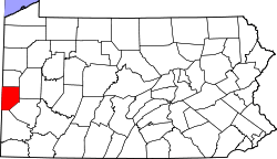 | |
| Boroughs |
| |
| Townships | ||
| Unincorporated communities | ||
| Footnotes | ‡This populated place also has portions in an adjacent county or counties | |
| Counties |  Map of the Pittsburgh Tri-State with green counties in the metropolitan area and yellow counties in the combined area. | |
|---|---|---|
| Major cities | ||
| Cities and towns 15k-50k (in 2010) | ||
| Airports | ||
| Topics | ||
| ||