Roburent
| Roburent | |
|---|---|
| Comune | |
| Comune di Roburent | |
|
Roburent in winter | |
 Roburent Location of Roburent in Italy | |
| Coordinates: 44°19′N 7°53′E / 44.317°N 7.883°ECoordinates: 44°19′N 7°53′E / 44.317°N 7.883°E | |
| Country | Italy |
| Region | Piedmont |
| Province / Metropolitan city | Province of Cuneo (CN) |
| Frazioni | Cardini, Pra, San Giacomo |
| Government | |
| • Mayor | Bruno Vallepiano (lista civica; elected 14 June 2004, re-elected 8 June 2009) |
| Area | |
| • Total | 29.9 km2 (11.5 sq mi) |
| Elevation | 788 m (2,585 ft) |
| Population (1 January 2009)[1] | |
| • Total | 552 |
| • Density | 18/km2 (48/sq mi) |
| Demonym(s) | Roburentesi |
| Time zone | CET (UTC+1) |
| • Summer (DST) | CEST (UTC+2) |
| Postal code | 12080 |
| Dialing code | 0174 |
| Website | www.comune.roburent.cn.it |

Roburent (Italian pronunciation: [robuˈrɛnt]) is a comune (commune or municipality) of the Province of Cuneo in the Italian region Piedmont. It is located about 80 kilometres (50 mi) south of Turin and about 30 kilometres (19 mi) southeast of Cuneo. As of 1 January 2009 its population was 552. The comune extends over a largely wooded area of 29.9 km2 (11.5 sq mi) ranging in elevation from 580 to 1,819 metres (1,903 to 5,968 ft) above sea-level and straddling the Corsaglia and Casotto valleys.[2][3][4] It borders the municipalities of Frabosa Soprana, Garessio, Montaldo di Mondovì, Ormea, Pamparato, and Torre Mondovì.
Population centres and trends
There are two main centres of population within the municipal boundaries. Roburent itself, which stands at 788 metres (2,585 ft) above sea-level, is the capoluogo and site of the municipal administration; it had 183 inhabitants at the time of the 2001 census. San Giacomo at 1,011 metres (3,317 ft) had a resident population of 247. Istat identified Pra (1014 m, pop. 12) as the third well-defined ‘populated centre’ (centro abitato). There were also eight minor settlements classified as ‘populated nuclei’ (nuclei abitati): Cardini (1153 m, pop. 35), Costacalda (1135 m, pop. 6), Mondini (920 m, pop. 14), Montà (780 m, pop. 12), Mottoni (964 m, pop. 2), Nasi (850 m, pop. 9), Patelle (1114 m, pop. 7), and Zitella (800 m, pop. 8).[2]
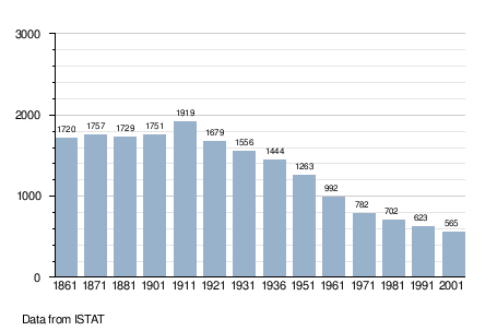
Since the First World War there has been a steady decline in the population of the comune, from a maximum of 1919 in 1911 to 552 at the start of 2009. The following graph is based on figures from the official censuses which have taken place since the unification of Italy.[5]
References
- ↑ ‘Popolazione residente al 1 Gennaio 2009 per età, sesso e stato civile: Comune di Roburent’, Istat, 2009.
- 1 2 ‘Tavola: Popolazione residente - Cuneo (dettaglio loc. abitate) - Censimento 2001’, 2001 Census, Istat.
- ↑ "Istat.it - English website". Istat. Retrieved December 4, 2009.
- ↑ Storia, Pro Loco Roburent.
- ↑ Unfortunately the source given is too imprecise to determine whether the figures have been adjusted in order to take account of any boundary changes which may have taken place since 1861.
External links
![]() Media related to Roburent at Wikimedia Commons
Media related to Roburent at Wikimedia Commons
- Historical notes on San Giacomo di Roburent and adjacent settlements from the site of the Associazione culturale Savin. (Italian)