Roaring Mountain
| Roaring Mountain | |
|---|---|
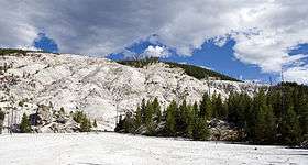 Roaring Mountain in 2010 | |
| Highest point | |
| Elevation | 8,152 ft (2,485 m) [1] |
| Coordinates | 44°46′38″N 110°43′39″W / 44.77722°N 110.72750°WCoordinates: 44°46′38″N 110°43′39″W / 44.77722°N 110.72750°W [2] |
| Geography | |
| Location | Teton County, Wyoming, U.S. |
| Parent range | Yellowstone Plateau |
| Topo map | USGS Obsidian Cliff, WY |
| Climbing | |
| Easiest route | hike |
Roaring Mountain (8,152 feet (2,485 m)) is in Yellowstone National Park in the U.S. state of Wyoming.[1] Roaring Mountain was named for the numerous fumaroles on the western slope of the peak which during the early 1900s were loud enough to be heard for several miles.[3] Roaring Mountain is 5 miles (8.0 km) north of Norris Geyser Basin and south of Obsidian Cliff and is easily seen from park roads.

Roaring Mountain displaying significant fumarole activity in this image by Ansel Adams taken in 1942
References
- 1 2 "Obsidian Cliff, WY" (Map). USGS Quad. TopoQuest. Retrieved 2011-02-12.
- ↑ "Roaring Mountain". Geographic Names Information System. United States Geological Survey. Retrieved 2011-02-12.
- ↑ "Roaring Mountain". Old Faithful Virtual Visitor Center. National Park Service. Retrieved 2011-02-12.
This article is issued from Wikipedia - version of the 1/1/2016. The text is available under the Creative Commons Attribution/Share Alike but additional terms may apply for the media files.