Rizal, Cagayan
| Rizal | ||
|---|---|---|
| Municipality | ||
 | ||
| ||
| Nickname(s): Malaueg | ||
| Motto: Rise Up Malaueg (Tanu napakesan nonta nasiksikan) | ||
 Map of Cagayan, showing the location of Rizal | ||
.svg.png) Rizal Location within the Philippines | ||
| Coordinates: 17°51′N 121°21′E / 17.85°N 121.35°ECoordinates: 17°51′N 121°21′E / 17.85°N 121.35°E | ||
| Country | Philippines | |
| Region | Cagayan Valley (Region II) | |
| Province | Cagayan | |
| District | 2nd District | |
| Founded | 1522 | |
| Barangays | 29 | |
| Government[1] | ||
| • Mayor | Joel A. Ruma | |
| Area[2] | ||
| • Total | 124.4 km2 (48.0 sq mi) | |
| Elevation (Mount Annaguan) | 1,400 m (4,600 ft) | |
| Population (2015 census)[3] | ||
| • Total | 17,994 | |
| • Density | 140/km2 (370/sq mi) | |
| Time zone | PST (UTC+8) | |
| ZIP code | 3526 | |
| IDD : area code | +63 (0)78 | |
| Income class | 5th class; rural | |
| Website |
www | |

Rizal is a fifth-class municipality in the province of Cagayan, Philippines. According to the 2015 census, it has a population of 17,994 people.[3]
Rizal, being on the border of Cagayan and Apayao provinces, has a cool climate similar to Baguio's. It attracts excursionists and vacationists anytime, especially in summer.
Rizal is home to Cagayan's legendary figures – Biuag and Malana – who were said to have fought their epic battle for supremacy over the hand of the beautiful "Maguinganay" by swapping volleys of uprooted trees and live cattle. Their hangouts, two high mountains and a steep trail called "escolta" from where they uprooted trees to hurl at one another, can still be seen in Malaueg (Rizal).
Local crops are corn, rice and tobacco. It is known before of its specie as "Matalag", which means men and women alike to go for its aroma and suaveness. Its bananas and mangoes have become a good source of revenue.
History
Spanish regime

The incorporation of the town was dated early 1500s during the Spanish era in the Philippines. At that time, the town was called "Malaueg". Spanish friars were converting the people to Christians. They became thirsty because of the unbearable heat of the sun and the mountainous terrain. Then one of the Malaueg people gave some water to them. The friar asked where the water came from and the man who gave the water uttered the word "ueg" that means fresh water. Then this friar had experienced a stomach pain that led him say "malo" which means bad. The word then finally combined and called as "MALO-UEG" that means bad brook. The name became permanently until 1903 when the town was renamed in the honor of the Philippine National Hero Dr. José Rizal.
During the Spanish regime, the town was said to be the rest spots of the Spanish Authorities, friars and some locals, because of its cool environmental climate. Malaueg people build the largest stone convents for the friars, some nipa hut houses for Spanish Authorities and some ordinary houses for the locals. Malaueg became a center of Christianity next to Nueva Segovia after the Malaueg Church was built.
American period
During the American occupation of the Philippines, the town of Malaueg was also a favorite spot for the Americans. During the Spanish–American War, the town was almost destroyed when the soldiers used its towering mountains to hide their ammunition and dug some trenches. The Authorities were very protective of the condition of the church during war.
The town before had two municipalities, namely: Mauanan and Malaueg. The barrios on the western and northern part belonged to the municipality of Malaueg, while the barrios on the eastern part belonged to the municipality of Mauanan, where the seat of two municipal governments was established (Philippine Commission; Act nos. 943,944, 1903). Act no. 2390 changed the names of the municipalities of Sto. Nino and Mauanan.
The names of the municipalities of Sto. Nino and Mauanan were changed to Faire and Rizal respectively. Mauanan was named Rizal in the year 1914 and the sitios of Lattut, Capacuaan and Macatal were annexed from Rippang in 1933, under executive Order No. 690 dated March 28, 1935.
Japanese occupation
During the Japanese occupation of the Philippines in World War II, the town was largely destroyed in bombing attacks. The town also became one of the centers of resistance in the Philippines because of its forested areas that served as a hideout.
Assassination
On December 3, 2008, elected mayor Raul dela Cruz sustained bullet wounds to the body and died while being taken to the hospital in Tuguegarao City.[4]
More violence took place on January 23, 2011, during the Town Fiesta, Police Commander Roweko and his wife together with six others were ambushed.
Geography
Rizal is located north-west of Tuguegarao City, which is 104 kilometres (65 mi) from the city. The place is hilly and mountainous. The poblacion is located on a plateau. The neighbouring barangays are situated on the slopes of hills and some are located along the banks of Matalag River.
The total land area of Rizal is 32,586.671 hectares (80,523.42 acres), of which 1000 hectares are built-up areas; 5545.0 hectares are agricultural land; 267.5 hectares for water bodies; 8375.1 hectares are open grassland; 207.0 hectares for roads and streets; 4.0 hectares for eco-tourism and 17,178.07 hectares (42,447.9 acres) are forest zones.
Mountains
- Mount Annaguan, the highest point in the town of Rizal, has the height of 1,400 metres (4,600 ft) and it can overview some neighboring towns from its peak.
- Mount Malaueg with a height of 1,093 metres (3,586 ft) is the mountain at the side of the town's capital.
- Mount Maoanan, with a height of 968.5 metres (3,177 ft), was the legendary mountain where Biuag and Malana fought a battle for a maguinganay.
The Sinicking National Park has the height of 801 metres (2,628 ft) and the highest elevation between the town's Poblacion and barangay Gaddangao is 1,004 metres (3,294 ft). The entrance to the town is very similar to the Kennon Road of Baguio City.
Barangays
Rizal is politically subdivided into 29 barangays.[2] (Figures stands for the list of Barangays and the elevation of each)
|
|
Demographics
| Population census of Rizal | ||
|---|---|---|
| Year | Pop. | ±% p.a. |
| 1990 | 12,478 | — |
| 1995 | 13,901 | +2.04% |
| 2000 | 14,929 | +1.54% |
| 2007 | 16,791 | +1.63% |
| 2010 | 18,592 | +3.78% |
| 2015 | 17,994 | −0.62% |
| Source: Philippine Statistics Authority[3][5] | ||
In the 2015 census, the population of Rizal, Cagayan, was 17,994 people,[3] with a density of 140 inhabitants per square kilometre or 360 inhabitants per square mile.
The local languages are Malaueg and Ilocano.
Local government

- Mayor: Joel A. Ruma
- Vice Mayor: Jhonas A. Ruma
- Councilors:
- Graciano Simon
- Marivic C. Littaua
- Bernabe D. Aday, Jr.
- Armando G. Gannaban
- Jose V. Dela Cruz
- Julio P. Orteza
- Judalyn Favor
- Battut J.Ingga
- Ex-Officio Members:
- Nelson S. Littaua (ABC Federation President)
- Romeo B. Dela Cruz, Jr. (SK Federation President)
Attractions
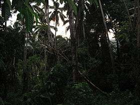
The tourism development includes the Alsung Cave, the Sinicking National Park and Mount Annaguan forest reservations that will serve as the home for the rare species exclusively found in the area.
- San Raimundo de Peñafort Church
- The church, also known as Malaueg Church, was built in 1597. It was under the patronage of St. Raymond of Penyafort. The Dominican fathers accepted the ecclesiastical administration of this town on April 26, 1590. The cornerstone was laid November 26, 1597. The church and the convent have been destroyed and rebuilt four times. A site visited by Roman Catholic pilgrims, believed to show luck to the people in the certain town.
- Alsung Cave
- A cave like a shape of a crocodile found in Mount. Annaguan.
- Sinicking National Park
- Still developing for tourism.
- Mount Malaueg
- The Eco-tourism mountain still developing for becoming a pure habitat for rare animal-plant species.
- Mount Annaguan
- The highest peak of the town that can view some places of the province of Cagayan.
- Ruins of an old oven can be seen at the lot of the late Capitan Domingo Littaua near the house of Martin Blaquera.
Transportation
The Cagayan–Apayao Road connects Rizal and nearby Conner to the neighboring towns of Tuao, Piat, Solana and Tuguegarao City. The 50 kilometres (31 mi) road from Tuao to Rizal is rough and can take up to one-half-hours. It will take another half-hour ride from Tuguegarao to Tuao.
The provincial road was opened in 1951. From 1951 to 1986, one had to cross the Matalag River with a ferry boat made out of bamboos and drum. The ferry boat loaded only one jeep or bus at a time. Traveling to Rizal from Tuao to Tuguegarao or vice versa in those days was slow and tiresome because it took the ferry boat almost an hour to ferry its load to and from the other side of the river. Vehicles were ferried on a first-come, first-served basis.
The roads to the town are along the edge of the mountain, having hairpin turns and in other barangays, the road is at the edge of the Matalag River and some are at the middle of the fields.
The following bus lines serve Rizal:
- Malaueg Bus Lines
- Duyun Lines
- Zinundungan Traveler
References
- ↑ "Official City/Municipal 2013 Election Results". Intramuros, Manila, Philippines: Commission on Elections (COMELEC). 11 September 2013. Retrieved 24 January 2014.
- 1 2 "Province: CAGAYAN". PSGC Interactive. Makati City, Philippines: National Statistical Coordination Board. Retrieved 24 January 2014.
- 1 2 3 4 "Region II (CAGAYAN VALLEY)". Census of Population (2015): Total Population by Province, City, Municipality and Barangay (Report). PSA. Retrieved 20 June 2016.
- ↑ http://newsinfo.inquirer.net/breakingnews/regions/view/20081204-175999/Cagayan-mayor-3-others-slain-in-ambush
- ↑ "Region II (CAGAYAN VALLEY)". Census of Population and Housing (2010): Total Population by Province, City, Municipality and Barangay (Report). NSO. Retrieved 29 June 2016.
External links
| Wikimedia Commons has media related to Rizal, Cagayan. |
 |
Kabugao, Apayao | Santo Niño | | |
| Conner, Apayao | |
Piat | ||
| ||||
| | ||||
| Conner, Apayao | Tuao |
Tuguegarao (capital) | |
| Municipalities | |
| Component city | |
| Barangays | |