Riverside Expressway
| Riverside Expressway Pacific Motorway Queensland | |
|---|---|
 | |
| General information | |
| Type | Expressway |
| Length | 2 km (1.2 mi) |
| Route number(s) |
|
| Former route number |
|
| Major junctions | |
| North end |
Brisbane City |
| South end |
Brisbane City |
| Highway system | |
|
Highways in Australia National Highway • Freeways in Australia Highways in Queensland | |
| |
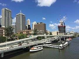
The Riverside Expressway is part of the Pacific Motorway that runs through Brisbane, Queensland, Australia. It is located on the western side of the Brisbane CBD and is made up of various bridges and overpasses. The North Bank development is proposed to alleviate the visual disruption of the expressway and recapture Brisbane for pedestrians.
The Expressway runs the entire western length of the Brisbane CBD from Coronation Drive to the Captain Cook Bridge at Gardens Point, an estimated 3 kilometres (1.9 mi) before becoming the Pacific Motorway which ends at the Gold Coast.
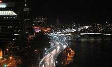
Congestion

Traffic congestion in the central city area became problematic in the late 1950s and 1960s. The Story Bridge, William Jolly Bridge and Victoria Bridge were clogged with traffic wanting to cross from one side of town to the other. A traffic engineering company called Wilbur Smith and Associates was asked to study Brisbane's traffic problems by the state government.[1] They delivered a report, the Brisbane Transportation Study, which included plans for traffic management for many years.
In 2016, the road was the most congested in the state with average traffic speeds in afternoon peak times slowing to 19 km per hour.[2]
History
Construction on the Riverside Expressway began in late 1968, when the pylons for the bridge were laid on the north bank of the Brisbane River. It was built over the former Short Street which provided access to a wharf.[3] The bridge was completed in 1975 as was the Southeast Freeway to Holland Park.[1] The Brisbane River was used as a source for gravel to make much of the concrete used in construction.
2006 appearance of cracks
During September and October 2006, roadworks occurred on the Expressway, and surrounding structures, including the Captain Cook Bridge. Maintenance on these structures had not been done since its construction in the 1970s. On 17 October 2006, parts of the expressway were closed due to safety concerns regarding hairline cracks in the Alice Street and Ann St ramps.
The initial conclusion reached by engineers is that the hairline fracture, measuring over 2 metres long and 0.4 mm wide, was caused by the stress on the structure due to "The weight of both ramps is [now] balanced on one bearing and they are failing to shift their weight to their other bearings as designed."[4]
This road closure caused widespread delays for motorists travelling through the inner city. Public transport facilities were heavily utilised to travel to work at peak periods. Business activity in the Brisbane central business district was affected by a dramatic reduction in customers as shoppers avoided the area.
On 20 October Department of Main Roads workers successfully drove a 22 tonne truck up and down the Ann Street ramp deeming the ramp to have passed a weight test. The main section of the Expressway was reopened, except for the Alice St. and Ann St. ramps. A few days later the ramps were completely reopened to all but heavy vehicles.
Major intersections and crossings
At the northern end the road start where North Quay ends at the intersection with Herschel Street. Nearby the road is crossed by the Kurilpa Bridge. Entrance and exits are provided for both Turbot Street and Ann Street. The Riverside Expressway is then crossed by the Victoria Bridge. Further south there are entrances and exits for Elizabeth Street, Margaret Street and Alice Street.
See also
References
- 1 2 Gregory, Helen; Dianne Mclay (2010). Building Brisbane's History: Structure, Sculptures, Stories and Secrets. Warriewood, New South Wales: Woodslane Press. pp. 8–10. ISBN 9781921606199.
- ↑ "Queensland's worst traffic crawl spots revealed". The Queensland Times. 29 April 2016. Retrieved 26 October 2016.
- ↑ Field, Noel D.; Annabelle Stewart-Zerba (2014). "The Long Story of the Short Street Wharf". Brisbane: Schemes and Dreams: Nineteenth Century Arrivals Volume 23 of Papers (Brisbane History Group). Boolarong Press. p. 151. ISBN 1925046990. Retrieved 28 October 2016.
- ↑ "Closure of sections of the Riverside Expressway and some onramps". Ministerial Media Statements. 17 October 2006.
External links
![]() Media related to Riverside Expressway at Wikimedia Commons
Media related to Riverside Expressway at Wikimedia Commons