Riverside, Illinois
| Riverside, Illinois | |
|---|---|
| Village | |
| Village of Riverside | |
|
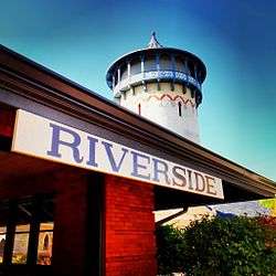
Riverside's Historic Water Tower and Train Station | |
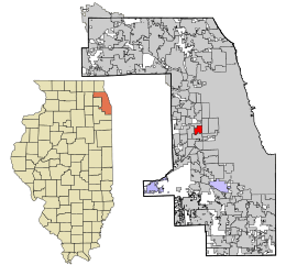 Location in Cook County and the state of Illinois. | |
.svg.png) Location of Illinois in the United States | |
| Coordinates: 41°49′51″N 87°48′58″W / 41.83083°N 87.81611°WCoordinates: 41°49′51″N 87°48′58″W / 41.83083°N 87.81611°W | |
| Country |
|
| State | Illinois |
| County | Cook |
| Township | Riverside |
| Incorporated | 1875 |
| Government | |
| • Type | Board of Trustees and Village President |
| • President | Benjamin Sells |
| Area | |
| • Total | 2.00 sq mi (5.2 km2) |
| • Land | 1.98 sq mi (5.1 km2) |
| • Water | 0.02 sq mi (0.05 km2) 1.00% |
| Population (2010) | |
| • Total | 8,875 |
| • Density | 4,482.3/sq mi (1,730.6/km2) |
| Down 0.22% from 2000 | |
| Standard of living (2007–11) | |
| • Per capita income | $46,334 |
| • Median home value | $397,200 |
| ZIP code(s) | 60546 |
| Area code(s) | 708 |
| Geocode | 54820 |
| Website |
www |
|
Riverside Landscape Architecture District | |
| Location | Bounded by 26th St., Harlem and Ogden Aves., the Des Plaines River, and Forbes Rd., Riverside, Illinois |
|---|---|
| Built | 1869 |
| Architect | Frederick Law Olmsted; Calvert Vaux |
| NRHP Reference # | 69000055[1] |
| Added to NRHP | September 15, 1969 |
Riverside is a suburban village in Cook County, Illinois, United States. A significant portion of the village is in the Riverside Landscape Architecture District, designated a National Historic Landmark in 1970.[2] The population of the village was 8,875 at the 2010 census.[3] It is a suburb of Chicago, located roughly 9 miles (14 km) west of downtown Chicago and 2 miles (3 km) outside city limits.
History
 | |
|
|
Riverside is arguably the first planned community in the United States, designed in 1869 by Calvert Vaux and Frederick Law Olmsted. The village was incorporated in 1875. The Riverside Landscape Architecture District, an area bounded by 26th Street, Harlem and Ogden avenues, the Des Plaines River, and Golf Road, was designated a National Historic Landmark in 1970.[5] In 1863 the Chicago, Burlington and Quincy Railroad was built heading southwest from downtown Chicago to Quincy, Illinois, passing through what is now the Near West Suburban area of Chicago in a western-southwestern direction. This new access to transportation and commerce brought about a significant housing and construction boom in what was once farmland far from the bustle of the city of Chicago.
In 1868, an eastern businessman named Emery E. Childs formed the Riverside Improvement Company, and purchased a 1,600-acre (6.5 km2) tract of property along the Des Plaines River and the Chicago, Burlington & Quincy Railroad line. The site was highly desirable due to its natural oak-hickory forest and its proximity to Chicago. The company commissioned well-known landscape architect Frederick Law Olmsted and his partner, Calvert Vaux, to design a rural bedroom community. The town's plan, which was completed in 1869, called for curvilinear streets, following the land's contours and the winding Des Plaines River. The plan also accorded for a central village square, located at the main railroad station, and a Grand Park system that uses several large parks as a foundation, with 41 smaller triangular parks and plazas located at intersections throughout town to provide for additional green spaces.[6]
The Great Chicago Fire of 1871 and the financial Panic of 1873 brought about the demise of the improvement company, bringing new construction nearly to a halt for some time. A village government was established in September 1875, and Olmsted's original development plan remained in force. Building resumed in the following years, with the opening of the Riverside Golf Club in 1893, the striking Chateauesque Riverside Township Hall in 1895, and the Burlington line train station in 1901. Many homes and estates were designed by architects such as Frank Lloyd Wright, Daniel Burnham, Louis Sullivan, William Le Baron Jenney, Frederick Clarke Withers, and Calvert Vaux at the time as well.[7]
A major period of residential development came again in the 1920s and late 1930s, when many modest houses were constructed on smaller parcels. The population grew to 7,935 by 1940 and consisted primarily of small proprietors, managers, and professionals who were predominantly of Anglo-American and German American background. The remaining residential areas were developed during the post–World War II boom, and by 1960 the village was almost entirely developed. The population peaked at 10,357 in 1970 and dropped below 8,500 by the mid-1990s.
Riverside has become an architectural museum, which is recognized by the village's National Historic Landmark designation. The village housing stock varies from well-maintained 1920s bungalows and huge Victorian and early-twentieth-century mansions that attract architectural tours led by The Frederick Law Olmsted Society of Riverside]. The charming village center houses several restaurants as well as coffee shops, and hosts stores selling antiques and Victorian house fixtures, reflective of the village's older affluent population.[8]
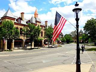 The Arcade Building and Riverside Township Hall
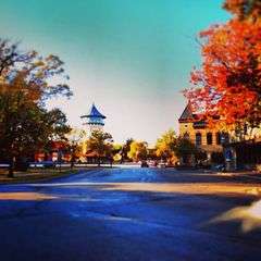 Looking at downtown Riverside from the Riverside Township Hall
Geography
Riverside is located at 41°49′51″N 87°48′58″W / 41.83083°N 87.81611°W (41.830881, -87.815981).[9] According to the 2010 census, Riverside has a total area of 1.998 square miles (5.17 km2), of which 1.98 square miles (5.13 km2) (or 99.1%) is land and 0.018 square miles (0.05 km2) (or 0.9%) is water.[10] Bordering suburbs include North Riverside to the north, Berwyn to the east, Stickney to the southeast, Lyons to the south, and Brookfield to the west. The Des Plaines River runs through the village along an area called Swan Pond.
Demographics
| Historical population | |||
|---|---|---|---|
| Census | Pop. | %± | |
| 1900 | 1,551 | — | |
| 1910 | 1,702 | 9.7% | |
| 1920 | 2,532 | 48.8% | |
| 1930 | 6,770 | 167.4% | |
| 1940 | 7,935 | 17.2% | |
| 1950 | 9,153 | 15.3% | |
| 1960 | 9,750 | 6.5% | |
| 1970 | 10,357 | 6.2% | |
| 1980 | 9,236 | −10.8% | |
| 1990 | 8,774 | −5.0% | |
| 2000 | 8,895 | 1.4% | |
| 2010 | 8,875 | −0.2% | |
| Est. 2015 | 8,835 | [11] | −0.5% |
| Demographics (2010)[3] | |||
|---|---|---|---|
| White | Black | Asian | |
| 91.3% | 1.3% | 2.1% | |
| Islander | Native | Other | Hispanic (any race) |
| 0.03% | 0.2% | 5.0% | 10.5% |
As of the census[13] of 2000, there were 8,895 people, 3,552 households, and 2,436 families residing in the village. The population density was 4,509.1 people per square mile (1,743.3/km²). There were 3,668 housing units at an average density of 1,859.4 per square mile (718.9/km²). The racial makeup of the village was 95.38% White, 0.26% African American, 0.08% Native American, 1.60% Asian, 0.01% Pacific Islander, 1.57% from other races, and 1.10% from two or more races. Hispanic or Latino of any race were 5.50% of the population.
The top five ancestries reported in Riverside as of the 2000 census were Irish (20.8%), Polish (18.4%), German (17.7%), Italian (13.8%) and Czech (8.0%).[14]
There were 3,552 households out of which 30.9% had children under the age of 18 living with them, 57.4% were married couples living together, 8.5% had a female householder with no husband present, and 31.4% were non-families. 27.4% of all households were made up of individuals and 9.8% had someone living alone who was 65 years of age or older. The average household size was 2.49 and the average family size was 3.08.
In the village the age distribution of the population shows 23.9% under the age of 18, 5.9% from 18 to 24, 28.2% from 25 to 44, 26.6% from 45 to 64, and 15.4% who were 65 years of age or older. The median age was 40 years. For every 100 females there were 92.7 males. For every 100 females age 18 and over, there were 88.2 males.
The median income for a household in the village was $64,931, and the median income for a family was $80,146. Males had a median income of $56,808 versus $36,349 for females. The per capita income for the village was $34,712. About 1.8% of families and 3.0% of the population were below the poverty line, including 2.2% of those under age 18 and 5.1% of those age 65 or over.
Government
Riverside is mostly in Illinois's 4th congressional district, with a small portion in Illinois's 3rd congressional district.[15]
The United States Postal Service operates the Riverside Post Office at 45 East Burlington Street and the North Riverside Post Office at 7300 West 25th Street.[16][17]
Education
Riverside is served by District 96 for public schools. District 96 has 4 elementary schools, and one junior high school. High school District 208 serves Riverside high school students.
The elementary schools are:
- Central Elementary School located at 61 Woodside Road
- Ames School located at 86 Southcote Road
- Blythe Park School located at 735 Leesley Road
- Hollywood School (in Brookfield) located at 3423 Hollywood Avenue
The middle school is:
- L. J. Hauser Junior High School located at 65 Woodside Road
The high school is:
- Riverside Brookfield High School, locally known as RB, is located at 160 Ridgewood Road
Private schools include:
- Riverside Presbyterian Pre-School
- St. Paul's Building Blocks Pre-School
- St. Mary Catholic Elementary School
- Tallgrass Sudbury School
Transportation
Riverside is served by the BNSF Railway Line with a station at Riverside. The Hollywood and Harlem Avenue stations are nearby.
Notable people
- Robert Todd Lincoln Beckwith, last descendant of Abraham Lincoln
- Patrick Creadon, filmmaker
- Jean Fenn, opera singer
- George Hunt, Illinois Attorney General
- Johnny "Red" Kerr, center and power forward with the Philadelphia 76ers and Baltimore Bullets; coach with the Chicago Bulls and Phoenix Suns; longtime Bulls broadcaster
- Tom Kondla, center with the Minnesota Pipers and Houston Mavericks
- "Screwy" Claude Maddox, criminal ally of Al Capone
- Martin E. Marty, scholar of religion
- Frank Nitti, criminal ally of Capone
- Judy Baar Topinka, state politician; Illinois State Comptroller and Illinois State Treasurer
Popular culture
- Parts of the movie The Lake House were filmed at the Riverside train station, the former Henninger's Pharmacy, and at the Sidney Allen home at 84 Riverside Road.
- The made-for-TV movie In the Company of Darkness was filmed throughout Riverside.
- The 2004 movie Christmas with the Kranks took place in Riverside, although it was filmed in California and Canada.
Business
The Central Business District, located around the Riverside Metra station, has a collection of shops, several cafes, banks, and wealth management offices. The Central Business District is also home to Riverside Foods, a long-standing neighborhood grocery store that offers fresh meat, produce, bakery, and beer, wine and liquor.
See also
- Garden city movement
- Garden real estate
- Riverside (Metra)
- Riverside Historic District (Riverside, Illinois)
References
- ↑ National Park Service (2006-03-15). "National Register Information System". National Register of Historic Places. National Park Service.
- ↑ "Riverside Historic District". National Historic Landmarks Quicklinks. National Park Service. Retrieved 18 March 2012.
- 1 2 "Profile of General Population and Housing Characteristics: 2010 Demographic Profile Data (DP-1): Riverside village, Illinois". U.S. Census Bureau, American Factfinder. Retrieved March 19, 2013.
- ↑ "10 Towns that Changed America". WTTW. April 19, 2016. Retrieved April 22, 2016.
- ↑ National Register Information System. Accessed 2009-11-03.
- ↑ The Riverside Museum. Accessed 2009-11-03.
- ↑ The Village of Riverside. Accessed 2009-11-03.
- ↑ Encyclopedia of Chicago. Accessed 2009-11-03.
- ↑ "US Gazetteer files: 2010, 2000, and 1990". United States Census Bureau. 2011-02-12. Retrieved 2011-04-23.
- ↑ "G001 - Geographic Identifiers - 2010 Census Summary File 1". United States Census Bureau. Retrieved 2015-12-25.
- ↑ "Annual Estimates of the Resident Population for Incorporated Places: April 1, 2010 to July 1, 2015". Retrieved July 2, 2016.
- ↑ "Census of Population and Housing". Census.gov. Retrieved June 4, 2015.
- ↑ "American FactFinder". United States Census Bureau. Retrieved 2008-01-31.
- ↑ "Profile of General Demographic Characteristics, Riverside, Illinois" (PDF). (38.9 KiB). U.S. Census Bureau. Accessed 2007-04-05.
- ↑ "Congressman Daniel Lipinski." Dan Lipinski Representing the 3rd District of Illinois. Retrieved on June 18, 2009.
- ↑ "Post Office Location - NORTH RIVERSIDE." United States Postal Service. Retrieved on April 17, 2009.
- ↑ "Post Office Location - RIVERSIDE." United States Postal Service. Retrieved on April 17, 2009.
External links
- Village of Riverside official website
- The Frederick Law Olmsted Society of Riverside
- Riverside community website