River Wyre

The River Wyre is a river in Lancashire, United Kingdom, which flows into the Irish Sea at Fleetwood. It is approximately 28 miles (45 km) in length. The river is a County Biological Heritage Site.
Geography
The river rises in the Forest of Bowland in central Lancashire, as two distinct tributaries, the Tarnbrook Wyre and the Marshaw Wyre, whose confluence is near the village of Abbeystead. In 1984 a pumping station, built just below the confluence as part of a water transfer scheme in the 1980s, was the location of the Abbeystead disaster, an explosion in which 16 people were killed and a further 22 were injured.
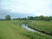
From Abbeystead, the river flows south through Dolphinholme to Garstang, where the Lancaster Canal crosses on a small aqueduct. One mile south, at Catterall, it meets its first major tributary, the River Calder. The river then turns westwards, flowing through St Michael's On Wyre where it is joined by its second major tributary, the River Brock. It becomes tidal below the weir at St Michael's.
It is crossed by a toll bridge (normal fee is 50 pence) at Cartford, between Little Eccleston and Out Rawcliffe. A former toll bridge, Shard Bridge, close to Poulton-le-Fylde, has been rebuilt and is now free. A pedestrian ferry runs between Fleetwood and Knott End but the ferry to the Isle of Man no longer runs.
Major industry existed at the former ICI site at Burn Naze, close to the estuary of the river. It was originally an alkali works taking brine from mines and wells across the river in and around Preesall. Later processes undertaken on the site included those dealing with Vinyl Chloride Monomer, although this was later moved to Runcorn and ICI activity on the site ceased. Industrial activity by a number of various companies continues by the river, albeit on a much reduced scale.
The area around Burn Naze on the western side of the Wyre Estuary was formerly known as Bergerode, believed to be an Old English term for "shallow harbour", beor grade.[1]
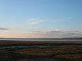
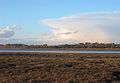
From Skippool, just downstream of Shard Bridge, to Fleetwood, the banks of the river form the Wyre Estuary Country Park. Facilities exist on the western bank. The park has its headquarters at Stanah. It has been the recipient of a Green Flag Award.
Fleetwood at the mouth of the river was a major fishing port up until the latter part of the 20th century. Wyre Dock was built there between 1869 and 1877. With the decline in the size of the fleet, most of the dock complex has subsequently been converted to a marina and the adjacent "Freeport" shopping village.
The river drains a total catchment area of approximately 175 square miles (450 km²). The tidal portion of the river below Cartford Bridge drains a catchment area of approximately 125 square miles (320 km2).[2]
The Wyre is reputedly the longest river in England whose estuary can be seen from its source.
The river's name possibly means 'winding river' in Celtic.[3]

Settlements
River Wyre

- Fleetwood
- Knott End-on-Sea
- Stanah
- Thornton
- Hambleton
- Skippool
- Little Singleton
- Out Rawcliffe
- Little Eccleston
- Great Eccleston
- St Michael's on Wyre
- Churchtown
- Catterall
- Garstang
- Cabus
- Scorton
- Hollins Lane
- Dolphinholme
- Abbeystead
Marshaw Wyre
- Marshaw
Tarnbrook Wyre
- Lower Lee
- Tarnbrook
Tributaries
River Wyre
- Hillylaid Pool
- Wardley's Pool
- Peg's Pool
- Skippool Creek
- Main Dyke
- Lucas Flash
- Main Dyke
- Calder Brook
- Wall Mill Pool
- Thistleton Brook
- Medlar Brook
- Scholar Brook
- Thistleton Brook
- River Brock
- Yoad Pool
- New Draught
- Old River Brock
- Bacchus Brook
- Bull Brook
- Withney Dike
- Woodplumpton Brook
- Swill Brook
- Blundel Brook
- New Mill Brook
- Barton Brook
- Dean Brook
- Sparling Brook
- Factory Brook
- Westfield Brook
- Mill Brook
- Whinnyclough Brook
- Bullsnape Brook
- Whinnyclough Brook
- Mill Brook
- Barton Brook
- Old River Brock
- Blay Brook
- Lickhurst Brook
- Huds Brook
- Winsnape Brook
- Clough Heads Brook
- Longback Brook
- Ains Pool
- River Calder
- Little Calder River
- Nanny Brook
- Calder Dyke
- East Grain
- North Grain
- Parkhead Brook
- Grizedale Brook
- Oxen Beck
- Tithe Barn Brook
- Park Brook
- Foxhouses Brook
- Lordshouse Brook
- Street Brook
- Damas Gill
- Sparrow Gill
- Caw Brook
- Smithy Beck
- Gallows Clough
- Hall Gill
- Parson's Brook
- Joshua's Beck
- Cam Brook
- Lainsley Slack
Marshaw Wyre
- Marshaw Wyre
- Inchaclough
- White Syke
- Bull Beck
- Well Brook
- Meer Brook
- Black Clough
- Tail Clough
- Trough Brook
- Threapshaw Clough
Tarnbrook Wyre
- Tarnbrook Wyre
- River Grizedale
- Castle Syke
- Grizedale Brook
- Lower Within Syke
- Higher Within Syke
- Wood Syke
- Stick Close Beck
- Thorn Clough
- Fall Clough
- Tarn Syke
- Thrush Clough
- Higher Syke
- Delph Beck
- White Moor Clough
- Swine Clough
- Deer Clough
- Small Clough
- Gavells Clough
- Hare Syke
- River Grizedale
Notes
- ↑ William John Thomas et al., Notes and Queries (1850). Oxford University Press.
- ↑ "Wyre Catchment Area Flood Management Plan" (PDF). Environment Agency. January 2007. Retrieved 2007-10-25.
- ↑ Reaney, P. H. (1964). The Origin Of English Place-Names. Routledge and Keagan Paul. p. 80.
Coordinates: 53°55′23″N 3°00′23″W / 53.92301°N 3.00649°W
External links
| Wikimedia Commons has media related to River Wyre. |
- The River Wyre in Garstang
- A great sea fishing venue the Wyre estuary is a favourite of local sea angling clubs
| Rivers | |
|---|---|
| Canals | |
| Others | |