River Ray, Wiltshire
This article is about the River Ray in Wiltshire. For the River Ray in Buckinghamshire and Oxfordshire, see River Ray.
| River Ray, Wiltshire | |
| River | |
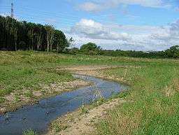 River Ray new meandering channel at Rivermead, Swindon, Wiltshire. | |
| Country | England |
|---|---|
| Counties | Wiltshire |
| Towns | Swindon |
| Source | |
| - location | Wroughton, Wiltshire |
| - coordinates | 51°31′24″N 1°47′29″W / 51.52333°N 1.79139°W |
| Mouth | River Thames |
| - location | Cricklade |
| - coordinates | 51°38′39″N 1°49′20″W / 51.64417°N 1.82222°WCoordinates: 51°38′39″N 1°49′20″W / 51.64417°N 1.82222°W |
| Discharge | for Water Eaton, Wiltshire |
| - average | 1.28 m3/s (45 cu ft/s) |
| - max | 32.2 m3/s (1,137 cu ft/s) 27 September 1974 |
| - min | 0.26 m3/s (9 cu ft/s) 28 August 1976 |
The River Ray is a tributary of the River Thames in England which flows through Wiltshire.
The river rises at Wroughton to the south of Swindon and runs to the west of the town via Shaw.[1] It joins the Thames on the southern bank near Cricklade just upstream of Water Eaton House Bridge. The river has been subject to a restoration project run by the Wiltshire Wildlife Trust. The final stage, completed in December 2007, was to build a tunnel near the Great Western Way at Rivermead to allow the nine species of fish to travel the length of the river without obstruction.[2]
See also
References
- ↑ Fred. S Thacker The Thames Highway Vol II Locks and Weirs 1920
- ↑ BBC News 16 December 2007 Tunnel allows fish to swim freely
| Next confluence upstream | River Thames | Next confluence downstream |
| River Key (south) | River Ray, Wiltshire | River Coln (north) with Thames and Severn Canal |
This article is issued from Wikipedia - version of the 6/16/2016. The text is available under the Creative Commons Attribution/Share Alike but additional terms may apply for the media files.