River Og
| Og | |
| River | |
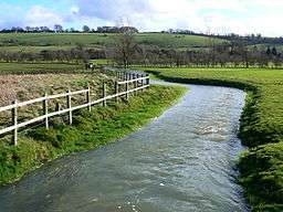 River Og, near Ogbourne St Andrew. | |
| Country | United Kingdom |
|---|---|
| Region | Wiltshire |
| Source | |
| - location | Draycot Foliat, Swindon, United Kingdom |
| - coordinates | 51°29′53″N 1°44′25″W / 51.49806°N 1.74028°W |
| Mouth | |
| - location | Marlborough, Wiltshire, United Kingdom |
| - coordinates | 51°25′13″N 1°43′43″W / 51.42028°N 1.72861°WCoordinates: 51°25′13″N 1°43′43″W / 51.42028°N 1.72861°W |
The River Og is a short river in Wiltshire, England.
It rises near the hamlet of Draycot Foliat, and flows south through Ogbourne St George, Ogbourne St Andrew and Ogbourne Maizey to Marlborough, where it joins the River Kennet.
The river flows through a gap in the Marlborough Downs which creates a natural transport route, now followed by the A346 and once used by the Midland and South Western Junction Railway.
The name is a back-formation from Ogbourne (which itself means Occa's stream).[1]
References
- ↑ Glover, J.E.B., Mawer, A. and Stenton, F.M. (1939) Place-names of Wiltshire, p.9
| Unitary authorities | |
|---|---|
| Major settlements | |
| Rivers | |
| Topics | |
This article is issued from Wikipedia - version of the 6/15/2016. The text is available under the Creative Commons Attribution/Share Alike but additional terms may apply for the media files.