River Lee
| River Lee | |
|---|---|
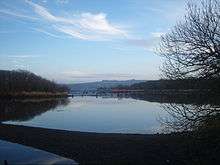 The Gearagh is a submerged woodland situated on the Lee near Macroom | |
| Basin | |
| Main source | Shehy Mountains near Gougane Barra |
| River mouth | Celtic Sea at Cork Harbour mouth |
| Basin size | 1,253.5 km2 (484.0 sq mi)[1] |
| Physical characteristics | |
| Length | 90 km (56 mi)[1] |
| Discharge |
|
The River Lee (Irish: An Laoi) is a river in Ireland. It rises in the Shehy Mountains on the western border of County Cork and flows eastwards through Cork, where it splits in two for a short distance, creating an island on which Cork's city centre is built, and empties into the Celtic Sea at Cork Harbour on the south coast, one of the largest natural harbours in the world. The catchment area of the River Lee is 1,253 km2.[3] The long-term average flow rate of the River Lee is 40.4 Cubic Metres per second (m3/s)[3]
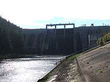
A hydro-electric scheme was built on the river, upstream from Cork City, and this part of the river now contains the Carrigadrohid and Inniscarra reservoirs. The river is crossed by 42 bridges, 29 of which are in Cork City, and one tunnel. The river also provides an 8 kilometres (5.0 mi) stretch of salmon fishing.
Description
Sources
The River Lee has its source in the Shehy Mountains near Gougane Barra, where there is a forest park, chapel, hotel, and shop.
Course

The Lee flows from the lake of Gougane Barra as a fast paced torrent, but by the town of Ballingeary it eases and flows into Lough Allua. Departing the lough, running east, it again becomes a rapid flow before running into the Inniscarra reservoir created by Inniscarra Dam. Moving on, it flows down from the dam, in normal conditions a gentle river until it comes to Ballincollig Weir in Ballincollig Park; here it is dangerous to swimmers when in high water. The Lee then flows into the city under Inniscarra Bridge and flows parallel to the Carrigrohane road. Along this section gauges monitor the water levels from the Inniscarra Dam. The river flows over the Lee weir and then is split into the north and south channel at a sluice (it historically occupied the city area in a maze of channels). This area is popular for recreation, kayaking and fishing. The two channels join again at the Cork docks and enter the extensive estuary and harbour, south of Glanmire, passing either side of Great Island (Cobh lies on the south coast) to fill the outer harbour, and reaching the open sea between Whitegate and Crosshaven.
Tributaries
The upper tributaries of the Lee include the large Sullane River from near Ballyvourney (tributaries include the Foherish and Laney Rivers), the small Buinea and Glashagariff Rivers, the River Dripsey and its tributary the Ryelane, the River Bride from Crookstown via Ovens, and the Shournagh River (formed from the Blarney and Martin Rivers, and the Owennagearagh River; historically may have been the Awbeg River). City area tributaries include the combined Maglin (from Ballincollig) and Curraheen (occasionally Curragheen) Rivers, capturing the Glasheen River also and joining at the western end of the UCC complex, and the Kiln River which joins by the Christy Ring Bridge in the city centre, a little west of St. Patrick's Bridge[4] (formed in turn from another Bride River and the Kilnap or Glennamought River, later joined by the Glen River). Estuarine tributaries include Glashaboy River, passing Glanmire (main tributaries the Black Brook, Cloghnageshee River and Butterstown River), the Douglas or Tramore River (joined by the Trabeg River as it flows into the Douglas Channel, its estuary) which drains parts of the southern city, Owennacurra River (joined by the Dungurney River at Midleton), and the Owenaboy River almost at the final mouth of the outer Lee estuary (the Liberty Stream joins this river, with significant flows from Cork Airport).[5]
Recreation
Recreation activities on the Lee include sailing, from a sailing club based on Inniscarra lake, where people also swim. There is a kayak club based on the Lee Road. Water skiing also takes place on Inniscarra lake and several rowing clubs are based on the Lee including the "Lee Rowing Club" and "Shandon Boat Club". Anglers are common at the banks of the Lee Fields.
Flooding
Tidal considerations, combined with low-lying urban developments, and later dam management contribute to repeated flooding events on the Lee.[6][7][8][9] For example, specific streets in Cork city centre have been affected by floods more than 100 times since the mid-19th century.[10]
In late 2009 the river flooded, causing some of the most significant damage in Cork city for a number of centuries. The Lee Water Station was forced to shut down after being submerged under six metres of water, and resulted in 40% of Cork City (50,000 people) being without running water for over one week. [11]
Lower-lying parts of the University College Cork campus were also flooded extensively, resulting in lectures being canceled throughout the week.[12] There was severe damage to the university's then newly built IT building, the Western Gateway Building, situated next to the river on a known floodplain, where for example a 300-seat auditorium was flooded to near ceiling height.[13]
To prevent issues upstream, the ESB made a controversial decision to release water from the Inniscarra hydro-electric dam. This released 535 tonnes of water per second into the already flooded river, raising the flood to 1.5 metres in parts of the city centre. The ESB insisted this was an essential move, and if water had not been released, the flooding would have been much worse.[14]
References
- 1 2 "Irishfisheries.com/waterways - River Lee". irishfisheries.com.
- ↑ http://www.serbd.com/MultiDownloads/Creport/Chapters/Physical%20Description%20Ch3.pdf
- 1 2 South Eastern River Basin District Management System. Page 38
- ↑ Insurance Plan of Cork (Goad Map), 1897, retrieved 2 Jan 2013 from Cork Past & Present - Goad Key
- ↑ Lee CFRAMS: Hydrology Report, Halcrow Group Ireland for the OPW, Cork: 2008
- ↑ http://www.opw.ie/en/leecframs/floodmaps/
- ↑ https://web.archive.org/web/20160508223553/http://www.lee.cfram.com/
- ↑ http://www.lee.cfram.com/downloads/documents/REP007_FinalReport.pdf
- ↑ http://www.lowerleefrs.ie/index.php/site/index
- ↑ http://www.corkpastandpresent.ie/places/oliverplunkettstreet/floodinginoliverplunkettstreet/
- ↑ "City facing bill of €100m to fix flood damage". Irish Independent. 2009-11-23. Retrieved 2010-01-27. Independent.ie's summary on the flood
- ↑ "University College Cork (UCC): Weather Notifications". Archived from the original on 24 November 2009. Retrieved 2010-01-27. UCC's Notification webpage on the floods
- ↑ "Report-on-Major-Flood-Damage.pdf" (PDF). Retrieved 2010-01-27. PDF file on the damages
- ↑ Riegel, Ralph; Melia, Paul (2009-12-08). "ESB stands by decision to release water into city centre". Irish Independent. Retrieved 2010-01-27. Independent.ie News article on ESB's decision
External links
| Wikimedia Commons has media related to River Lee (County Cork. |
Coordinates: 51°53′55″N 8°32′21″W / 51.89861°N 8.53917°W