River Bela
| River Bela | |
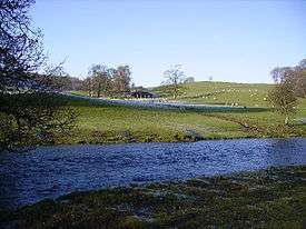 The Bela between Beetham and Milnthorpe | |
| Country | United Kingdom |
|---|---|
| Part | England |
| County | Cumbria |
| Source confluence | |
| - location | confluence of Peasey Beck and Stainton Beck at Overthwaite |
| Mouth | Confluence with River Kent |
| - coordinates | GB 54°13′37″N 2°47′14″W / 54.22707°N 2.78725°WCoordinates: GB 54°13′37″N 2°47′14″W / 54.22707°N 2.78725°W |
 Location within Cumbria | |
The River Bela is a short [approx. 6.5 km] river in the county of Cumbria, England. It is in the ancient county of Westmorland.
The river is formed by the confluence of Peasey Beck and Stainton Beck at Overthwaite. It runs through Beetham where it still powers the Heron Corn Mill, and formerly powered the Billerud paper mill. It then flows through the deer park of Dallam Tower before skirting around the south of the town of Milnthorpe and joining the River Kent estuary between Sandside and Milnthorpe.
At its mouth it was formerly crossed by the Sandside Viaduct on the Hincaster Branch Line railway from Arnside to Hincaster, demolished after the line was closed to passengers in 1942 and the track lifted in 1966.
During World War II a prisoner of war camp was built beside the river at grid reference SD513802. After the war the camp became an open prison, and there is now a residential school on the site.[1]