Ringvassøy
| Native name: <span class="nickname" ">Ráneš | |
|---|---|
 Map of Ringvassøy | |
| Geography | |
| Location | Northern Norway |
| Coordinates | 69°55′N 19°15′E / 69.917°N 19.250°ECoordinates: 69°55′N 19°15′E / 69.917°N 19.250°E |
| Area | 656 km2 (253 sq mi) |
| Length | 34 km (21.1 mi) |
| Width | 37 km (23 mi) |
| Highest elevation | 1,051 m (3,448 ft) |
| Highest point | Soltindan |
| Administration | |
|
Norway | |
| County | Troms |
| Municipalities | Karlsøy and Tromsø |
Ringvassøya (Northern Sami: Ráneš) is a large island in Troms county, Norway. It is divided between the municipalities of Tromsø and Karlsøy. Several islands surround Ringvassøya including Kvaløya to the south; Reinøya and Karlsøya to the east; Vannøya, Helgøya, and Nordkvaløya to the north; and Rebbenesøya to the north west.
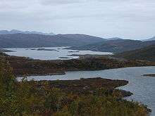
View of Skogsfjordvatn lake on Ringvassøya
With an area of 656 square kilometres (253 sq mi), Ringvassøy is the sixth largest island in mainland Norway. The island's highest point, Soltindan, has a height of 1,051 metres (3,448 ft) above sea level. The 10-kilometre (6.2 mi) long Skogsfjordvatnet is the largest lake on an island in Norway.[1]
References
- ↑ Store norske leksikon. "Ringvassøy" (in Norwegian). Retrieved 2010-04-06.
This article is issued from Wikipedia - version of the 7/21/2016. The text is available under the Creative Commons Attribution/Share Alike but additional terms may apply for the media files.