Rignano Flaminio
| Rignano Flaminio | |
|---|---|
| Comune | |
| Comune di Rignano Flaminio | |
|
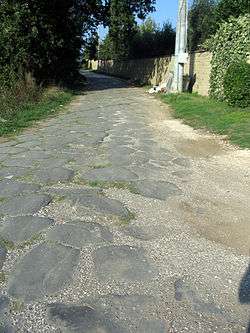
The ancient Via Flaminia. | |
 Rignano Flaminio Location of Rignano Flaminio in Italy | |
| Coordinates: 42°12′N 12°29′E / 42.200°N 12.483°E | |
| Country | Italy |
| Region | Latium |
| Province / Metropolitan city | Rome (RM) |
| Frazioni | Capannacce, Case Morolo, Montelarco, Santo Sisini, Valle Spadana |
| Government | |
| • Mayor | Ottavio Coletta |
| Area | |
| • Total | 38.77 km2 (14.97 sq mi) |
| Elevation | 250 m (820 ft) |
| Population (31 December 2012)[1] | |
| • Total | 10,311 |
| • Density | 270/km2 (690/sq mi) |
| Demonym(s) | Rignanesi |
| Time zone | CET (UTC+1) |
| • Summer (DST) | CEST (UTC+2) |
| Postal code | 00068 |
| Dialing code | 0761 |
| Website | Official website |
Rignano Flaminio is a comune (municipality) in the Metropolitan City of Rome in the Italian region Latium, located about 35 kilometres (22 mi) north of Rome. It is located across the Via Flaminia.
Rignano Flaminio borders the following municipalities: Calcata, Capena, Civitella San Paolo, Faleria, Magliano Romano, Morlupo, Sant'Oreste.
It has a station on the Roma-Viterbo railway.
History
Agricultural settlements of the Capenati and Falisci in the area are attested from the 5th/4th centuries BC. In the 6th century AD a popular pilgrimage church, entitled to St. Abondius and Abondantius, was created here; the saints' relics were moved to Rome, on the Tiber Island, in 999. In 1159 Pope Adrian IV died at Rignano.
Rignano was first a possession of Santa Maria in Trastevere, and then of the Savelli family, whom were shortly ousted by Pope Alexander VI. After the fall of the Borgia, the Savelli regained it, and hold the fief until 1607, when they sold it to the Borghese, later followed by the Muti, the Cesi and the Massimo families.