Richmond West, Florida
| Richmond West, Florida | |
|---|---|
| CDP | |
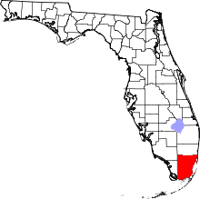
 Location in Miami-Dade County and the state of Florida | |
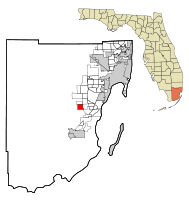
 U.S. Census Bureau map showing CDP boundaries | |
| Coordinates: 25°36′37″N 80°25′40″W / 25.61028°N 80.42778°WCoordinates: 25°36′37″N 80°25′40″W / 25.61028°N 80.42778°W | |
| Country |
|
| State |
|
| County | Miami-Dade |
| Area | |
| • Total | 4.3 sq mi (11 km2) |
| • Land | 4.2 sq mi (10.8 km2) |
| • Water | 0.1 sq mi (0.2 km2) |
| Elevation | 7 ft (2 m) |
| Population (2000) | |
| • Total | 28,082 |
| • Density | 6,530.7/sq mi (2,552.9/km2) |
| Time zone | Eastern (EST) (UTC-5) |
| • Summer (DST) | EDT (UTC-4) |
| FIPS code | 12-60230[1] |
| GNIS feature ID | 1853280[2] |
Richmond West is a census-designated place (CDP) in Miami-Dade County, Florida, United States. The population was 28,082 at the 2000 census.
Geography
Richmond West is located at 25°36′37″N 80°25′40″W / 25.610164°N 80.427836°W.[3]
According to the United States Census Bureau, the CDP has a total area of 4.3 square miles (11 km2), of which, 4.2 square miles (11 km2) of it is land and 0.1 square miles (0.26 km2) of it (2.11%) is water.
History
On September 15, 1945, the Homestead hurricane caused an estimated fifty million (then-year) dollars, impacting the area.[4] Nearly half of the financial loss happened at the Richmond Naval Air Station, where winds ignited a fire at three hangars, destroying 25 blimps, 366 planes, and 150 automobiles. Across the state, the passage of the hurricane resulted in 1,632 destroyed houses, with an additional 5,372 damaged. Four people were killed in the state, with an additional 43 injured.[5]
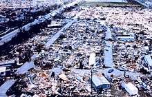
In August 1992, Dadeland Mobile Home park and the surrounding south Miami-Dade area were severely damaged by Hurricane Andrew. Many of the homes and businesses in the area were completely destroyed . In subsequent years, the area was gradually rebuilt.[6][7]
Demographics
As of the census[1] of 2000, there were 28,082 people, 7,833 households, and 7,175 families residing in the CDP. The population density was 6,720.5 people per square mile (2,593.9/km2). There were 8,188 housing units at an average density of 1,959.5/sq mi (756.3/km2). The racial makeup of the CDP was 78.33% White (18.8% were Non-Hispanic White,)[8] 8.51% African American, 0.21% Native American, 2.29% Asian, 0.06% Pacific Islander, 6.49% from other races, and 4.10% from two or more races. Hispanic or Latino of any race were 70.02% of the population.
There were 7,833 households out of which 59.0% had children under the age of 18 living with them, 75.7% were married couples living together, 11.2% had a female householder with no husband present, and 8.4% were non-families. 4.9% of all households were made up of individuals and 0.7% had someone living alone who was 65 years of age or older. The average household size was 3.59 and the average family size was 3.69.
In the CDP the population was spread out with 32.9% under the age of 18, 7.4% from 18 to 24, 38.5% from 25 to 44, 16.0% from 45 to 64, and 5.2% who were 65 years of age or older. The median age was 31 years. For every 100 females there were 95.5 males. For every 100 females age 18 and over, there were 91.2 males.
The median income for a household in the CDP was $59,608, and the median income for a family was $59,551. Males had a median income of $36,589 versus $26,896 for females. The per capita income for the CDP was $18,544. About 3.9% of families and 5.6% of the population were below the poverty line, including 6.7% of those under age 18 and 5.0% of those age 65 or over.
As of 2000, speakers of Spanish as a first language accounted for 73.23% of residents, while English made up 24.48%, and French as a mother tongue was at 1.66% of the population.[9]
As of 2000, Richmond West had the seventeenth-highest percentage of Cuban residents in the US, with 29.30% of the populace.[10] It had the 130th-highest percentage of Puerto Rican residents in the US, at 7.28% of the population,[11] and the twenty-first-highest percentage of Colombian residents in the US, at 5.13% of its population.[12] It also had the seventh-most Nicaraguans in the US, at 4.19%,[13] while it had the fifty-fourth-highest percentage of Dominicans, at 2.48% of all residents.[14] Richmond West's Jamaican community had the forty-first-highest percentage of residents, which was at 3.20%,[15] while it's Peruvian residents had the twenty-eighth-highest percentage in the US, which made up 1.80% (tied with North Miami Beach.)[16] It's also home to the twelfth-highest percentage of Venezuelan residents in the US, at 1.36% of the population.[17]
References
- 1 2 "American FactFinder". United States Census Bureau. Archived from the original on September 11, 2013. Retrieved 2008-01-31.
- ↑ "US Board on Geographic Names". United States Geological Survey. 2007-10-25. Retrieved 2008-01-31.
- ↑ "US Gazetteer files: 2010, 2000, and 1990". United States Census Bureau. 2011-02-12. Retrieved 2011-04-23.
- ↑ "Hurricane Sweeps US East Coast", United Newsreel Corporation (1945)
- ↑ H.C. Sumner (1946). "Hurricanes and Tropical Disturbances of 1945" (PDF). U.S. Weather Bureau. Retrieved 2007-05-03.
- ↑ http://www.miamiherald.com/2012/08/17/2956273/photo-gallery-08-17-141113.html
- ↑ http://www.miamiherald.com/2012/08/18/2958131/the-fury-of-andrew.html
- ↑ "Demographics of Richmond West, Florida". Epodunk.com. Retrieved 2007-11-09.
- ↑ "MLA Data Center Results of Richmond West, FL". Modern Language Association. Retrieved 2007-11-09.
- ↑ "Ancestry Map of Cuban Communities". Epodunk.com. Retrieved 2007-11-09.
- ↑ "Ancestry Map of Puerto Rican Communities". Epodunk.com. Retrieved 2007-11-09.
- ↑ "Ancestry Map of Colombian Communities". Epodunk.com. Retrieved 2007-11-09.
- ↑ "Ancestry Map of Nicaraguan Communities". Epodunk.com. Retrieved 2007-11-09.
- ↑ "Ancestry Map of Dominican Communities". Epodunk.com. Retrieved 2007-11-09.
- ↑ "Ancestry Map of Jamaican Communities". Epodunk.com. Retrieved 2007-11-09.
- ↑ "Ancestry Map of Peruvian Communities". Epodunk.com. Retrieved 2007-11-09.
- ↑ "Ancestry Map of Venezuelan Communities". Epodunk.com. Retrieved 2007-11-09.