Richmond District, San Francisco
| Richmond District Park-Presidio District (1917–2009) | |
|---|---|
| Neighborhood | |
|
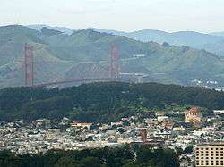
San Francisco's Richmond District in foreground, with Golden Gate Bridge, Marin Headlands, and the Presidio in background | |
| Nickname(s): The Richmond, Outside Lands, Inner Richmond, Outer Richmond, South Marin | |
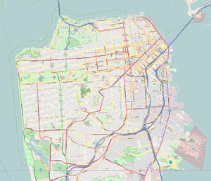 Richmond District Location within San Francisco | |
| Coordinates: 37°46′40″N 122°28′58″W / 37.77778°N 122.48278°WCoordinates: 37°46′40″N 122°28′58″W / 37.77778°N 122.48278°W | |
| Country |
|
| State |
|
| City and county | San Francisco |
| Named for | Richmond, Victoria |
| Government | |
| • Supervisor | Eric Mar |
| • Assemblymember | Phil Ting (D)[1] |
| • State Senator | Scott Wiener (D)[1] |
| • U. S. Repr. | Nancy Pelosi (D)[2] |
| Area | |
| • Total | 7.01 km2 (2.705 sq mi) |
| • Land | 7.01 km2 (2.705 sq mi) |
| Population | |
| • Total | 59,297 |
| • Density | 8,460/km2 (21,920/sq mi) |
| Time zone | Pacific (UTC−8) |
| • Summer (DST) | PDT (UTC−7) |
| ZIP codes | 94118, 94121 |
| Area codes | 415/628 |
| [3] | |
The Richmond District is a neighborhood in the northwest corner of San Francisco, California, developed initially in the late 19th century. It is sometimes confused with Richmond, a city 20 miles (32 km) north of San Francisco.
The Richmond is in many ways defined by its relation to the parks; bordered by Golden Gate Park on the south, the Pacific Ocean to the west, and Lincoln Park, Land's End, Mountain Lake Park and the Presidio of San Francisco to the north, bisected by the Presidio Greenbelt and with the Marin Headlands and the Golden Gate Bridge in full and clear view, the neighborhood, which is otherwise a simple but far-reaching grid, has a feeling of being encapsulated by nature. It is thus known as a safe, peaceful, serene, family neighborhood, and one of the city's largest as a whole, both in terms of housing stock and population.
The Richmond is home to a vast affluent Chinese population and its commercial strips on Geary Blvd. and Clement Street are commonly referred to as the second Chinatown and boasts more highly rated Chinese restaurants than Chinatown itself.
The Richmond also has deep Irish and Russian roots and has many Catholic and Orthodox churches.
Name
The district was given its name by Australian immigrant and art dealer George Turner Marsh, one of the neighborhood's earliest residents, who called his home "the Richmond House" after Richmond, a suburb of Melbourne, Australia.[4] In 1917, the district was legally named "Park-Presidio District", chosen to avoid confusion between the district and the city of Richmond right across the bay. In spite of the official change, virtually every San Franciscan continued to use the old name.
Still, the name Park-Presidio remained on the books until January 2009, when newly elected Supervisor Eric Mar introduced legislation that officially renamed the area north of Golden Gate Park and west of Arguello Boulevard the Richmond District.[5]
History
The district, originally an expanse of rolling sand dunes, was developed initially in the late 19th century.[6] Adolph Sutro was one of the first large-scale developers of the area. After purchasing the Cliff House in the early 1880s,[7] he built the Sutro Baths on the western end of the district, near Ocean Beach.
After the 1906 earthquake, development increased with the need to provide replacement housing. The last of the sand dunes and coastal scrub that once dominated the area were built over to create a street car suburb.
The Russian Revolution and subsequent civil war brought many Anti-Communist White Russian, Orthodox Russian refugees and immigrants into the neighborhood. Russian Orthodox Church Outside Russia briefly made its headquarters at Holy Virgin Cathedral on Geary Boulevard.
In the 1950s, and especially after the lifting of the Chinese Exclusion Act in 1965, Chinese immigrants began to replace the ethnic Jewish and Irish-Americans who had dominated the district before World War II. Chinese of birth or descent now make up nearly the half of residents in the Richmond.[3]
Location

Located directly north of Golden Gate Park, "the Richmond" is bounded roughly by Fulton Street to the south, Arguello Boulevard and Laurel Heights to the east, The Presidio, Lincoln Park, and Sea Cliff to the north, and Ocean Beach to the west. The western portion "Outer Richmond" and the eastern portion "Inner Richmond" is divided by a major thoroughfare, Park Presidio Boulevard (California State Route 1).[8] Geary Boulevard is a major east-west thoroughfare that runs through the Richmond and to downtown. Technically, the Farallon Islands, about 30 miles to the west of mainland San Francisco, are also part of the Richmond District.

Segments
The Richmond has been popularly divided into four parts:
- Lake Street[9] is just south of Presidio of San Francisco and north of Inner Richmond. It is an affluent area characterized by its many Victorian/Edwardian mansions. Its boundaries are: the Presidio to the north, Arguello Blvd to the east, California St. to the south, and 25th Ave. to the west. Its name is derived from the neighborhood's northernmost east-west artery.
- The Inner Richmond[10] sits south of Lake Street. Its boundaries are: California St. to the north, Arguello Blvd to the east, Fulton St. to the south, and Park Presidio Blvd. to the west. The hub of northern Inner Richmond is Geary Blvd. and Clement St. which are particularly known for Chinese, Cambodian, Korean, Burmese, and Russian cuisine. The hub of southern Inner Richmond is Balboa St, which is known for Japanese and Korean restaurants. The Inner Richmond is a diverse area with a sizable Chinese and Russian population.
- The Central Richmond[11] is between Inner Richmond (to the east) and Outer Richmond (to the west). It is bounded by Park Presidio Blvd to the east, California St. to the north, Fulton St. to the south, and 32nd Ave. to the west. Its commercial strips are on Geary Blvd. and Clement St. (between 22nd to 28th Ave.). The Central Richmond has a vast Chinese population, centered on Clement St., and houses several top rated Chinese restaurants.
- The Outer Richmond[12] is to the west of the Central Richmond. It is bounded by Clement St. to the north, 32nd Ave. to the east, Fulton St. to the south, and Ocean Beach to the west. It borders the Ocean Beach and the Cliff House, currently operating as a restaurant. Lincoln Manor is a small enclave of larger homes within the Outer Richmond.
Streets
The Richmond District and the neighboring Sunset District (on the south side of Golden Gate Park) are often collectively known as "The Avenues", because a majority of both neighborhoods are spanned by numbered north-south avenues. When the city was originally laid out, the avenues were numbered from 1st to 49th and the east-west streets were lettered A to X. In 1909, to reduce confusion for mail carriers, the east-west streets and 1st Avenue and 49th Avenue were renamed. The east-west streets were named after Spanish explorers in ascending alphabetical order in a southward direction. First Avenue was renamed Arguello Boulevard and 49th Avenue was renamed La Playa Street.[13]
Today, the first numbered avenue is 2nd Avenue, starting one block west of Arguello Boulevard, and the last is 48th Avenue near Ocean Beach. The avenue numbers increase incrementally, with the exception that what would be 13th Avenue is called Funston Avenue named for Frederick Funston, a U.S. Army general, famous for his exploits during the Spanish–American War, the Philippine–American War, and the 1906 earthquake.
Many of the east-west streets are still named after the Spanish Conquistadors, but there are exceptions. The creation of Golden Gate Park took out the streets previously lettered E through G. The former D Street became Fulton, which is the northern boundary of most of the Park.
North of the Park in the Richmond District, the streets are named Anza, Balboa and Cabrillo.
Architecture
The "Marina Style" houses are popular in Central and Outer Richmond. Marina-style uniquely consists of a sun room (a room with windows on three sides), that can only be accessed through a bedroom—essentially a bedroom inside of a bedroom; and the split bathroom where the bathtub and sink is in a separate room from the toilet, which has its own room.
To lure home buyers with promises of big houses but needing to keep prices low, homes were built with large basements (basement is an unusual feature in California because its weather permits shallower foundation) with the intention that the buyers can convert the basements into living space at their own volition. Essentially marketing a house as two stories with the first story (basement) unfinished. This decision would prove to be ingenious as the 20th century evolved, as many of the basements were converted to garages. Some were converted with garages in the front and in-law units in the back.
Parks and recreation
Major parks in the Richmond District include:
- Lincoln Park and Golf Course in the Outer Richmond, also the location of the California Palace of the Legion of Honor art museum.
- The historic Fort Miley Military Reservation on Point Lobos (San Francisco) is now within the Golden Gate National Recreation Area. A portion houses the large San Francisco VA Medical Center.
- Mountain Lake Park, constructed around the recently restored small lake near the Park Presidio entrance to the San Francisco Presidio park. Mountain Lake is the only natural lake in the entire 80,000-acre Golden Gate National Recreation Area, and it feeds the Presidio's Lobos Creek.
- Rochambeau Park is located between 24th and 25th Avenues, with tennis and basketball courts and play structures.
- Sutro Heights Park, the former site of silver magnate Adolph Sutro's estate, is located in the Outer Richmond District above the Cliff House.[14]
Education

The Richmond is home to Katherine Delmar Burke School, an independent girls' school for kindergarten through eighth grade, as well as Kittredge School, a small, independent private elementary school. Additionally, San Francisco Unified School District serves Richmond District. Alamo, Argonne, and Lafayette elementary schools are located in the Outer Richmond, and Sutro, Frank McCoppin and George Peabody are in the Inner Richmond. Presidio Middle School is located in the Outer Richmond District, while Roosevelt serves the Inner Richmond. George Washington High School is located in the district.[15]
The Richmond/Senator Milton Marks Branch and the Anza Branch of the San Francisco Public Library serve the Richmond District.[16][17] In 1930 voters approved a city charter amendment that would increase funding to the library system so a new library could be built. John Reid, Jr., the architect, designed and landscaped the $57,117.29 new library, which was placed on the site of the former Lafayette School. On April 10, 1932 the Anza Library, the 17th municipal library branch, was dedicated. On May 2009 the library system closed the Anza Branch for repairs.[18] A rebuilt library opened on June 18, 2011. Jing Mo Athletic Association lion dancers provided entertainment at the ceremony.[17]
References
- 1 2 "Statewide Database". UC Regents. Retrieved December 29, 2014.
- ↑ "California's 12th Congressional District - Representatives & District Map". Civic Impulse, LLC.
- 1 2 Richmond District from city-data.com
- ↑ "Richmond District — Western Neighborhoods Project". Retrieved 15 October 2013.
- ↑ Lagos, Marisa (January 28, 2009) "Richmond District name has never been official, but that soon may change". San Francisco Chronicle. (Retrieved 1-28-09.)
- ↑ "Social and Architectural History of the Richmond District - Western Neighborhoods Project - San Francisco History". www.outsidelands.org. Retrieved 2015-12-23.
- ↑ Adolph Sutro (1830-1898) Archived August 13, 2004, at the Wayback Machine. from sfmuseum.net (Virtual Museum of the City of San Francisco). Retrieved 2012-10-28..
- ↑ "Richmond District - San Francisco Neighborhood Guides - FriendlyNeighborhoodGuide". www.friendlyneighborhoodguide.com. Retrieved 2015-12-23.
- ↑ "Lake District Real Estate, San Francisco".
- ↑ "San Francisco: Inner Richmond (SF Chronicle)". The San Francisco Chronicle. October 27, 2011.
- ↑ "The Central Richmond neighborhood in San Francisco".
- ↑ "San Francisco: Outer Richmond (SF Chronicle)". The San Francisco Chronicle. October 27, 2011.
- ↑ Street Naming Controversy - 1909 sfhistoryencyclopedia.com
- ↑ "Richmond District is the true heart of San Francisco". The Washington Times. December 2, 2000. Retrieved on July 4, 2011. "Perhaps the Richmond District's bestkept secret is Sutro Heights Park a little gem on the hill high above Cliff House[...]"
- ↑ http://www.sfusd.edu/en/assets/sfusd-staff/enroll/files/all-in-one-school-map-2011-2012.pdf
- ↑ "Richmond". San Francisco Public Library. Retrieved on November 13, 2011.
- 1 2 McDede, Holly. "Written on the Dock of the Bay: June 18, 2011". KALW. June 18, 2011. Retrieved on July 4, 2011. "Library re-opening // Library lovers! Residents of San Francisco's Richmond District! Residents of the world, rejoice! Another library is among us, and it is the reconstructed Anza Branch Library. Come for the re-opening ceremony. Lion dancers from the Jing Mo Athletic Association will be there to bless the building. // DETAILS: Saturday, June 18, 1pm. Anza Branch Library. 741 30th Avenue, San Francisco"
- ↑ "Anza Library History". San Francisco Public Library. Retrieved on July 4, 2011.
External links
![]() Media related to Richmond District, San Francisco at Wikimedia Commons
Media related to Richmond District, San Francisco at Wikimedia Commons
| Downtown | .svg.png) | |
|---|---|---|
| North of Downtown | ||
| Outside Lands | ||
| Western Addition | ||
| Southern | ||
| ||