Richmond, Missouri
| Richmond, Missouri | |
|---|---|
| City | |
|
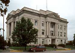
Ray County Courthouse in Richmond | |
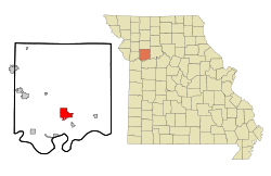 Location of Richmond, Missouri | |
| Coordinates: 39°16′39″N 93°58′33″W / 39.27750°N 93.97583°WCoordinates: 39°16′39″N 93°58′33″W / 39.27750°N 93.97583°W | |
| Country | United States |
| State | Missouri |
| County | Ray |
| Area[1] | |
| • Total | 5.90 sq mi (15.28 km2) |
| • Land | 5.88 sq mi (15.23 km2) |
| • Water | 0.02 sq mi (0.05 km2) |
| Elevation | 823 ft (251 m) |
| Population (2010)[2] | |
| • Total | 5,797 |
| • Estimate (2012[3]) | 5,681 |
| • Density | 985.9/sq mi (380.7/km2) |
| Time zone | Central (CST) (UTC-6) |
| • Summer (DST) | CDT (UTC-5) |
| ZIP code | 64085 |
| Area code(s) | 816 |
| FIPS code | 29-61670[4] |
| GNIS feature ID | 0725280[5] |
| Website | City of Richmond Official Website |
Richmond is a city in Ray County, Missouri, United States. The population was 5,797 at the 2010 census.[6] It is the county seat of Ray County.[7]
History
Richmond was founded in 1827. It was named after Richmond, Virginia.[8]
Geography
Richmond is located at 39°16′39″N 93°58′33″W / 39.27750°N 93.97583°W (39.277550, -93.975907).[9] According to the United States Census Bureau, the city has a total area of 5.90 square miles (15.28 km2), of which, 5.88 square miles (15.23 km2) is land and 0.02 square miles (0.05 km2) is water.[1]
Demographics
| Historical population | |||
|---|---|---|---|
| Census | Pop. | %± | |
| 1860 | 615 | — | |
| 1870 | 1,218 | 98.0% | |
| 1880 | 1,424 | 16.9% | |
| 1890 | 2,895 | 103.3% | |
| 1900 | 3,478 | 20.1% | |
| 1910 | 3,664 | 5.3% | |
| 1920 | 4,409 | 20.3% | |
| 1930 | 4,129 | −6.4% | |
| 1940 | 4,240 | 2.7% | |
| 1950 | 4,299 | 1.4% | |
| 1960 | 4,604 | 7.1% | |
| 1970 | 4,948 | 7.5% | |
| 1980 | 5,499 | 11.1% | |
| 1990 | 5,738 | 4.3% | |
| 2000 | 6,116 | 6.6% | |
| 2010 | 5,797 | −5.2% | |
| Est. 2015 | 5,595 | [10] | −3.5% |
2010 census
As of the census[2] of 2010, there were 5,797 people, 2,430 households, and 1,475 families residing in the city. The population density was 985.9 inhabitants per square mile (380.7/km2). There were 2,777 housing units at an average density of 472.3 per square mile (182.4/km2). The racial makeup of the city was 93.7% White, 3.2% African American, 0.4% Native American, 0.4% Asian, 0.2% Pacific Islander, 0.3% from other races, and 1.9% from two or more races. Hispanic or Latino of any race were 2.1% of the population.
There were 2,430 households of which 30.7% had children under the age of 18 living with them, 42.7% were married couples living together, 13.2% had a female householder with no husband present, 4.8% had a male householder with no wife present, and 39.3% were non-families. 33.9% of all households were made up of individuals and 14.1% had someone living alone who was 65 years of age or older. The average household size was 2.31 and the average family size was 2.93.
The median age in the city was 39.5 years. 23.2% of residents were under the age of 18; 8.8% were between the ages of 18 and 24; 24.1% were from 25 to 44; 25.6% were from 45 to 64; and 18.2% were 65 years of age or older. The gender makeup of the city was 46.5% male and 53.5% female.
2000 census
As of the census[4] of 2000, there were 6,116 people, 2,488 households, and 1,579 families residing in the city. The population density was 1,062.7 people per square mile (410.0/km²). There were 2,651 housing units at an average density of 460.6 per square mile (177.7/km²). The racial makeup of the city was 94.29% White (U.S. Census), 3.73% African American, 3 Native American, 1 Asian, 0.38% from other races, and 1.29% from two or more races. Hispanic or Latino of any race were 1.03% of the population.
There were 2,488 households out of which 33.0% had children under the age of 18 living with them, 47.5% were married couples living together, 12.2% had a female householder with no husband present, and 36.5% were non-families. 32.4% of all households were made up of individuals and 15.9% had someone living alone who was 65 years of age or older. The average household size was 2.40 and the average family size was 3.02.
In the city the population was spread out with 27.2% under the age of 18, 8.3% from 18 to 24, 27.5% from 25 to 44, 19.9% from 45 to 64, and 17.1% who were 65 years of age or older. The median age was 36 years. For every 100 females there were 89.1 males. For every 100 females age 18 and over, there were 81.6 males.
The median income for a household in the city was $33,514, and the median income for a family was $45,186. Males had a median income of $34,500 versus $20,772 for females. The per capita income for the city was $18,021. About 8.1% of families and 10.7% of the population were below the poverty line, including 10.5% of those under age 18 and 12.9% of those age 65 or over.
Arts and culture
Museums
The Ray County History Museum houses both the Ray County Historical Society and the library of the Ray County Genealogy Association.[12][13] The large, two-story red brick building was built in 1910 as the Ray County Poor Farm with separate wings for male and female residents, and is listed on the National Register of Historic Places.[14] The museum's many rooms are filled with themed exhibits displaying artifacts from the Civil War, World War 1, World War 2, Mormon history, and local artifacts illustrating life on historical homesteads.[15] According to local lore, the museum building is a site of suspected paranormal activity.[16]
Visual and performing arts
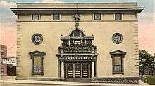
The Farris Theatre, which was designed by the prominent Kansas City architects Shepard and Farrar, and originally opened as the Dougherty Auditorium in 1901, is listed on the National Register of Historic Places.[17] Today it is owned and operated by the Friends of Farris Theatre, Inc, a non-profit that organizes both live performances and showings of digital cinema movies.[18] The theater is located within the Farris Arts District. The Arts District also includes the Hall for Arts Education and the Gallery and Museum for Fine Arts, which are housed in historic buildings originally built for the The Order of Knights of Pythias and Fraternal Order of Eagles.
Parks and recreation
The city has approximately 60 acres of parkland distributed across five public parks.[19] Southview Park is the largest city park with 35.3 acres, and its facilities include a public outdoor swimming pool and a community amphitheater. Cevie Due Park is the site of the city's skate park. The centerpiece of Maurice Roberts park is a decommissioned Lockheed T-33 jet trainer airplane on outdoor display.[20] Hamann Park is the newest park in the system, and is currently under development; plans include a nature walk through the mostly wooded six acre site.
In addition to parks, the city operates a gymnasium. Now part of the city hall complex, it was originally built in 1955 as a gym for the Richmond High School.
Richmond is home to a semi-private 18-hole golf course. The well-regarded course was designed in 1969 by Chet Mendenhall, who was a founding member of the Golf Course Superintendents Association of America (GCSAA).[21]
Education
Primary and secondary schools
Richmond is served by the R-XVI School District.[22] The district operates four public schools: Dear Elementary School, Sunrise Elementary School, Richmond Middle School, and Richmond High School.
Libraries
The Ray County Library was officially formed by voters in 1946, and has been at its present location of 215 East Lexington St since 2004.[23] The facilities include a genealogy room, a community room and a computer training lab.
The Ray County Genealogy Association maintains a library within the Ray County Museum.
Notable people
- Aaron H. Conrow, attorney and Confederate States of America representative during the Civil War
- Alexander William Doniphan, 19th century soldier and political figure who spent his last years in Richmond
- Lenvil Elliott, NFL player for Super Bowl champion San Francisco 49ers
- Robert Ford, the man that shot Jesse James
- Austin Augustus King, Governor of Missouri 1848-1853
- Michael Letzig, professional golfer
- Charles H. Mansur, U.S. congressman and second Comptroller of the Treasury
- Jacob L. Milligan, U.S. congressman
- Maurice M. Milligan, U.S. attorney who successfully prosecuted Kansas City political boss Tom Pendergast in 1939
- John Rooney, radio and television sportscaster
- Forrest Smith, Governor of Missouri 1949-1953
- Beryl Wayne Sprinkel, economist
- John Testrake, Pilot, TWA Flight 847 - hijacked to Beirut June 1985[24][25]
References
- 1 2 "US Gazetteer files 2010". United States Census Bureau. Archived from the original on January 24, 2012. Retrieved 2012-07-08.
- 1 2 "American FactFinder". United States Census Bureau. Retrieved 2012-07-08.
- ↑ "Population Estimates". United States Census Bureau. Archived from the original on June 17, 2013. Retrieved 2013-05-30.
- 1 2 "American FactFinder". United States Census Bureau. Archived from the original on September 11, 2013. Retrieved 2008-01-31.
- ↑ "US Board on Geographic Names". United States Geological Survey. 2007-10-25. Retrieved 2008-01-31.
- ↑ "Race, Hispanic or Latino, Age, and Housing Occupancy: 2010 Census Redistricting Data (Public Law 94-171) Summary File (QT-PL), Richmond city, Missouri". U.S. Census Bureau, American FactFinder 2. Archived from the original on September 11, 2013. Retrieved September 6, 2011.
- ↑ "Find a County". National Association of Counties. Archived from the original on May 31, 2011. Retrieved 2011-06-07.
- ↑ Eaton, David Wolfe (1917). How Missouri Counties, Towns and Streams Were Named. The State Historical Society of Missouri. p. 344.
- ↑ "US Gazetteer files: 2010, 2000, and 1990". United States Census Bureau. 2011-02-12. Retrieved 2011-04-23.
- ↑ "Annual Estimates of the Resident Population for Incorporated Places: April 1, 2010 to July 1, 2015". Retrieved July 2, 2016.
- ↑ "Census of Population and Housing". Census.gov. Archived from the original on May 11, 2015. Retrieved June 4, 2015.
- ↑ "Richmond Chamber of Commerce, Richmond, Missouri - Mushroom Capital of the World". www.richmondchamber.org. Retrieved 2015-12-06.
- ↑ "Ray County". raycountyhistory.webs.com. Retrieved 2015-12-06.
- ↑ "National Register of Historic Places - Nomination Form for Ray County Poor Farm". Ray County National Register Listings. Missouri Department of Natural Resources. 1979-07-10. Retrieved 2015-12-05.
- ↑ Anderson, Wayne; Lee Anderson, Carla (2013). Travels Into Our Past: America's Living History Museums & Historical Sites. Yola. ISBN 9781936688623.
- ↑ "Haunted? Museum rates 3rd in state's spooky spaces". Richmond Daily News. 2010-03-31. Retrieved 2015-12-06.
- ↑ "National Register of Historic Places - Nomination Form for Dougherty Auditorium". Ray County National Register Listings. Missouri Department of Natural Resources. 1982-09-16. Retrieved 2015-11-29.
- ↑ "The Farris Theatre". www.farristheatre.com. Retrieved 2015-11-30.
- ↑ "City of Richmond, Mo. - Mushroom Capital of the World". www.cityofrichmondmo.org. Retrieved 2015-12-13.
- ↑ Emley, Linda (January 2014). "More is known about Maurice Roberts' jet than the park itself". Richmond News. Retrieved 2015-12-12.
- ↑ "Shirkey Golf Course | Richmond, MO". www.shirkeygolfcourse.com. Retrieved 2015-12-13.
- ↑ "Richmond R-XVI School District". www.richmond.k12.mo.us. Retrieved 2016-01-03.
- ↑ "Ray County Library". raycountylibrary.homestead.com. Retrieved 2016-01-03.
- ↑ Jr, Robert Mcg Thomas (1996-02-07). "John Testrake, 68, T.W.A. Pilot Who Became Hero in Hijacking". The New York Times. ISSN 0362-4331. Retrieved 2015-11-29.
- ↑ Emley, Linda (April 2012). "John Testrake showed the world what a real hero is". Richmond News. Retrieved 2015-11-28.
External links
| Wikisource has the text of a 1905 New International Encyclopedia article about Richmond, Missouri. |
- City of Richmond Official Website
- Richmond Area Chamber of Commerce
- Ray County Historical Museum & Research Library
- Historic maps of Richmond in the Sanborn Maps of Missouri Collection at the University of Missouri
Municipalities and communities of Ray County, Missouri, United States | ||
|---|---|---|
| Cities | 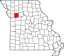 | |
| Villages | ||
| Townships | ||
| CDP | ||
| Other unincorporated communities | ||
| Ghost town |
| |
| Footnotes | ‡This populated place also has portions in an adjacent county or counties | |