Richards Bay
| Richards Bay Cwebeni Richardsbaai | |
|---|---|
|
Richards Bay | |
 Richards Bay  Richards Bay  Richards Bay
| |
| Coordinates: 28°48′00″S 32°06′00″E / 28.80000°S 32.10000°ECoordinates: 28°48′00″S 32°06′00″E / 28.80000°S 32.10000°E | |
| Country | South Africa |
| Province | KwaZulu-Natal |
| District | King Cetshwayo |
| Municipality | uMhlathuze |
| Established | 1969 |
| Area[1] | |
| • Total | 142.78 km2 (55.13 sq mi) |
| Population (2011)[1] | |
| • Total | 57,387 |
| • Density | 400/km2 (1,000/sq mi) |
| Racial makeup (2011)[1] | |
| • Black African | 48.0% |
| • Coloured | 3.2% |
| • Indian/Asian | 18.2% |
| • White | 30.1% |
| • Other | 0.4% |
| First languages (2011)[1] | |
| • Zulu | 40.6% |
| • English | 33.8% |
| • Afrikaans | 21.5% |
| • Other | 4.1% |
| Postal code (street) | 3900 |
| PO box | 3900 |
| Area code | 035 |

Richards Bay (Afrikaans: Richardsbaai) is a town in KwaZulu-Natal, South Africa. It is situated on a 30 square kilometre lagoon of the Mhlatuze River, which gives it one of the country's largest harbours.
History
The town began as a makeshift harbour that was set up by Commodore of the Cape, Sir Frederick Richards during the Anglo-Zulu War of 1879. In 1935 the Richards Bay Game Sanctuary was created to protect the ecology around the lagoon and later by 1943 it expanded into the Richards Bay Park. The town was laid-out on the shores of the lagoon in 1954 and proclaimed a town in 1969. In 1976 Richards Bay harbour was converted into a deep water harbour with railway and an oil/gas pipeline linking the port to Johannesburg.
The South African Government decided in 1965 to build a deepsea harbour at Richards Bay, about 180 kilometres north of Durban. Construction work began in 1972 and four years later, on 1 April 1976, the new harbour was opened. The residential area of Richards Bay developed north of the harbour. Meerensee, started in 1970, was the first suburb. It was followed by Arboretum in 1975 and VeldenVlei in 1980. All three suburbs catered exclusively for Whites in accordance with the existing laws of apartheid. A township for Blacks was developed at Esikhaweni, fifteen kilometres south of Richards Bay. Residential areas for Indians and coloureds were opened after 1985 west of VeldenVlei. All the suburbs of Richards Bay together (excluding the black township of Esikhaweni) had a population of about 20 000 in 1990.
Economy
The Richards Bay Coal Terminal is the largest coal export facility in the world with a planned capacity of 91 million tons per year by the first half of 2009. In 2007 annual throughput was 66.12 million tons.
Two aluminium smelters, Hillside Aluminum and Bayside Aluminium are operated by BHP Billiton. A fertiliser plant operated by Foskor has been erected at the harbour. Iron ore, rutile (titanium oxide) and zircon are mined from the sand dunes close to the lagoon by Richards Bay Minerals. Local exports include coal, aluminium, titanium and other heavy minerals, granite, ferrochrome, paper pulp, woodchips and phosphoric acid. Richards Bay is, alongside Rustenberg, South Africa's fastest-developing city. It is a fast-growing industrial centre that has been able to maintain its ecological diversity.
However, like most of South Africa, the Richards Bay area is plagued by unemployment and poverty. Unemployment has been estimated at forty percent and an undefined number of people live below the poverty line. The local government have made efforts to implement projects aimed at poverty reduction.
The "John Ross Parkway" (P496) which links Richards Bay to Empangeni and the N2 highway is named after "John Ross" (real name, Charles Rawden Maclean), who at the age of 15 walked from Port Natal to Maputo and back to procure medicine and supplies for the early settlers.[2]
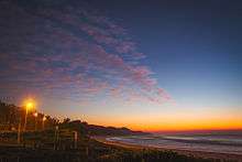
Apart from the mining industry, tourism is a major part of the economy, with Richards Bay seen as a gateway to Zululand, and area popular with foreign tourists because of its large game parks and the diverse wildlife on offer.
The Richards Bay Industrial Development Zone is one of two Industrial Development Zones within the province of KwaZulu-Natal. It is a fully serviced industrial land comprising heavy, medium and light industries linked to adjacent port, Port of Richards Bay.
Government and politics
Since municipal boundaries were newly demarcated in 2000, the Inkatha Freedom Party (IFP), in a coalition with the Democratic Alliance (DA) and other smaller parties, were in power in the uMhlatuze Municipality. However, due to the final floor crossing period, the IFP lost control of the Municipality to the ruling African National Congress (ANC). The Mayor of uMhlathuze is now Mr Elphas Mbatha, whose term will run until at least 2016.
Demographics
White people account for 39.98 percent of the population, followed by Black Africans at 37.05 percent, Asians or Indians at 19.16 percent and Coloureds at 3.8 percent. 74.19 percent of the population is under the age of 34 years, with 2.73 percent over the age of 65. For every 100 females, there are 93 males. The population density has been estimated to be 526-1192 persons/km squared. There are 12,433 households in Richards Bay, with 66.4 percent of such households being house or brick structure. According to household income, the wealthiest suburb is Meerensee, with an average household income of more than R153,601 per annum. The unemployment rate in Richards Bay alone is 19 percent, compared with 55 percent in surrounding rural areas.
The various racial makeups of the 7 different suburbs are still along the Apartheid-era segregation lines, with Meerensee a mostly white area, while suburbs such as Brackenham and Aquadene predominantly Indian/Asian and Ngwelezane home to the Black community. However, in recent years there has been a movement towards more integration, with predominantly Black people moving into other, traditionally higher-income areas, due to the growing Black middle-class in the area.
22 percent of the population have completed school only. A further 8.45 percent have a tertiary education. 16.7 percent have received no schooling at all. However, this data reflects the uMhlathuze municipality as a whole.
Geography and climate
Richards Bay is characterised by a subtropical climate that very closely resempbles a tropical climate as only two months have an average temperature of below 18 °C There are warm wet summers and mild moist to dry winters, which are frost-free. The town has an average annual rainfall of 1228 millimeters (48.3 in). The average annual temperature is 21.5 °C (71 °F), with daytime maxima peaking from January to March at 29 °C (84 °F), and the minimum is 21 °C (70 °F), dropping to daytime highs from June to August of 23 °C (73 °F) and a minimum of 12 °C (53 °F). Sunrise is at 04h45 and sunset at 19h00 in summer. In winter sunrise is at 06h20 and sunset at 17h00. Richards Bay is a popular kitesurfing destination thanks to consistent winds blowing from the North East.
The Richards Bay area is generally very flat and is situated on a coastal plain. The terrain rises slightly towards the west. The suburbs are all no more than a few metres (Reneging around 140m) (feet 459.3 ft) above sea level. The area is abundant in coastal dune forest, most notably along the coastal dune belt and in the suburb of Meerensee.
| Climate data for Richards Bay | |||||||||||||
|---|---|---|---|---|---|---|---|---|---|---|---|---|---|
| Month | Jan | Feb | Mar | Apr | May | Jun | Jul | Aug | Sep | Oct | Nov | Dec | Year |
| Record high °C (°F) | 41 (106) |
39 (102) |
39 (102) |
37 (99) |
35 (95) |
35 (95) |
31 (88) |
37 (99) |
40 (104) |
42 (108) |
43 (109) |
42 (108) |
43 (109) |
| Average high °C (°F) | 29 (84) |
29 (84) |
29 (84) |
27 (81) |
25 (77) |
23 (73) |
23 (73) |
24 (75) |
25 (77) |
25 (77) |
27 (81) |
29 (84) |
26.3 (79.2) |
| Daily mean °C (°F) | 25 (77) |
25 (77) |
24.5 (76.1) |
22.5 (72.5) |
21 (70) |
17.5 (63.5) |
17.5 (63.5) |
19 (66) |
20.5 (68.9) |
21 (70) |
23 (73) |
24.5 (76.1) |
21.75 (71.13) |
| Average low °C (°F) | 21 (70) |
21 (70) |
20 (68) |
18 (64) |
15 (59) |
12 (54) |
12 (54) |
14 (57) |
16 (61) |
17 (63) |
19 (66) |
20 (68) |
17.1 (62.8) |
| Record low °C (°F) | 11 (52) |
13 (55) |
14 (57) |
8 (46) |
7 (45) |
6 (43) |
4 (39) |
5 (41) |
6 (43) |
10 (50) |
11 (52) |
13 (55) |
4 (39) |
| Average precipitation mm (inches) | 172 (6.77) |
167 (6.57) |
107 (4.21) |
109 (4.29) |
109 (4.29) |
57 (2.24) |
60 (2.36) |
65 (2.56) |
77 (3.03) |
105 (4.13) |
114 (4.49) |
86 (3.39) |
1,228 (48.33) |
| Average precipitation days | 12 | 12 | 10 | 8 | 7 | 6 | 6 | 7 | 9 | 12 | 13 | 11 | 113 |
| Source: Weather SA[3] | |||||||||||||
Catholic history of Richards Bay
The parish priest of Kwambonambi celebrated Mass twice a month in a private home and later, from 1973, in the Meerensee Primary School. There were few Catholics in Richards Bay in the beginning, but their number increased steadily with the development of the town. The parish priest of Empangeni took over the pastoral care of these Catholics after a new road link between Empangeni and Richards Bay had been completed at the end of 1974. He introduced a weekly Mass which was held in the Methodist Church in Meerensee and later in the Primary School in Arboretum. The Diocese of Eshowe had in the meanwhile bought a church site in Meerensee. The site was offered to the Nardini Sisters who built a convent and a primary school there in 1977/78. Reg Sommerville, an architect from Empangeni, drew up the plans. O'Connell Brothers, an Empangeni company, began the building operations in June 1977. They finished the first phase within one year so that Archabbot Notker Wolf of St. Ottilien (Germany), who was at that time in South Africa on a visit, could bless the chapel and kindergarten on 12 August 1978. The second phase which involved the construction of a convent, was completed in January 1979. Two Nardini Sisters took up residence in the new convent in February 1979. The convent chapel was used by the Catholic community of Richards Bay for Sunday Mass from June 1978 until August 1986 when the new church in Veld-en-Vlei was opened.
The influx of people to Richards Bay in the early eighties brought about a marked increase in the number of Catholics. This in turn made it necessary to think of building a proper church. Duvenhage and Fischer, architects from Richards Bay, were approached to submit designs. During this planning period, all parishioners were invited to make suggestions for the new Catholic centre. For months the sketches and plans were displayed after Sunday Mass so that everyone could contribute ideas. The Diocese of Eshowe eventually accepted the proposal to build a church together with a hall and a caretaker's flat in Veld en Vlei because of the central position of this suburb. The turning of the sod service took place on 12 September 1985. LTA Construction, one of the largest building companies in South Africa was awarded the contract. Work was completed in June 1986. Bishop Mansuet Biyase consecrated the new church on 31 August 1986. The patron saint of the church and the parish is St. Francis of Assisi. Attached to the church is a sacristy, a small kitchen and a caretaker's flat. In 1992, another building was added. It contains a meeting room and several classrooms for catechism children. The St. Francis Parish in Richards Bay had about 600 Catholics in 1992.
All the additional buildings were constructed and paid for by Father Pious Paul from a legacy left to him. He gave to the Richards Bay parish a memorial for the benefit of all Catholics in Zululand. After Father Pious there were several priests who ran the parish namely Fathers Alousios, Eugene, Hemmie, Peter Blue, Max and the present incumbent Bheki.
Sports Events
2010 Fifa World Cup
Due to its regional airport, its close proximity to Durban (2 hour drive) and its status as the gateway to Zululand, Richards Bay was identified as a possible training base for the World Cup. A small stadium aimed at achieving Fifa accreditation was developed. In late 2009 a Ghana delegation visited the town, raising speculation that the Ghana football team could base themselves in the town. In May 2010 it was announced that the Nigeria football team would move their base to Richards Bay for the duration of the World Cup.
2015 South African Surf Championships
In August 2015 Richards Bay was selected by the governing body of South African Surfing, Surfing South Africa (SSA) to host the South African Surf Championships. Popular surfers from across South Africa to compete at Alkantstrand. The Event was handled and coordinated by local Surf Club, uThungulu Surfriders (formerly ZuluSurfriders Association), and was extremely successful. The Event was covered on the uThungulu Surfriders website with heat by heat updates and daily score, by uThungulu Surfriders correspondent John Cawood (of Alliance Graphics).
Sport
Richards Bay Wrestling Club is one of the top wrestling clubs in the province of Kwa-Zulu Natal.
Famous people
- Lindokuhle "Linda" Mkhwanazi - Soccer player
- Marius Jonker - South African Rugby Union referee
- Bridgitte Hartley - Olympic women's kayak bronze medalist
- Manqoba Mkhize - Former, Bafana Bafana, Amaglug Glug Soccer Player
- Sakho Ngema, Generations actor
- Kyle Abbott - Fast Bowler, South African national cricket team, The Proteas
- Fred Leroux - South African Surfing Masters Champ 2014
Local Media
- The Bay Magazine - a glossy community magazine detailing life in and around Richards Bay
- Bay News Online - an online portal with local news about the area. Driven by community journalism www.baynews.co.zza
Zululand Observer- Locally operated News Paper founded by Mrs Regina Anthony in 1969 - www.zululandobserver.co.za
See also
References
- 1 2 3 4 "Main Place Richards Bay". Census 2011.
- ↑ "John Ross Highway Phase 3 (N2 - Empangeni, KZN)". Acer Africa. 1 July 2009. Retrieved 20 June 2010.
- ↑ South African Weather Service "Richardsbay Stats," Check
|url=value (help). Weather SA. August 2011.
Municipalities and communities of King Cetshwayo District Municipality, KwaZulu-Natal | ||
|---|---|---|
District seat: Richards Bay | ||
| uMhlathuze | .svg.png) | |
| uMlalazi | ||
| Nkandla | ||
| Mbonambi | ||
| Ntambanana | ||
| Mthonjaneni | ||