Rhue (river)
| Rhue | |
|---|---|
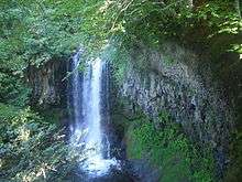 The Rhue at Égliseneuve-d'Entraigues. | |
| Country | France |
| Basin | |
| Main source |
Besse-et-Saint-Anastaise 1,250 m (4,100 ft) 45°29′51″N 02°50′42″E / 45.49750°N 2.84500°E |
| River mouth |
Dordogne 410 m (1,350 ft) 45°22′51″N 02°28′40″E / 45.38083°N 2.47778°ECoordinates: 45°22′51″N 02°28′40″E / 45.38083°N 2.47778°E |
| Progression | Dordogne→ Atlantic Ocean |
| Basin size | 641 km2 (247 sq mi) |
| Physical characteristics | |
| Length | 56.6 km (35.2 mi) |
| Discharge |
|
The Rhue (French: la Rhue, also called Grande Rhue) is a 56.6-kilometre (35.2 mi) long river in the Puy-de-Dôme, Cantal and Corrèze départements, south central France. Its source is at Besse-et-Saint-Anastaise, near Super Besse, in the parc naturel régional des volcans d'Auvergne, 4.5 kilometres (2.8 mi) southeast of the puy de Sancy. It flows generally southwest. It is a left tributary of the Dordogne into which it flows at Bort-les-Orgues.
Its main tributaries are the Santoire, the petite Rhue and the Tarentaine.
Communes along its course
This list is ordered from source to mouth:
- Puy-de-Dôme: Besse-et-Saint-Anastaise, Picherande, Égliseneuve-d'Entraigues
- Cantal: Chanterelle, Condat, Saint-Amandin, Montboudif, Trémouille, Saint-Étienne-de-Chomeil, Champs-sur-Tarentaine-Marchal, Antignac, Vebret
- Corrèze: Bort-les-Orgues
Notes
- This article is based on the equivalent article from the French Wikipedia, consulted on 6 May 2009.
References
This article is issued from Wikipedia - version of the 6/6/2016. The text is available under the Creative Commons Attribution/Share Alike but additional terms may apply for the media files.