Upper Rhine Plain
The Upper Rhine Plain,[1] Rhine Rift Valley[2] or Upper Rhine Graben[3] (German: Oberrheinische Tiefebene, Oberrheinisches Tiefland or Oberrheingraben, French: Vallée du Rhin) is a major rift, about 350-kilometre-long (220 mi) and on average 50-kilometre-wide (31 mi), between Basel in the south and the cities of Frankfurt/Wiesbaden in the north. Its southern section straddles the border between France and Germany. It forms part of the European Cenozoic Rift System, which extends across central Europe. The Upper Rhine Graben formed during the Oligocene as a response to the evolution of the Alps to the south and remains active to the present day. Today, the Rhine Rift Valley forms a downfaulted trough through which the River Rhine flows.

Formation

The Upper Rhine Plain was formed during the Early Cenozoic era, during the Late Eocene epoch. At this time, the Alpine Orogeny, the major mountain building event that was to produce the Alps, was in its early stages. The Alps were formed because the continents of Europe and Africa collided. It is thought that because the collision was irregular, the initial contact between the two continents resulted in the formation of dilational (extensional) structures in the foreland basin to the north of the Alps.[4] The result was substantial crustal thinning, forming a major extensional graben and causing isolated volcanic activity. The stretch factor is estimated to be ~2.
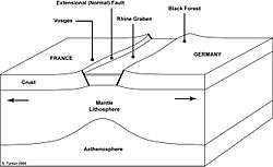
Rift flank uplift
To both the east and west of the Rhine Plain, two major hill ranges have formed that run the length of the basin. To the west, in France, these hills are known as the Vosges mountain range and in the east, in Germany, the hills comprise the Black Forest. These ranges exhume the same types of rocks in their cores, including deep crustal gneiss. Both ranges correspond to uplifts of more than 2,500 metres, much of which has since been eroded. This uplift has occurred because of the isostatic response associated with the formation of an extensional basin. As a consequence, the highest mountains exist immediately adjacent to the margin of the basin, and become increasingly low outwards. The boundaries between the hill ranges and the Rhine Graben are defined by major, normal fault zones.
The northern section of the Rhine Plain is equally framed by somewhat lower mountain ranges, the Palatinate Forest on the western and the Odenwald on the eastern side.
Volcanic activity

The extension induced by the formation of the Alps was sufficient to thin the crust and provide suitable dilational conduits for magmatic and volcanic activity to occur. This resulted in the emplacement of mafic dykes, which follow the general structural trend of the extensional faults. In addition, isolated volcanoes such as the Kaiserstuhl were formed.
The Kaiserstuhl volcano
The Kaiserstuhl (literally "Emperor's Chair") is a cluster of volcanic hills to the northwest of Freiburg, within the Rhine Graben. The highest point of this small, isolated volcanic centre is the Totenkopf (557 metres). Volcanic activity was most prevalent in the Miocene epoch, some 15 million years ago.[5] Today, the Kaiserstuhl volcano is extinct.
Seismic activity
In 1356, the Basel earthquake occurred in the Rhine Plain. It was perhaps the most destructive earthquake ever to have occurred in northwest Europe, destroying the city of Basel and flattening buildings as far as 200 km away. The epicentre of the most significant historic seismological event to have occurred in Central Europe, was located between Waldkirch and St. Peter in Breisgau-Hochschwarzwald. However, it remains disputed whether the fault that ruptured to cause this earthquake was indeed part of the Rhine Valley extensional system, or simply one of the many thrust faults that make up the Alps to the south. Doubts have been raised over the adequacy of the seismic evaluation and design of the Fessenheim Nuclear Power Plant, built in the Rhine Plain close to the faults.[6]
Upper Rhine aquifer
Located below the plain, the Upper Rhine aquifer - one of the largest in Europe - holds an estimated 450,000 km3 (110,000 cu mi) of fresh water and supplies some 3 million people in France and Germany, supplying 75% of their drinking water and 50% of the water used by industry.[7] Since the 1970s it has suffered increasingly serious pollution from nitrates, pesticides, chloride and VOCs.[7]
Research
A collaboration of 25 universities and government agencies have been researching seismic hazards, neotectonics, and water management of the Quaternary Graben fill. The research focuses on four themes :
- "Neotectonics and Seismic Hazard (Identification of zones of on-going deformation. Present stress regime. Earthquake location & frequency. Hazard assessment.)"
- "Modeling of Hydro systems (Modeling of Plio-Quaternary hydro systems of the Upper Rhine Graben and of transfer time of pollutants within them)"
- "Structure and Evolution (Reassessment of structural evolution of the Upper Rhine Graben and implications for its neotectonic deformation; Fault reactivation, crustal rheology and earthquake activity)"
- "Dynamic Modeling (Multi scale dynamic modeling of the past and present deformation of the Rhine Graben area)"
See also
References
- ↑ Dickinson, Robert E. (1964). Germany: A regional and economic geography (2nd ed.). London: Methuen. ASIN B000IOFSEQ.
- ↑ Elkins, T. H. (1972). Germany (3rd ed.). London: Chatto & Windus. ASIN B0011Z9KJA. ISBN 0-7010-0087-2.
- ↑ Dèzes, P.; Schmid S.M.; Ziegler P.A. (2004). "Evolution of the European Cenozoic Rift System: interaction of the Alpine and Pyrenean orogens with their foreland lithosphere" (PDF). Tectonophysics. 389: 1–33. Bibcode:2004Tectp.389....1D. doi:10.1016/j.tecto.2004.06.011. Retrieved June 3, 2010.
- ↑ Sengor, A.M.C. 1976. "Collision of irregular continental margins: Implications for foreland deformation of Alpine-type orogens", Geology, 4, 779-782.
- ↑ Allen, P.A. & Allen, J.R. 2005. Basin Analysis: Principles and Applications (Second Edition). Blackwell Publishing.
- ↑ Centrale Nucléaire de Fessenheim : appréciation du risque sismique RÉSONANCE Ingénieurs-Conseils SA, published 2007-09-05, accessed 2011-03-30
- 1 2 Assessing the benefits of different groundwater protection levels: results and lessons learnt from a contingent valuation survey in the Upper Rhine valley aquifer, France, S Aulong & JD Rinaudo, IWRA 13th World Water Congress, published 2008-01-09, accessed 2011-04-13
External links
| Canada | |
|---|---|
| United States |
|
| Mexico | |
| South America | |
| Australia | |
| Africa | |
| Middle-East | |
| Europe | |
| Related articles | |
| |
Coordinates: 48°57′54″N 8°14′02″E / 48.9650°N 8.2340°E