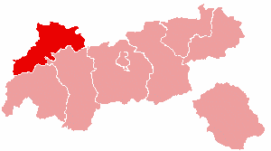
Reutte District
| Bezirk Reutte | |
|---|---|
| District | |
 | |
| Country | Austria |
| State | Tyrol |
| Number of municipalities | 37 |
| Area | |
| • Total | 1,236.37 km2 (477.37 sq mi) |
| Population (2012) | |
| • Total | 31,758 |
| • Density | 26/km2 (67/sq mi) |
| Time zone | CET (UTC+1) |
| • Summer (DST) | CEST (UTC+2) |
The Bezirk Reutte is an administrative district (Bezirk) in Tyrol, Austria. It borders Bavaria (Germany) in the north, the districts Imst and Landeck in the south, and Bregenz and Bludenz (both Vorarlberg) in the west.
Area of the district is 1,236.37 km², with a population of 31,758 (January 1, 2012), and population density of 26 persons per km². Administrative center is Reutte.
Geography
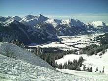
The district comprises the valleys of the Lech, the Tannheimer Tal, and the socalled Zwischentoren between Reutte and Fern Pass. Mountain ranges in the district include parts of the Lechtal Alps, Wetterstein Mountains, Allgäu Alps and Tannheim Mountains. Prominent lakes include Plansee, Heiterwanger See, Haldensee, and Vilsalpsee.
| Historical population | ||
|---|---|---|
| Year | Pop. | ±% |
| 1869 | 17,066 | — |
| 1880 | 16,613 | −2.7% |
| 1890 | 15,949 | −4.0% |
| 1900 | 15,636 | −2.0% |
| 1910 | 16,359 | +4.6% |
| 1923 | 15,827 | −3.3% |
| 1934 | 17,602 | +11.2% |
| 1939 | 17,952 | +2.0% |
| 1951 | 20,901 | +16.4% |
| 1961 | 22,489 | +7.6% |
| 1971 | 26,068 | +15.9% |
| 1981 | 27,370 | +5.0% |
| 1991 | 29,140 | +6.5% |
| 2001 | 31,584 | +8.4% |
| Source: Statistik Austria | ||
Administrative divisions
The 37 municipalities of the district:
- Bach (687)
- Berwang (585)
- Biberwier (632)
- Bichlbach (795)
- Breitenwang (1,532)
- Ehenbichl (810)
- Ehrwald (2,581)
- Elbigenalp (863)
- Elmen (375)
- Forchach (296)
- Grän (580)
- Gramais (54)
- Häselgehr (667)
- Heiterwang (511)
- Hinterhornbach (98)
- Höfen (1,267)
- Holzgau (439)
- Jungholz (308)
- Kaisers (70)
- Lechaschau (2,044)
- Lermoos (1,113)
- Musau (398)
- Namlos (88)
- Nesselwängle (420)
- Pfafflar (125)
- Pflach (1,263)
- Pinswang (416)
- Reutte (6,054)
- Schattwald (427)
- Stanzach (416)
- Steeg (689)
- Tannheim (1,045)
- Vils (1,482)
- Vorderhornbach (261)
- Wängle (848)
- Weißenbach am Lech (1,280)
- Zöblen (239)
| Cities |  | |
|---|---|---|
| Districts | ||
Coordinates: 47°24′N 10°30′E / 47.4°N 10.5°E