Retiro bus station
Retiro Bus Station | |
|---|---|
 | |
| Location |
Av. Antártida Argentina 1175 Retiro, Buenos Aires Argentina |
| Coordinates | 34°35′14″S 58°22′28″W / 34.58722°S 58.37444°W |
| Owned by | Government of Argentina |
| Operated by | Terminal Buenos Aires S.A. |
| Platforms | 75 gates |
| Connections |
Line C (Buenos Aires Metro) at Retiro |
| Construction | |
| Platform levels | 3 |
| Parking | 366 spaces |
| Other information | |
| Website | www.tebasa.com.ar |
| History | |
| Opened | May 1, 1983 |
| Traffic | |
| Passengers | 40,000 (daily) |
.JPG)
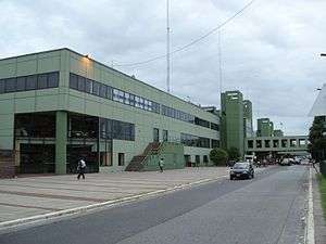
Retiro bus station (Spanish: Terminal de Ómnibus de Retiro) is the main bus terminal in Buenos Aires, Argentina. It is situated in the Retiro district, two blocks north of Retiro railway station.
Overview
The station was commissioned in 1980 by the municipal government under Mayor Osvaldo Cacciatore. Designed by Fernando Serra, Jorge Valera, and Raúl Petrucci, the station was inaugurated in 1983. The station, nearly 400 metres (440 yd) in length, includes 75 gates and is accessible from the parking lot via five elevated walkways. Buses depart from Retiro for all parts of Argentina, and for the neighbouring countries of Uruguay, Brazil, Paraguay, Bolivia and Chile, as well as for Lima, Peru. Buses are operated from the terminal by over 100 Argentine and foreign companies. Other services at the station include gift shops, a bar, numerous fast food concessions, a pharmacy, paramedics, a Bank of the City of Buenos Aires branch, and the Integral parcel service.[1]
The bus station has been operated since 1993 by Teba S.A., a private company. Plans for the relocation of the terminal to the Bajo Flores area (in the west of the city) were announced in 2012; the new terminal is scheduled for completion in 2015. The plan also called for the conversion of the Retiro station into a share taxi (combi) terminal, and the eventual transfer of all long-distance bus traffic to a total of three terminals accessible via subway.[2]
See also
- Transportation in Argentina
- Retiro railway station (Belgrano, Mitre, San Martín)
- Retiro underground station (Line C, Line G, Line H)
References
- ↑ "Servicios al usuario". TEBASA.
- ↑ "Planean reubicar a la terminal de micros de Retiro". InfoBae. 3 June 2012.
External links
- Official website (in Spanish)
![]() Media related to Retiro bus station, Buenos Aires at Wikimedia Commons
Media related to Retiro bus station, Buenos Aires at Wikimedia Commons
Coordinates: 34°35′14″S 58°22′28″W / 34.58722°S 58.37444°W