Republican River
| Republican River | |
| Coster Blanches, Ki-ra-ru-tah, Mahohevaohe[1] | |
 The Republican River near Riverton, Nebraska | |
| Country | United States |
|---|---|
| State | Nebraska, Kansas |
| Tributaries | |
| - left | North Fork Republican River, Frenchman Creek, Red Willow Creek, Medicine Creek |
| - right | Arikaree River, South Fork Republican River, Sappa Creek, Prairie Dog Creek |
| Source confluence | |
| - location | Haigler, Nebraska |
| - elevation | 3,253 ft (992 m) |
| - coordinates | 40°01′12″N 101°56′16″W / 40.02000°N 101.93778°W [1] |
| Mouth | Kansas River |
| - location | Junction City, Kansas |
| - elevation | 1,043 ft (318 m) |
| - coordinates | 39°03′36″N 98°48′05″W / 39.06000°N 98.80139°WCoordinates: 39°03′36″N 98°48′05″W / 39.06000°N 98.80139°W [1] |
| Length | 453 mi (729 km) |
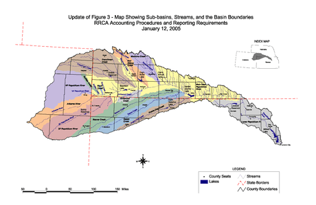
| Basin | 24,900 sq mi (64,491 km2) |
| Discharge | for Junction City about 3 mi (4.8 km) above the mouth[2] |
| - average | 848 cu ft/s (24 m3/s) |
| - max | 33,300 cu ft/s (943 m3/s) |
| - min | 3.2 cu ft/s (0 m3/s) |
| Watersheds | Republican-Kansas-Missouri-Mississippi |
| Reservoirs | Swanson Lake, Harlan County Reservoir, Milford Lake |
The Republican River is a river in the central Great Plains of North America, rising in the High Plains of eastern Colorado and flowing east 453 miles (729 km)[3] through the U.S. states of Nebraska and Kansas.
Geography
The Republican River is formed by the confluence of the North Fork Republican River and the Arikaree River just north of Haigler in Dundy County, Nebraska. It joins with the South Fork Republican River immediately southeast of Benkelman, Nebraska. All three tributaries originate in the High Plains of northeastern Colorado.[4][5][6] From the confluence, the river flows generally eastward along the southern border of Nebraska, passing through Swanson Reservoir and Harlan County Reservoir before curving southward into the Smoky Hills region of Kansas. The Republican River joins the Smoky Hill River at Junction City, Kansas to form the Kansas River.
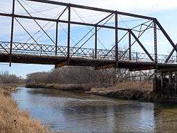
Some cities along the river are McCook, Nebraska, Clay Center, Kansas, Concordia, Kansas and Junction City, Kansas. Near Concordia is the Republican River Pegram Truss, a bridge that goes over the Republican River that is listed on the National Register of Historic Places.
History
The river was named after a branch of Pawnee Indians known as "the Republicans."[7]
Allocation of the water from the Republican River is governed through an agreement called the Republican River Compact, involving the states of Nebraska, Kansas and Colorado, as modified by the settlement[8] of a United States Supreme Court case involving a water-use dispute under the Compact.[9]
Major flooding
July 1902
On July 9, 1902, the river flooded near Concordia, Kansas, breaking a dam and re-routing the river by a quarter-mile (about half a kilometer).[10]
May/June 1935
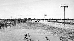
The storm of May 31 and June 1, 1935, (called "Nebraska's Deadliest Flood") dumped an average rainfall of 9 inches (230 mm) on the river's watershed. This storm was also unique in that it moved in the same direction as the drainage basin. As a result, the Frenchman, Red Willow, Medicine, Deer, Muddy, and Turkey creeks all reached their flood peaks at the same time as the crest passed on the Republican River.
According to witness accounts, the roar of the water could be heard coming down the Republican Valley 5 miles (8 km) away. Many survivors also reported that there were two crests - the water came up on May 28, then receded slightly, but the second crest on June 1 greatly exceeded the first. At one point, the water rose 6 feet (1.8 m) in 30 minutes and was 10 to 15 feet (3 to 5 m) higher than the previous record crest. Another account states that the Republican rose 10 feet (3 m) in 12 minutes in McCook, destroying the structures in its path. Water was 20 feet (6 m) deep in some places, and the discharge was 280,000 cubic feet per second (7,900 m3/s), more than 320 times the normal flow today.
Estimates show 113 people killed. From 11,400 to 41,500 head of cattle were killed; one report said that carcasses littering the roads made them impassable. A total of 341 miles (549 km) of highway and 307 bridges were destroyed, and 74,500 acres (301 km2) of farmland were inundated.[11]
See also
| Wikisource has the text of the 1905 New International Encyclopedia article Republican River. |
References
- 1 2 3 "Republican River". Geographic Names Information System. United States Geological Survey. Retrieved 2011-02-01.
- ↑ "USGS Gage #06857100 on the Republican River at Junction City, KS" (PDF). National Water Information System. U.S. Geological Survey. 1964–2014. Retrieved 2014-01-21.
- ↑ U.S. Geological Survey. National Hydrography Dataset high-resolution flowline data. The National Map, accessed March 25, 2011
- ↑ "North Fork Republican River". Geographic Names Information System. United States Geological Survey. Retrieved 2011-02-01.
- ↑ "South Fork Republican River". Geographic Names Information System. United States Geological Survey. Retrieved 2011-02-01.
- ↑ "Arikaree River". Geographic Names Information System. United States Geological Survey. Retrieved 2011-02-01.
- ↑ Stewart, George R. (1967) Names on the Land. Boston: Houghton Mifflin Company. p. 223.
- ↑ Final Settlement Stipulation, Kansas v. Nebraska (PDF), December 15, 2002, retrieved 2012-08-14
- ↑ Kansas v. Nebraska, 538 U.S. 720 (2003) (per curium order approving settlement).
- ↑ A Proud Past... A Pictorial History of Concordia, Kansas, by Bell, Rachel Lowrey (1998), Marceline, Missouri: D-Books Publishing.
- ↑ Nebraska State Historical Society "Republican Flood of 1935-Nebraska's Deadliest Flood"
External links
| Wikimedia Commons has media related to Republican River. |
- Republican River Compact Compliance, State of Colorado