Rennweg (Zürich)
| <span class="nickname" ">Rennweg | |
 Limmatquai and Quaianlagen in Zürich: Bellevueplatz and Bürkliplatz, Quaibrücke, Münsterbrücke and Münsterhof, and Rathausbrücke–Weinplatz, aerial photography by Eduard Spelterini in the probably mid-1890s. | |
| Type | pedestrian zone |
|---|---|
| Owner | City of Zürich |
| Length | about 260 metres (850 ft) |
| Addresses | Rennweg |
| Location |
Oetebachgasse–Widdergasse–(Weinplatz) Zürich, Switzerland |
| Postal code | 8001 |
| Coordinates | 47°22′26″N 8°32′19″E / 47.3740°N 8.5387°E |
| Construction | |
| Completion | probably around 1200 AD or before |
Rennweg is a medieval main road and is today part of the inner-city pedestrian zone of Zürich, Switzerland. A rennweg was in the medieval German speaking territories a street, where horses were moved.[1] Once, it was one of the nodal points of road and public transportation. Today, as well as the Limmatquai, as well as Augustinergasse, it is a section of the southern extension of the Seeuferanlage promenades that were built between 1881 and 1887.[2] Rennweg is one of the best known visitor attractions of the oldest area of the city of Zürich.
Geography and history
Around the 1st century BC La Tène culture, archaeologists excavated individual and aerial finds of the Celtic-Helvetii oppidum Lindenhof, whose remains were discovered in archaeological campaigns in the years 1989, 1997, 2004 and 2007 on Lindenhof, Münsterhof and Rennweg,[3] and also in the 1900s, but the finds mistakenly were identified as Roman objects. Not yet archaeologically proven but suggested by the historians, as well for the first construction of the today's Münsterbrücke Limmat crossing, the present Weinplatz square was the former civilian harbour of the Celtic-Roman Turicum, and so the term Weinplatz may have kept its ancient meaning wine square.[4]
In the European Middle Ages, it was the main street of the upper town of Zürich, leading from the Rennwegtor gate in the fortifications of Zürich and passing below the Lindenhof hill towards the town hall. The site of the Rennweg gate is at the current junction of the Rennweg with the Bahnhofstrasse, the Bahnhofstrasse itself following the course of the 13th-century Fröschengraben, the inner moat that was enforced by the later built Schanzengraben.
Transportation
The Rennweg respectively former Rennweg–Augustinergasse stop on lines 6, 7, 11 and 13 of the Zürich tram system is some 80 metres (260 ft) further southernly along the Bahnhofstrasse road.
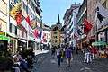 Rennweg towards Glockengasse and Weinplatz
.jpg) Franz Carl Weber store
Franz Carl Weber store.JPG) The medieval Rennweg well
The medieval Rennweg well The Rennweg gate in 1812
References
- ↑ Schweizerisches Idiotikon, vol. VI, col. 840 f., article Ränn-Wëg, and vol. VI, col. 961 sqq., article rännen, esp. meanings 1d («ein Pferd in eilige Bewegung setzen, hetzen») and 2a («mit verhängtem Zügel, in schärfster Gangart reiten, fahren»).
- ↑ "Vom Bürkliplatz zur Sukkulenten-Sammlung" (PDF) (in German). Grün Stadt Zürich. May 2006. Retrieved 2015-01-17.
- ↑ "Aufsehenerregender Keltenfund in Zürich: Die keltische Siedlung am Lindenhof war bedeutender als bisher angenommen" (in German). Neue Zürcher Zeitung NZZ. 2007-10-18. Retrieved 2015-01-13.
- ↑ "Turicum II" (in German). Hochbaudepartement Stadt Zürich. Retrieved 2015-01-13.
External links
| Wikimedia Commons has media related to Rennweg. |