Rendezvous Mountain
| Rendezvous Mountain | |
|---|---|
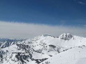 View of Rendezvous Mountain from the top of Rendezvous Bowl at the Jackson Hole Mountain Resort | |
| Highest point | |
| Elevation | 10,450 ft (3,190 m) [1] |
| Prominence | 530 ft (160 m) [1] |
| Coordinates | 43°35′50″N 110°52′14″W / 43.59722°N 110.87056°WCoordinates: 43°35′50″N 110°52′14″W / 43.59722°N 110.87056°W [2] |
| Geography | |
| Location | Teton County, Wyoming, U.S. |
| Parent range | Teton Range |
| Topo map | USGS Teton Village |
| Climbing | |
| Easiest route | Tram |
Rendezvous Mountain is a large mountain massif located in the southern Teton Range in the U.S. state of Wyoming. The highest point on Rendezvous Mountain is Rendezvous Peak (10,927 feet (3,331 m)). The west and northern flanks of the mountain are in Grand Teton National Park, Wyoming, while much of the remainder of the massif is in Bridger-Teton National Forest.[3] The mountain massif extends for a distance of 5 miles (8.0 km) between Granite Canyon to the north and Phillips Canyon to the south. Though there are numerous summits above 10,000 feet (3,000 m), the one that is most commonly visited is the North Peak, where the Jackson Hole Mountain Resort aerial tram provides access to the summit for skiers in the winter and sightseerings and hikers in the summer. The hike down the Rendezvous Mountain Trail to the Granite Canyon Trail has a descent of 4,100 feet (1,200 m) over 12.3 miles (19.8 km).[4]

Cited references
- 1 2 "Rendezvous Mountain, Wyoming". Peakbagger.com. Retrieved 2010-11-28.
- ↑ "Rendezvous Mountain". Geographic Names Information System. United States Geological Survey. Retrieved 2010-11-28.
- ↑ "Rendezvous Peak, WY" (Map). USGS Quad. TopoQuest. Retrieved 2010-11-28.
- ↑ "Day Hikes" (pdf). National Park Service. March 2010. Retrieved 2012-03-03.