Remøy Bridge
| Remøy Bridge Remøybrua | |
|---|---|
|
Remøybrua | |
| Coordinates | 62°21′56.51″N 5°40′11.91″E / 62.3656972°N 5.6699750°ECoordinates: 62°21′56.51″N 5°40′11.91″E / 62.3656972°N 5.6699750°E |
| Carries | Fylkesvei 18 |
| Crosses | Nordre Vaulen |
| Locale | Herøy, Møre og Romsdal, Norway |
| Characteristics | |
| Total length | 340 m (1,120 ft) |
| History | |
| Opened | 1967 |
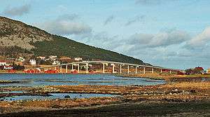
Remøy Bridge (Norwegian: Remøybrua) is a bridge from connecting the islands of Leinøya and Remøya in the municipality of Herøy in Møre og Romsdal county, Norway. The bridge carries the county highway 18 over the Nordre Vaulen strait.[1]
The 340-metre (1,120 ft) long bridge opened in 1967. The bridge is about 3 kilometres (1.9 mi) northeast of Fosnavåg and about 10 kilometres (6.2 mi) northwest of Ulsteinvik. The bridge is part of a network of bridges that connect all the main islands of the municipality of Herøy.
See also
- Runde Bridge
- Herøy Bridge
- Nerlandsøy Bridge
- List of bridges in Norway
- List of bridges in Norway by length
- List of bridges
- List of bridges by length
References
- ↑ "Remøybrua" (in Norwegian). yr.no. Retrieved 2010-09-18.
External links
This article is issued from Wikipedia - version of the 8/23/2013. The text is available under the Creative Commons Attribution/Share Alike but additional terms may apply for the media files.