Rehobeth, Maryland
| Rehobeth, Maryland | |
|---|---|
| Unincorporated community | |
 Rehobeth | |
| Coordinates: 38°02′20″N 75°39′47″W / 38.03889°N 75.66306°WCoordinates: 38°02′20″N 75°39′47″W / 38.03889°N 75.66306°W | |
| Country | United States |
| State | Maryland |
| County | Somerset |
| Elevation | 10 ft (3 m) |
| Time zone | Eastern (EST) (UTC-5) |
| • Summer (DST) | EDT (UTC-4) |
| ZIP code | 21857 |
| Area code(s) | 410, 443, and 667 |
| GNIS feature ID | 591110[1] |
Rehobeth is an unincorporated community in Somerset County, Maryland, United States.[1] It is located at the east end of Old Rehobeth Road, off Rehobeth Road, on the bank of the Pocomoke River. Caldicott, Coventry Parish Ruins, and Rehobeth Presbyterian Church are listed on the National Register of Historic Places.[2]
References
- 1 2 "Rehobeth". Geographic Names Information System. United States Geological Survey.
- ↑ National Park Service (2010-07-09). "National Register Information System". National Register of Historic Places. National Park Service.
Municipalities and communities of Somerset County, Maryland, United States | ||
|---|---|---|
| City | 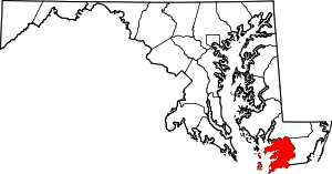 | |
| Town | ||
| CDPs | ||
| Other communities | ||
This article is issued from Wikipedia - version of the 10/28/2016. The text is available under the Creative Commons Attribution/Share Alike but additional terms may apply for the media files.