Registan
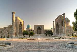
The Registan was the heart of the ancient city of Samarkand of the Timurid dynasty, now in Uzbekistan. The name Rēgistan (ریگستان) means "Sandy place" or "desert" in Persian.
The Registan was a public square, where people gathered to hear royal proclamations, heralded by blasts on enormous copper pipes called dzharchis - and a place of public executions. It is framed by three madrasahs (Islamic schools) of distinctive Islamic architecture.
Madrasahs
The three madrasahs of the Registan are: the Ulugh Beg Madrasah (1417–1420), the Tilya-Kori Madrasah (1646–1660) and the Sher-Dor Madrasah (1619–1636). Madrasah is an Arabic term meaning school.
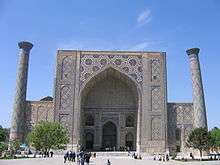
Ulugh Beg Madrasah (1417–1420)
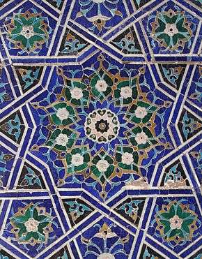
The Ulugh Beg Madrasah , built by Ulugh Beg during the Timurid Empire era of Timur—Tamerlane, has an imposing iwan with a lancet-arch pishtaq or portal facing the square. The corners are flanked by high minarets. The mosaic panel over the iwan's entrance arch is decorated by geometrical stylized ornaments. The square courtyard includes a mosque and lecture rooms, and is fringed by the dormitory cells in which students lived. There are deep galleries along the axes. Originally the Ulugh Beg Madrasah was a two-storied building with four domed darskhonas (lecture rooms) at the corners.
The Ulugh Beg Madrasah (Persian: مدرسه الغ بیگ) was one of the best clergy universities of the Muslim Orient in the 15th Century CE. Abdul-Rahman Jami, the great Persian poet, scholar, mystic, scientist and philosopher studied at the madrasah.[1] Ulugh Beg himself gave lectures there. During Ulugh Beg's government the madrasah was a centre of secular science.
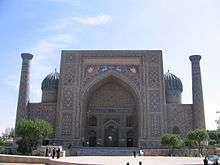
Sher-Dor Madrasah (1619–1636)
In the 17th century the ruler of Samarkand, Yalangtush Bakhodur, ordered the construction of the Sher-Dor (Persian: شیردار) and Tillya-Kori (Persian: طلاکاری) madrasahs. The tiger mosaics on the face of each madrassa are interesting, in that they flout the ban in Islam of the depiction of living beings on religious buildings.
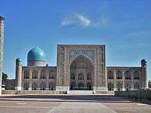
Tilya-Kori Madrasah (1646–1660)
Ten years later the Tilya-Kori (Persian: طلاکاری, meaning "Gilded") Madrasah was built. It was not only a residential college for students, but also played the role of grand masjid (mosque). It has a two-storied main facade and a vast courtyard fringed by dormitory cells, with four galleries along the axes. The mosque building (see picture) is situated in the western section of the courtyard. The main hall of the mosque is abundantly gilded.
Other buildings
Mausoleum of Shaybanids
To the east of the Tilya-Kori Madrasah, the mausoleum of Shaybanids (16th century) is located (see picture). The real founder of Shaybanid power was Muhammad Shaybani - grandson of Abu'l Khair. In 1500, with the backing of the Chaghataite Khanate, then based in Tashkent, Muhammad Shaybani conquered Samarkand and Bukhara from their last Timurid rulers. The founder of the dynasty then turned on his benefactors and in 1503 took Tashkent. He captured Khiva in 1506 and in 1507 he swooped down on Merv (Turkmenistan), eastern Persia, and western Afghanistan. The Shaybanids stopped the advance of the Safavids, who in 1502 had defeated the Akkoyunlu (Iran). Muhammad Shaybani was a leader of nomadic Uzbeks. During the ensuing years they substantially settled down in oases of Central Asia. The Uzbek invasion of the 15th Century CE was the last component of today's Uzbek nation ethnogeny.
Chorsu trading dome
The ancient trading dome Chorsu is situated right behind the Sher-Dor.
Gallery
 Ulugh Beg Madrasah courtyard
_on_the_Sher-dor_madrassa.JPG) Tiger on the Sher-Dor Madrasah iwan
Tiger on the Sher-Dor Madrasah iwan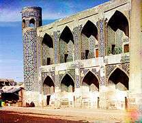 Tilya Kori Madrasah in 19th century
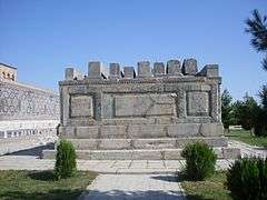 Mausoleum of Shaybanids
 Chorsu trading dome
See also
References
| Architecture |
|  | |||||||||||||||||||||
|---|---|---|---|---|---|---|---|---|---|---|---|---|---|---|---|---|---|---|---|---|---|---|---|
| Arts |
| ||||||||||||||||||||||
| Arts of the book |
| ||||||||||||||||||||||
| Decoration | |||||||||||||||||||||||
| The garden | |||||||||||||||||||||||
| Museums |
| ||||||||||||||||||||||
| Principles, influences | |||||||||||||||||||||||
| Wikimedia Commons has media related to Registan. |
Coordinates: 39°39′17″N 66°58′32″E / 39.65472°N 66.97556°E