Redlingfield
| Redlingfield | |
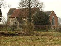 St. Andrew's church, Redlingfield |
|
 Redlingfield |
|
| Population | 144 |
|---|---|
| District | Mid Suffolk |
| Shire county | Suffolk |
| Region | East |
| Country | England |
| Sovereign state | United Kingdom |
| Post town | Eye |
| Postcode district | IP23 |
| Police | Suffolk |
| Fire | Suffolk |
| Ambulance | East of England |
| EU Parliament | East of England |
Coordinates: 52°17′38″N 1°12′22″E / 52.294°N 1.206°E
Redlingfield is a village and civil parish in the Mid Suffolk district of Suffolk in eastern England. Located around six miles south-east of Diss, in 2011 its population (incuding Athelington) was 144, according to the 2011 census.[1] Redlingfield Priory was found here from 1120 until it was disbanded during the Dissolution of the Monasteries, in which "the priory was surrendered on 10 February 1536-7".[2]
Population
From 1851 when it reached its peak population of 251, the parish maintained a relatively constant decline until 1961. Since then, the population has been slowly growing.[3]
St Andrew's Church
The church "serves a small and scattered parish of farms and cottage in the heart of the north Suffolk countryside."[4] The church is Anglo Saxon in origin and is mentioned in the Domesday Book. As is the case with most ancient churches the building has been altered and restored several times. The 'earliest visible craftmanship' dates from the 14th century, the church also served the Redlingfield Priory from 1120 onward, before being returned to the village following the Reformation. One noteworthy feature is that the "church is built almost entirely of red brick, an uncommon and striking site for a church of the age, in this area."[5]
Employment
In 1831, two thirds of the population were described as 'labourers or servants' (with 'Middling Sorts' and Employers & Professionals' combined making up 15 people and 'other' describing 3),[6] 33of the labourers were 'Agricultural Labourers' with the remaining 3 in the category noted as servants. All of the employers were noted as being farmers.[7] The Post Office Directory of 1865 stated 'The land is a rich loam, and is principally the property of Sir Robert Shnfto Adair, who is lord of the manor, but there are a few other landed proprietors, namely, George Barber, Charles Clarke, Thomas Kerry...'[8]
Landscape
The area lies on a Boulder Clay Plateau, rising up to 56m above sea level.[9] The area is relatively flat and is dominated by arable farming although it features one of suffolk's few collections of ancient woodland.[10] The farmlands are divided by hedgerows heading for "stardom" due to their diverse array of species and 3 veteran Oaks believed to be boundary markers, indicating the great age of the hedgerow network.[11]
Second World War
The arrival at of the 3,000 U.S. serviceman of 95th Bomb Group's B-17s at station 119 in neighbouring RAF Horham on June 15, 1943 swamped the corner of Suffolk. The airbase sprawled across four parishes, including Redlingfield and is unfortunately most notable for a B-17 Flying Fortress crashing upon take off into Redlingfield, destroying a farm house and killing all ten crew.[12][13][14]


References
- ↑ "Redlingfield (Parish): Key Figures for 2011 Census: Key Statistics". Neighbourhood Statistics. Office for National Statistics. Retrieved 25 March 2014.
- ↑ Page, William. "A History of the County of Suffolk: Volume 2". Houses of Benedictine nuns: Priory of Redlingfield. Retrieved 25 March 2014.
- ↑ GB Historical GIS / University of Portsmouth, A Vision of Britain through Time. "Redlingfield CP/ExP/AP through time Population Statistics". Total Population. Retrieved 28 April 2014.
- ↑ Ager, Mike. "St Andrew's Church". Retrieved 28 April 2014.
- ↑ Knott, Simon. "St Andrew, Redlingfield". Retrieved 28 April 2014.
- ↑ GB Historical GIS / University of Portsmouth, A Vision of Britain through Time. [URL: http://www.visionofbritain.org.uk/unit/10266701/cube/SOC1831 "Social Structure Statistics"] Check
|url=value (help). Social Status, based on 1831 occupational statistics. Retrieved 28 April 2014. - ↑ A Vision of Britain through Time, GB Historical GIS University of Portsmouth. "Redlingfield CP/ExP/AP through time". Industry Statistics | Males aged 20 & over, in 9 occupational categories. Retrieved 28 April 2014.
- ↑ Wilding, Kevan; Stephen Harris. "History of Suffolk - Redlingfield 1865". Post Office Directory of 1865. Retrieved 28 April 2014.
- ↑ Institute Of National Geological Sciences. "British Geological Survey". The sand and gravel resources of the country around Diss, Norfolk. Retrieved 27 March 2014.
- ↑ Suffolk County Council. "Plateau Claylands" (PDF). Retrieved 27 March 2014.
- ↑ Ager, Mike. "Hedgerow Survey". Retrieved 27 March 2014.
- ↑ Ager, Mike. "The Second World War". Retrieved 27 March 2014.
- ↑ Bomb Group Heritage Association. "The Base and Airfield". Horham Airfield, Station 119.
- ↑ BBC News, Suffolk. "Redlingfield B-17 Flying Fortress crash marked by US relatives". Retrieved 27 March 2014.
External links
| Wikimedia Commons has media related to Redlingfield. |