Red Lake (Romania)
"Killer Lake" redirects here. For the lake in Ontario, see Killer Lake (Ontario).
For Lacu Roșu village in Harghita County, see Gheorgheni.
| Lacul Roșu | |
|---|---|
 | |
| Location | Eastern Carpathians |
| Coordinates | 46°47′22″N 25°47′13″E / 46.78931°N 25.7869°ECoordinates: 46°47′22″N 25°47′13″E / 46.78931°N 25.7869°E |
| Basin countries | Romania |
| Max. length | 8 kilometres (5.0 mi) |
| Max. width | 300 metres (980 ft) |
| Surface area | 11.47 hectares (28.3 acres) |
| Average depth | 9,7 m |
| Max. depth | 12.5 metres (41 ft) |
| Water volume | 587,500 cubic metres (20,750,000 cu ft) |
| Surface elevation | 983 metres (3,225 ft) |
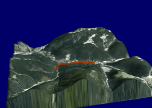
Red Lake 3D
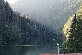
Lacul Roșu (Romanian: Lacul Roșu, Hungarian: Gyilkos-tó – "Killer Lake") is the largest barrier lake, in the Eastern Carpathians chain in Harghita County, Romania. The name of "Lacul Roșu" comes from the reddish alluvia deposited in the lake by the Red Creek. The lake falls within the jurisdiction of the municipality of Gheorgheni.
It was formed in 1837, after a landslide blocked the Bicaz Valley. It is about 93 m deep and covers about 12.01 hectares.[1]

See also
- Bicaz Canyon
- Cheile Bicazului-Hășmaș National Park
References
- ↑ Gheorghe Romanescu, Cristian Constantin Stoleriu and Andrei Enea Limnology of the Red Lake, Romania: An Interdisciplinary Study (2010), p. 47, at Google Books
External links
![]() Media related to Lacul Roşu at Wikimedia Commons
Media related to Lacul Roşu at Wikimedia Commons
This article is issued from Wikipedia - version of the 5/8/2016. The text is available under the Creative Commons Attribution/Share Alike but additional terms may apply for the media files.