Red Hill, Pennsylvania
| Borough of Red Hill | |
| Borough | |
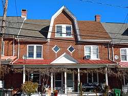 House in the historic district | |
| Country | United States |
|---|---|
| State | Pennsylvania |
| County | Montgomery |
| Elevation | 358 ft (109.1 m) |
| Coordinates | 40°22′35″N 75°29′04″W / 40.37639°N 75.48444°WCoordinates: 40°22′35″N 75°29′04″W / 40.37639°N 75.48444°W |
| Area | 0.7 sq mi (1.8 km2) |
| - land | 0.7 sq mi (2 km2) |
| - water | 0.0 sq mi (0 km2), 0% |
| Population | 2,383 (2010) |
| Density | 3,046.0/sq mi (1,176.1/km2) |
| Government | Council-manager |
| Mayor | David Schiffgens |
| Timezone | EST (UTC-5) |
| - summer (DST) | EDT (UTC-4) |
| ZIP Codes | 18073, 18076 |
| Area code | 215 and 267 |
 Location of Red Hill in Montgomery County | |
 Location of Red Hill in Pennsylvania | |
 Location of Pennsylvania in the United States | |
Red Hill is a borough in Montgomery County, Pennsylvania, United States, and is primarily a lake shore lowlands suburban community northwest of Philadelphia in the Delaware River Valley watershed, as is the balance of its county. The population was 2,383 at the 2010 census.
It is part of the Upper Perkiomen School District.
It is also part of the strip of small towns that run together along Route 29; Red Hill, Pennsburg and East Greenville, colloquially known as 'Red Pennsville'.
History
The Red Hill Historic District was added to the National Register of Historic Places in 1985.[1]
Geography
Red Hill is located at 40°22′35″N 75°29′4″W / 40.37639°N 75.48444°W (40.376288, -75.484308).[2]
According to the United States Census Bureau, the borough has a total area of 0.7 square miles (1.8 km2), all of it land.
Demographics
| Historical population | |||
|---|---|---|---|
| Census | Pop. | %± | |
| 1910 | 664 | — | |
| 1920 | 787 | 18.5% | |
| 1930 | 851 | 8.1% | |
| 1940 | 881 | 3.5% | |
| 1950 | 914 | 3.7% | |
| 1960 | 1,086 | 18.8% | |
| 1970 | 1,201 | 10.6% | |
| 1980 | 1,727 | 43.8% | |
| 1990 | 1,794 | 3.9% | |
| 2000 | 2,196 | 22.4% | |
| 2010 | 2,383 | 8.5% | |
| Est. 2015 | 2,383 | [3] | 0.0% |
| Sources:[4][5][6] | |||
As of the 2010 census, the borough was 96.4% White, 1.4% Black or African American, 0.7% Asian, and 1.3% were two or more races. 2.1% of the population were of Hispanic or Latino ancestry .
As of the census[5] of 2000, there were 2,196 people, 899 households, and 576 families residing in the borough. The population density was 3,046.0 people per square mile (1,177.6/km2). There were 944 housing units at an average density of 1,309.4 per square mile (506.2/km2). The racial makeup of the borough was 97.81% White, 0.32% African American, 0.05% Native American, 0.09% Asian, 0.05% Pacific Islander, 0.32% from other races, and 1.37% from two or more races. Hispanic or Latino of any race were 1.55% of the population.
There were 899 households, out of which 27.7% had children under the age of 18 living with them, 52.5% were married couples living together, 8.1% had a female householder with no husband present, and 35.9% were non-families. 30.1% of all households were made up of individuals, and 19.2% had someone living alone who was 65 years of age or older. The average household size was 2.44 and the average family size was 3.08.
In the borough the population was spread out, with 23.8% under the age of 18, 7.4% from 18 to 24, 28.4% from 25 to 44, 22.4% from 45 to 64, and 18.1% who were 65 years of age or older. The median age was 38 years. For every 100 females there were 91.1 males. For every 100 females age 18 and over, there were 87.2 males.
The median income for a household in the borough was $45,313, and the median income for a family was $58,529. Males had a median income of $35,857 versus $26,295 for females. The per capita income for the borough was $20,633. About 3.1% of families and 4.1% of the population were below the poverty line, including 2.3% of those under age 18 and 10.8% of those age 65 or over.
Politics and government
Red Hill has a city manager form of government with a mayor and borough council.
The borough is part of the Sixth Congressional District (represented by Rep. Ryan Costello), Pennsylvania's 147th Representative District (represented by Rep. Marcy Toepel) and the 24th State Senate District (represented by Sen. Bob Mensch).
| Year | Republican | Democratic |
|---|---|---|
| 2012 | 48.7% 541 | 49.8% 553 |
| 2008 | 41.2% 470 | 56.6% 643 |
| 2004 | 47.9% 491 | 51.2% 525 |
| 2000 | 48.8% 369 | 47.0% 355 |
References
- ↑ National Park Service (2010-07-09). "National Register Information System". National Register of Historic Places. National Park Service.
- ↑ "US Gazetteer files: 2010, 2000, and 1990". United States Census Bureau. 2011-02-12. Retrieved 2011-04-23.
- ↑ "Annual Estimates of the Resident Population for Incorporated Places: April 1, 2010 to July 1, 2015". Retrieved July 2, 2016.
- ↑ "Census of Population and Housing". U.S. Census Bureau. Retrieved 11 December 2013.
- 1 2 "American FactFinder". United States Census Bureau. Retrieved 2008-01-31.
- ↑ "Incorporated Places and Minor Civil Divisions Datasets: Subcounty Resident Population Estimates: April 1, 2010 to July 1, 2012". Population Estimates. U.S. Census Bureau. Retrieved 11 December 2013.