Red Feather Lakes, Colorado
| Red Feather Lakes | |
|---|---|
| Census-designated place (CDP) | |
|
An unusual quartz scepter, from Pennoyer Amethyst Mine, Red Feather Lakes. | |
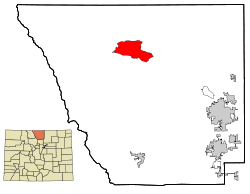 Location of Red Feather Lakes shown within Colorado | |
| Coordinates: 40°48′28″N 105°34′43″W / 40.80778°N 105.57861°W | |
| Country |
|
| State |
|
| County | Larimer County[1] |
| Government | |
| • Type | unincorporated community |
| Area | |
| • Total | 37.2 sq mi (96.4 km2) |
| • Land | 36.7 sq mi (95.0 km2) |
| • Water | 0.6 sq mi (1.4 km2) 1.48% |
| Elevation | 7,890 ft (2,405 m) |
| Population (2000) | |
| • Total | 525 |
| • Density | 14.3/sq mi (5.5/km2) |
| Time zone | MST (UTC-7) |
| • Summer (DST) | MDT (UTC-6) |
| ZIP code[2] | 80545 |
| Area code(s) | 970 |
| FIPS code | 08-63320 |
| GNIS feature ID | 0170220 |

Red Feather Lakes is a census-designated place (CDP) in Larimer County, Colorado, United States. The population was 525 at the 2000 census.[3] The Red Feather Lakes Post Office has the ZIP Code 80545.[2] Located in the Rocky Mountains northwest of Fort Collins, this is a rustic mountain village surrounded by the Roosevelt National Forest. The Red Feather Lakes area offers beautiful scenery, diverse wildlife, hiking trails and cozy mountain retreats.
The community was named after Redfeather, an Indian tribal leader.[4] The area was first settled by loggers and ranchers around 1900, and some deserted homesteads are still strewn throughout the mountain landscape.
Geography
Red Feather Lakes is located at 40°48′28″N 105°34′43″W / 40.80778°N 105.57861°W (40.807820, -105.578641).[5]
According to the United States Census Bureau, the CDP has a total area of 37.2 square miles (96 km2), of which, 36.7 square miles (95 km2) of it is land and 0.6 square miles (1.6 km2) of it (1.48%) is water.
Demographics
As of the census[3] of 2000, there were 525 people, 262 households, and 175 families residing in the CDP. The population density was 14.3 people per square mile (5.5/km²). There were 1,106 housing units at an average density of 30.2 per square mile (11.6/km²). The racial makeup of the CDP was 96.95% White, 0.95% Native American, 0.19% Asian, 0.19% from other races, and 1.71% from two or more races. Hispanic or Latino of any race were 2.29% of the population.
There were 262 households out of which 14.1% had children under the age of 18 living with them, 61.5% were married couples living together, 2.7% had a female householder with no husband present, and 33.2% were non-families. 27.1% of all households were made up of individuals and 10.3% had someone living alone who was 65 years of age or older. The average household size was 2.00 and the average family size was 2.40.
In the CDP the population was spread out with 13.0% under the age of 18, 3.0% from 18 to 24, 18.7% from 25 to 44, 40.4% from 45 to 64, and 25.0% who were 65 years of age or older. The median age was 54 years. For every 100 females there were 97.4 males. For every 100 females age 18 and over, there were 97.0 males.
The median income for a household in the CDP was $33,527, and the median income for a family was $40,714. Males had a median income of $36,250 versus $43,333 for females. The per capita income for the CDP was $19,231. About 3.2% of families and 8.4% of the population were below the poverty line, including 26.7% of those under age 18 and 9.5% of those age 65 or over.
See also
- Outline of Colorado
- State of Colorado
- Red Feather Lakes Community Library
- Shambhala Botanic Gardens
- Shambhala Mountain Center
- The Great Stupa of Dharmakaya
References
- ↑ "US Board on Geographic Names". United States Geological Survey. 2007-10-25. Retrieved 2008-01-31.
- 1 2 "ZIP Code Lookup" (JavaScript/HTML). United States Postal Service. December 14, 2006. Retrieved December 14, 2006.
- 1 2 "American FactFinder". United States Census Bureau. Retrieved 2008-01-31.
- ↑ Dawson, John Frank. Place names in Colorado: why 700 communities were so named, 150 of Spanish or Indian origin. Denver, CO: The J. Frank Dawson Publishing Co. p. 43.
- ↑ "US Gazetteer files: 2010, 2000, and 1990". United States Census Bureau. 2011-02-12. Retrieved 2011-04-23.
| Wikimedia Commons has media related to Pennoyer Amethyst Mine. |
Municipalities and communities of Larimer County, Colorado, United States | ||
|---|---|---|
| Cities | 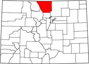 | |
| Towns | ||
| CDPs | ||
| Unincorporated communities | ||
| Ghost towns | ||
| Footnotes | ‡This populated place also has portions in an adjacent county or counties | |
Coordinates: 40°48′28″N 105°34′43″W / 40.80782°N 105.578641°W