Reclamation of Wellington Harbour

The reclamation of Wellington Harbour started in the 1850s, originally to increase the amount of usable flat land for Wellington city. Reclamations in the 1960s and 1970s were to meet the needs of container shipping (containerisation) and new cargo handling methods.[1] Reclamation has added more than 155 hectares to Wellington.[2]
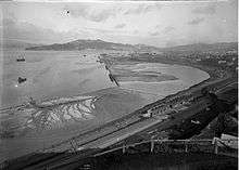
Location of Wellington

A plan for the New Zealand Company's new settlement of Britannia at Pito-one (Petone) had been prepared in England by Samuel Cobham.[3] The key elements of his city were a large amount of flat land on the shores of a harbour, traversable by a navigable river. When surveyors arrived in 1840 on the Cuba led by Captain William Mein Smith, it was determined that the Hutt River was not navigable and, due to its tendency to flood, was not appropriate to support a major city.[4] For these reasons the new settlement was relocated to the southern shores of Port Nicholson and renamed Wellington.[5]
Edward Gibbon Wakefield of the New Zealand Company had devised a system of 'packages' of land for colonists of one town acre each. Cobham's Brittania consisted of 1100 1-acre (4,000 m2) town sections, which William Mein Smith struggled to fit into the new location. These sections were squeezed into the available space by sacrificing many of the planned amenities such as parks, reserves, ports, libraries and many other public areas identified in the original plan.[6] For this reason, from Wellington's outset, there was a need for extra land.
19th-century reclamations and the establishment of the Wellington Harbour Board


While large scale reclamation began in the 1850s, the earliest reclamations in Wellington were conducted by private citizens. A popular story of the first reclamation conducted in Wellington was that done by George Bennet.[7] Bennet had arrived in 1848 on the Berenicia and purchased a hilly section at Windy, or Clay Point (what is now the corner of Lambton Quay and Willis Street). At that time, Windy Point was a precipice with a narrow and often impassible path connecting Willis Street to Beach Road (now Lambton Quay). Bennet commenced, to the amusement of neighbours, with pick-axe, shovel and barrow to move earth from the Point, tossing the spoil onto the path and into the harbour, thus widened the track and performing Wellington's first reclamation.[8]
A programme of systematic reclamation began in 1852, overseen by the provincial government. Charles Carter completed a 360' x 100' extension below Willis Street at a cost of £1,036.[9]
In 1855, the magnitude 8.2 Wairarapa earthquake uplifted the northwestern side of Wellington bay (in some places up to 1.5 metres[10]). This created a tidal swamp, and rendered many of the existing jetties in the harbour unusable. Most of this land was subsequently reclaimed, providing an excellent new rail and road route to the north. Another result of the newly raised land in Wellington was that the shipping basin planned for the city was abandoned and the land used for a cricket ground, the Basin Reserve.[11]
The Wellington City Council was inaugurated in 1870, and by the end of the 1870s some 70 acres (280,000 m2) of land had been reclaimed using spoil from the hills behind Lambton Quay and from Wadestown Hill.[12]
In 1880, the Wellington Harbour Board was established to manage and develop the harbour and its facilities.[13] From then reclamation work was divided between the Harbour Board, the Government and the City Council. Among major developments from 1880 to the turn of the century was the reclamation north of Pipitea Point for railways land and south of Queens Wharf to Te Aro by the City Council. This removed the last vestiges of private ownership of the foreshore, putting the waterfront under the control of the Harbour Board.
By the end of the 19th century, the original 1840 shoreline was unrecognisable.
Twentieth century reclamations
From 1900 to 1930 further reclamations were made for railways and Harbour Board purposes. Additional wharves and the seawall at Oriental Bay were built, and the boat harbour at Clyde Quay was constructed.
1960s and container shipping

The final phase of reclamation took place in the 1960s and 1970s. A government report in 1967 recommended the adoption of containerisation and that Wellington should be one of the two New Zealand ports.[14] With containerisation came new roll-on/roll-off cargo handling methods that require more land adjacent to ships' berths. This resulted in the start of an extension to the Aotea Quay reclamation. Reclamation was carried out on both sides of Queens Wharf and the Wellington Harbour Board Container Terminal was created by a large reclamation at Thorndon.
The first container ship berthed on 19 June 1971.[15] The container terminal has 24.3 hectares of back-up space capable of holding 6,284 containers.[16]
Recent history and present day

After the advent of the Port Reform Act in 1988, the Wellington Harbour Board, along with all other harbour boards, ceased to exist after October 1989. Its commercial, property management and recreational functions were split between the Port of Wellington, Lambton Harbour Management and Wellington City Council respectively.
In 1976, the Historic Places Trust placed 14 plaques along the original shoreline.[17] These plaques run from Pipitea Point, along Lambton Quay, through Mercer Street, lower Cuba Street, Wakefield Street to Oriental Parade at the northern corner of Herd Street.
From the New Zealand Electronic Text Centre[18]
| Year/s | Location | Area |
|---|---|---|
| 1852 | Willis Street, Mercer Street, Chew's Lane, Bonds | |
| 1857-63 | Bank of N.Z., corner Willis Street and Lambton Quay (Noah's Ark site), Harris Street to Grey Street | 7 acres (28,000 m2) |
| 1859 | Oddfellows' Hall site | |
| 1864 | Foresters' Lodge site | |
| 1865 | Messrs. Jacob Joseph, between Waring Taylor and Stout Streets and Lambton Quay | total of last three, 2 rods |
| 1866–67 | Panama, Brandon, Johnston and Waring Taylor Streets, pts. Featherston Street and Customhouse Quay | 12 acres (49,000 m2) |
| 1875 | Government Building site | 2 acres (8,100 m2) |
| 1876 | Government (Lambton) railway station and lines, Featherston Street extension, Ballance, Stout, Bunny and Whitmore Streets, Govt. Printing Office and “Shacks” (this was extended to Pipitea Point) | 46 acres (190,000 m2) |
| 1882 | Manawatu (Thorndon) railway station and lines | 29 acres (120,000 m2) |
| 1882 | Railway Wharf | 1 rod |
| 1884 | Davis Street Extension | |
| 1886 | Hunter Street endowment, Customhouse Quay and Hunter Street | 3 rods |
| 1886 | Victoria and Wakefield Streets | 22 acres (89,000 m2) |
| 1889 | Jervois Quay | 17 acres (69,000 m2) |
| 1893 | Harbour Board store, and track for Te Aro railway, Customhouse Quay and Jervois Quay | 1-acre (4,000 m2) |
| 1893–1901 | Waterloo Quay and Glasgow wharves | 3 acres (12,000 m2) |
| 1895 | Council's yards, near Oriental Parade | 1-acre (4,000 m2) |
| 1901–03 | From near Queen's Wharf to the Lyttelton Ferry Wharf, and site of Customhouse | 2.5 acres (10,000 m2) |
| 1901–1914 | Barnet, Cable and Chaffers Street | 18 acres (73,000 m2) |
| 1902–1925 | Clyde Quay widening | 4 acres (16,000 m2) |
| 1904 | Hutt Road locality | |
| 1904–1916 | Waterloo and near Fryatt Quays, Hinemoa and Cornwall Streets | 34 acres (140,000 m2) |
| 1906 | Waterloo Quay completion | 34.5 acres (140,000 m2) |
| 1906 | Oriental Parade and boat shed sites | 1-acre (4,000 m2) |
| 1910–1913 | Davis Street extension, near Cornwall Street | 4 acres (16,000 m2) |
| 1924–1927 | Thorndon Esplanade and Hutt railway lines areas, vested in the Harbour Board and Railway Department | |
References
- ↑ Waterfront Reclamation, Wellington City Council
- ↑ Wellington City Council's Old Shoreline Trail
- ↑ New Zealand History Online
- ↑ An Encyclopedia of New Zealand 1966
- ↑ New Zealand history online
- ↑ Wellington Waterfront Limited
- ↑ Louis E. Ward (1928). "Early Wellington". Whitcombe and Tombs Limited, republished by NZETC.
- ↑ Louis E. Ward (1928). "Early Wellington". Whitcombe and Tombs Limited, republished by NZETC.
- ↑ Wellington Waterfront Limited
- ↑ Christchurch City Libraries
- ↑ Te Ara: Encyclopedia of New Zealand, The 1855 Wairarapa earthquake
- ↑ Wellington Waterfront Limited
- ↑ Wellington Waterfront Limited
- ↑ New Zealand Ship and Marine Society, Wellington Harbour Board
- ↑ New Zealand Ship and Marine Society, Wellington Harbour Board
- ↑ Waterfront Reclamation, Wellington City Council
- ↑ Waterfront Reclamation, Wellington City Council
- ↑ Louis E. Ward (1928). "Early Wediclington". Whitcombe and Tombs Limited, republished by NZETC.
External links
- http://www.wellingtonwaterfront.co.nz/history/waterfront_reclamation/
- http://www.nzetc.org/etexts/Gov06_07Rail/Gov06_07Rail011a.jpg
- http://www.nzetc.org/tm/scholarly/tei-WarEarl-t1-body-d21-d24.html#WarEarl-fig-WarEarl453a
- Wellington City Council's Old Shoreline Trail
- http://www.nzshipmarine.com/history/companies.aspx?id=11
- Wellington Harbour Board Land and Reclamation Act 1883: New Zealand Legislation
- The Original One-acre Sections in the — Town of Wellington, and their Purchasers. New Zealand Electronic Text Centre