Razavi Khorasan Province
| Razavi Khorasan Province استان خراسان رضوی | |
|---|---|
| Province | |
.JPG) | |
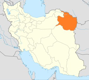 Location of Razavi Khorasan within Iran | |
| Coordinates: 36°17′53″N 59°36′21″E / 36.2980°N 59.6057°ECoordinates: 36°17′53″N 59°36′21″E / 36.2980°N 59.6057°E | |
| Country |
|
| Region | Region 5 |
| Capital | Mashhad |
| Counties | 28 |
| Area | |
| • Total | 118,884 km2 (45,901 sq mi) |
| Population (2011)[1] | |
| • Total | 5,994,402 |
| • Density | 50/km2 (130/sq mi) |
| Time zone | IRST (UTC+03:30) |
| • Summer (DST) | IRST (UTC+04:30) |
| Main language(s) | Persian |
Razavi Khorasan Province (Persian: استان خراسان رضوی, Ostān-e Khorāsān-e Rażavī) is a province located in northeastern Iran. Mashhad is the center and capital of the province. Other cities and counties are Quchan, Dargaz, Chenaran, Sarakhs, Fariman, Torbat-e Heydarieh, Torbat-e Jam, Taybad, Khaf, Roshtkhar, Kashmar, Bardaskan, Nishapur, Sabzevar, Gonabad, Kalat, Khalilabad and Mahvelat. Razavi Khorasan is one of the three provinces that were created after the division of Khorasan Province in 2004. In 2014 it was placed in Region 5[2] with Mashhad as the location of the region's secretariat.
Greater Khorasan has witnessed the rise and fall of many dynasties and governments in its territory throughout history. Various tribes of the Arabs, Turks, Kurds,[3] Turkemen and Mongols brought changes to the region time and time again.
Ancient geographers of Iran divided Iran ("Iran-Shahr") into eight segments of which the most flourishing and largest was the territory of Greater Khorasan. Esfarayen, among other cities of the province, was one of the focal points for residence of the Aryan tribes after entering Iran.
The Parthian empire was based near Merv in Khorasan for many years. During the Sassanid dynasty the province was governed by a Spahbod (Lieutenant General) called "Padgoosban" and four margraves, each commander of one of the four parts of the province.
Khorasan was divided into four parts during the Muslim conquest of Persia, each section being named after the four largest cities, Nishapur, Merv, Herat, and Balkh.
In the year 651, the army of Islamic Arabs invaded Khorasan. The territory remained in the hands of the Abbasid clan until 820, followed by the rule of the Iranian Taherid clan in the year 896 and the Samanid dynasty in 900.
Mahmud of Ghazni conquered Khorasan in 994 and in the year 1037 Tuğrul.
In 1507, Khorasan was occupied by Uzbek tribes. After the death of the Turkic king Nader Shah in 1747, it was occupied by the Afghan Durrani Empire centered in Qandahar.
During the Qajar period, Britain supported the Afghans to protect their East India Company. Herat was thus separated from Persia, and Nasser-al-Din Shah was unable to defeat the British to take back Herat. Finally, the Paris Treaty was concluded in 1903 and Iran was compelled not to challenge the British for Herat and other parts of what is today Afghanistan.
Finally Khorasan was divided into two parts: the eastern part, which was the most densely populated region came under British occupation, and the other western section remained part of Iran.
Khorasan was the largest province of Iran until it was divided into three provinces on September 29, 2004. The provinces approved by the parliament of Iran (on May 18, 2004) and the Council of Guardians (on May 29, 2004) were Razavi Khorasan, North Khorasan, and South Khorasan.
Archaeological sites
Among the archeological sites discovered in this province:
Kohandezh hills
Excavations conducted by an American team between 1935 and 1940 in Nishapur discovered museum-worthy objects, which were shared with the government of the Shah. The Metropolitan Museum of Art's publications document its own Nishapur ceramics from those excavations. For half a century after 1945 the site of Nishapur was ransacked to feed the international market demand for early Islamic works of art. Nowadays, the Kohandezh hills reveal the remains from those excavations.
Shadiyakh
Shadiyakh was an important palace in old Nishapur up to the 7th century, and became more important and populated after that. The palace was completely ruined in the 13th century. It was the home of notables such as Farid al-Din Attar, whose tomb is found in Shadiyakh.
Khorasan today
The major ethnic group in this region are Persians, there are other sizeable communities such as Kurds, Khorasani Turks and Turkmens. There is also an Afghan community in the province due to the influx of Afghan refugees coming from Afghanistan in recent years.
Attractions
This province envelopes many historical and natural attractions, such as mineral water springs, small lakes, recreational areas, caves and protected regions, and various hiking areas.
Besides these, Khorasan encompasses numerous religious buildings and places of pilgrimage, including the shrine of Imam Reza, Goharshad mosque and many other mausoleums and Imamzadehs which attract visitors to this province.
The Cultural Heritage of Iran lists 1179 sites of historical and cultural significance in all three provinces of Khorasan.
Some of the popular attractions of Razavi Khorasan are:
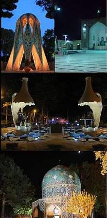
- Tus, where Ferdowsi, the Persian language's most important poet, is buried
- Nishapur, where Farid al-Din Attar, Omar Khayyám, and Kamal-ol-molk are buried
- Goharshad mosque and the vast shrine-complex of Imam Reza that forms the heart of Mashhad
- Khaneh Khorshid
- Shandiz and Torghabeh (famous for their riverside restaurants)
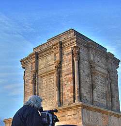
- Tomb of Nadir Shah Afshar in central Mashhad
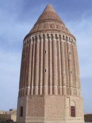
- Akhangan (Akhanjan) tower, north of Tus
- Haruniyeh dome in Tus, where the famous mystic Imam Mohammad Ghazali is buried
- Tus citadel
- Bazangan lake, in Sarakhs district
- Kooh Sangi, a notable hill in Mashhad
- Akhlamad
- Band-e-Golestan (Golestan dam)
- Jaghargh
- Zoshk, a country village west of Mashhad
- Kang, a scenic stepped village
- Noghondar
- Kardeh Dam
- Vakilabad and Mellat parks in Mashhad
- Zari, Hendelabad, Mozdooran, Moghan and Kardeh caves.
- Robat Sharaf (a relatively grand caravanserai ruin in Sarakhs district)
- Tomb of Khajeh Abasalt, Khajeh Morad, Ravi (famous Iranian gnostics) and mausoleum of Sultan Mahmood Ghaznavi
- Yahya and Khajeh Rabi mausoleum at the northern edge of Mashhad city
- Sabz (green) dome in a roundabout in Mashhad
Colleges and universities
- Ferdowsi University of Mashhad (website)
- Mashhad University of Medical Sciences
- Islamic Azad University of Mashhad
- Sabzevar University of Medical Sciences
- Hakim-e Sabzevari University of Sabzevar
- Islamic Azad University of Bardaskan
- Islamic Azad University of Torbat e Jam
- Islamic Azad University of Sabzevar
- Islamic Azad University of Neishabur
- Islamic Azad University of Ghoochan
- Islamic Azad University of Torbat Heidariyeh
- Comprehensive University of Applied and Practical Sciences, Khorasan
- Imam Reza University
- Bahar Institute of Higher Education
- Sadjad Institute of Higher Education
- Asrar Institute of Higher Education
- Payame Noor University of Mashhad
- Payame Noor University of Bardaskan
- Gonabad University of Medical Sciences
- Islamic Azad University of Gonabad
- Sport Sciences Research Institute of Iran
See also
References
- ↑ Selected Findings of National Population and Housing Census 2011
- ↑ "همشهری آنلاین-استانهای کشور به ۵ منطقه تقسیم شدند (Provinces were divided into 5 regions)". Hamshahri Online (in Persian). 22 June 2014 (1 Tir 1393, Jalaali). Archived from the original on 23 June 2014. Check date values in:
|date=(help) - ↑
External links
| Wikimedia Commons has media related to Razavi Khorasan province. |
- The text of the law for division of Khorasan into three provinces (in Persian)
- Cultural Heritage Foundation of Khorasan
- /Razavi Khorasan Province cooprative office
- /Razavi Khorasan Province cooprative office (in Persian)
- Razavi Khorasan Province Department of Education (in Persian)
- Imam Reza Shrine Official website
- Mashad Mayor's Office
- Central Library of Astan Quds Razavi Official website
 |
North Khorasan Province | Ahal Province, |
| |
| Semnan Province | |
|||
| ||||
| | ||||
| Yazd Province | South Khorasan Province | Herat Province, |
| Capital | 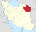 | ||||||||||||||||||||||||||||||||||||||||||||||||||||||||||||||||||||||||||||||
|---|---|---|---|---|---|---|---|---|---|---|---|---|---|---|---|---|---|---|---|---|---|---|---|---|---|---|---|---|---|---|---|---|---|---|---|---|---|---|---|---|---|---|---|---|---|---|---|---|---|---|---|---|---|---|---|---|---|---|---|---|---|---|---|---|---|---|---|---|---|---|---|---|---|---|---|---|---|---|---|
| Counties (A-Q) and cities | |||||||||||||||||||||||||||||||||||||||||||||||||||||||||||||||||||||||||||||||
| Counties (R-Z) and cities | |||||||||||||||||||||||||||||||||||||||||||||||||||||||||||||||||||||||||||||||
| Landmarks |
| ||||||||||||||||||||||||||||||||||||||||||||||||||||||||||||||||||||||||||||||
| populated places | |||||||||||||||||||||||||||||||||||||||||||||||||||||||||||||||||||||||||||||||