Raymore, Missouri
| City of Raymore, Missouri | |
|---|---|
| City | |
| Nickname(s): "The Garden Spot of the State" | |
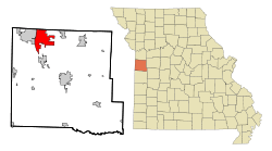 Location in the state of Missouri | |
| Coordinates: 38°48′15″N 94°27′42″W / 38.80417°N 94.46167°WCoordinates: 38°48′15″N 94°27′42″W / 38.80417°N 94.46167°W | |
| Country | United States |
| State | Missouri |
| County | Cass |
| Founded | 1874 |
| Incorporated | 1877 |
| Government | |
| • Mayor | Kris Turnbow |
| • City Council |
Ward 1 Jeffrey Stevens Kevin Kellogg Ward 2 Derek Moorhead* Joseph Burke III Ward 3 Jay Holman Kevin Barber Ward 4 Sonja Abdelgawad Charlene Hubach *mayor pro tempore |
| Area[1] | |
| • Total | 17.75 sq mi (45.97 km2) |
| • Land | 17.58 sq mi (45.53 km2) |
| • Water | 0.17 sq mi (0.44 km2) |
| Elevation | 1,094 ft (333 m) |
| Population (2010)[2] | |
| • Total | 19,206 |
| • Estimate (2013[3]) | 19,754 |
| • Density | 1,092.5/sq mi (421.8/km2) |
| Time zone | CST (UTC-6) |
| • Summer (DST) | CDT (UTC-5) |
| ZIP code | 64083 |
| Area code(s) | 816 |
| FIPS code | 29-60752[4] |
| GNIS feature ID | 0725135[5] |
| Website | http://www.raymore.com |
Raymore is a city in Cass County, Missouri, United States, within the Kansas City Metropolitan Area. Raymore is one of the fastest growing cities in the state of Missouri. The population was 19,206 at the 2010 census.
History
Raymore was platted in 1874.[6] The name Raymore is an algamation of the surnames of two railroad men, Ray and Moore.[7] A post office called Raymore has been in operation since 1872.[8]
The Watkins Family Farm Historic District was listed on the National Register of Historic Places in 2007.[9]
Government
The City of Raymore follows a City Council-Manager style of government. The mayor is Kristofer P. Turnbow. On Sept. 9, 2014, Jim Feuerborn was administered his oath of office to serve as Raymore's City Manager (after previously serving as the City's Acting City Manager since June, and the City's Assistant City Manager prior to that). The Raymore City Hall is located at 100 Municipal Circle, just south of Missouri Route 58.
Geography
Raymore is located at 38°48′15″N 94°27′42″W / 38.80417°N 94.46167°W.[10]
According to the United States Census Bureau, the city has a total area of 17.75 square miles (45.97 km2), of which, 17.58 square miles (45.53 km2) is land and 0.17 square miles (0.44 km2) is water.[1]
Demographics
| Historical population | |||
|---|---|---|---|
| Census | Pop. | %± | |
| 1880 | 83 | — | |
| 1900 | 271 | — | |
| 1910 | 218 | −19.6% | |
| 1920 | 182 | −16.5% | |
| 1930 | 222 | 22.0% | |
| 1940 | 207 | −6.8% | |
| 1950 | 208 | 0.5% | |
| 1960 | 268 | 28.8% | |
| 1970 | 587 | 119.0% | |
| 1980 | 3,154 | 437.3% | |
| 1990 | 5,592 | 77.3% | |
| 2000 | 11,146 | 99.3% | |
| 2010 | 19,206 | 72.3% | |
| Est. 2015 | 20,374 | [11] | 6.1% |
2010 census
As of the census[13] of 2010, there were 19,206 people and 7,001 households residing in the city. The population density was 1115.0 people per square mile (384.4/km²). There were 7,421 housing units at an average density of 418.1 per square mile (384.4/km²). The racial makeup of the city was 87.8% White, 7.8% African American, 0.8% Asian, and 0.4% Native American. Hispanic or Latino of any race were 3.2% of the population.
According to the U.S. Census Bureau's latest data for incorporated cities in Missouri, Raymore's estimated population, as of July 1, 2013, is 19,754 residents.
There were 7,001 households of which 37.9% had children under the age of 18 living with them, 62.6% were married couples living together, 9.9% had a female householder with no husband present, and 24.2% were non-families. 21.1% of all households were made up of individuals and 10.0% had someone living alone who was 65 years of age or older. The average household size was 2.72 and the average family size was 3.10.
In the city the population was spread out with 30.8% under the age of 20, 4.1% from 20 to 24, 27.6% from 25 to 44, 23.8% from 45 to 64, and 13.7% who were 65 years of age or older. The median age was 36.5 years. Females comprised 52.1% of the population.
The median income for a household in the city was $74,597, according to the City's Economic Development department.
Education
Raymore is the strongest contributor to the Raymore-Peculiar school districts, which also includes students from the surrounding areas of Lee's Summit, Peculiar, and unincorporated Cass County.
Elementary schools (K–4):
- Raymore
- Shull
- Peculiar
- Timber Creek
- Stonegate
- Creekmoor
Intermediate schools (5–6):
- Eagle Glen
- Bridle Ridge
Middle schools (7–8):
- Raymore-Peculiar East Middle School
Secondary school (9–12):
References
- 1 2 "US Gazetteer files 2010". United States Census Bureau. Retrieved 2012-07-08.
- ↑ "American FactFinder". United States Census Bureau. Retrieved 2012-07-08.
- ↑ "Population Estimates". United States Census Bureau. Retrieved 2013-06-14.
- ↑ "American FactFinder". United States Census Bureau. Retrieved 2008-01-31.
- ↑ "US Board on Geographic Names". United States Geological Survey. 2007-10-25. Retrieved 2008-01-31.
- ↑ "Cass County Place Names, 1928–1945 (archived)". The State Historical Society of Missouri. Retrieved 17 September 2016.
- ↑ Eaton, David Wolfe (1916). How Missouri Counties, Towns and Streams Were Named. The State Historical Society of Missouri. p. 272.
- ↑ "Post Offices". Jim Forte Postal History. Retrieved 17 September 2016.
- ↑ National Park Service (2010-07-09). "National Register Information System". National Register of Historic Places. National Park Service.
- ↑ "US Gazetteer files: 2010, 2000, and 1990". United States Census Bureau. 2011-02-12. Retrieved 2011-04-23.
- ↑ "Annual Estimates of the Resident Population for Incorporated Places: April 1, 2010 to July 1, 2015". Retrieved July 2, 2016.
- ↑ "Census of Population and Housing". Census.gov. Retrieved June 4, 2015.
- ↑ http://factfinder2.census.gov/main.html
External links
- City of Raymore
- Stonegate of the Good Ranch HOA
- Silver Lake Homes Association
- Creekmoor, a Cooper Community
Municipalities and communities of Cass County, Missouri, United States | ||
|---|---|---|
| Cities | 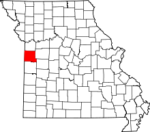 | |
| Villages | ||
| Townships | ||
| Unincorporated communities | ||
| Ghost towns | ||
| Footnotes | ‡This populated place also has portions in an adjacent county or counties | |
Kansas City metropolitan area's cities and counties | ||
|---|---|---|
| Central city | 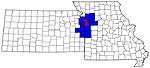 | |
| Largest cities (over 100,000 in 2000) | ||
| Medium-sized cities (10,000 to 100,000 in 2000) | ||
| Smaller Cities (between 5,000 and 9,900 in 2010) | ||
| Counties | ||