Raymer, Colorado
| Town of Raymer, Colorado | |
|---|---|
| Town | |
|
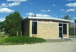
The New Raymer Post Office in the Town of Raymer, Colorado | |
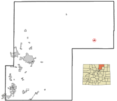 Location of Raymer shown within Colorado | |
| Coordinates: 40°36′31″N 103°50′35″W / 40.60861°N 103.84306°WCoordinates: 40°36′31″N 103°50′35″W / 40.60861°N 103.84306°W | |
| Country |
|
| State |
|
| County[1] | Weld County |
| Incorporated | 1919 |
| Government | |
| • Type | Statutory Town[1] |
| Area | |
| • Total | 0.7 sq mi (1.8 km2) |
| • Land | 0.7 sq mi (1.8 km2) |
| • Water | 0.0 sq mi (0.0 km2) 0.0% |
| Elevation[2] | 4,777 ft (1,456 m) |
| Population (2000) | |
| • Total | 91 |
| • Density | 128.5/sq mi (49.5/km2) |
| Time zone | MST (UTC-7) |
| • Summer (DST) | MDT (UTC-6) |
| ZIP code[3] | New Raymer 80742 |
| Area code(s) | 970 |
| FIPS code | 08-63045 |
| GNIS feature ID | 0182778 |
The Town of Raymer is a Statutory Town located in Weld County, Colorado, United States. The population was 91 at the U.S. Census 2000.
The community has two official names:
- Raymer - The legal name of the incorporated Town of Raymer.
- New Raymer - The official United States Postal Service designation.
Raymer hosts a Minuteman Missile launch site from Warren Air Force Base.[4]
History
The Chicago, Burlington and Quincy Railroad platted the Raymer townsite in Weld County in 1888.[5] The town was named for George Raymer, an assistant chief engineer for the railroad.[5] The Raymer Post Office opened on June 27, 1888.[6] The town flourished for a while, but families eventually moved away and the Post Office closed on May 14, 1895.[6]
The town was given a second life when it was replatted in 1909.[5] On November 13, 1909, the United States Post Office Department open a new post office named New Raymer to distinguish it from the old Raymer post office.[6] The town was incorporated in 1919 under its original name as the Town of Raymer.[5]
The State of Colorado uses the name Raymer for the town, but the United States Postal Service uses the name New Raymer (ZIP code 80742) and refuses to accept the name Raymer for postal delivery.[3] Either name may appear on maps or in gazetteers.
Geography

Raymer (New Raymer) is located at 40°36′31″N 103°50′35″W / 40.60861°N 103.84306°W (40.608649, -103.842963).[7]
According to the United States Census Bureau, the town has a total area of 0.7 square miles (1.8 km2), all of it land.
Demographics
| Historical population | |||
|---|---|---|---|
| Census | Pop. | %± | |
| 1920 | 267 | — | |
| 1930 | 254 | −4.9% | |
| 1940 | 169 | −33.5% | |
| 1950 | 130 | −23.1% | |
| 1960 | 91 | −30.0% | |
| 1970 | 68 | −25.3% | |
| 1980 | 80 | 17.6% | |
| 1990 | 98 | 22.5% | |
| 2000 | 91 | −7.1% | |
| 2010 | 96 | 5.5% | |
| Est. 2015 | 102 | [8] | 6.3% |
At the U.S. Census 2000,[10] there were 91 people, 37 households, and 26 families residing in the town. The population density was 128.5 people per square mile (49.5/km²). There were 48 housing units at an average density of 67.8 per square mile (26.1/km²). The racial makeup of the town was 98.90% White, 1.10% from other races. Hispanic or Latino of any race were 7.69% of the population.
There were 37 households out of which 27.0% had children under the age of 18 living with them, 54.1% were married couples living together, 10.8% had a female householder with no husband present, and 29.7% were non-families. 24.3% of all households were made up of individuals and 5.4% had someone living alone who was 65 years of age or older. The average household size was 2.46 and the average family size was 2.92.
In the town the population was spread out with 28.6% under the age of 18, 7.7% from 18 to 24, 20.9% from 25 to 44, 24.2% from 45 to 64, and 18.7% who were 65 years of age or older. The median age was 38 years. For every 100 females there were 116.7 males. For every 100 females age 18 and over, there were 103.1 males.
The median income for a household in the town was $26,250, and the median income for a family was $36,875. Males had a median income of $29,583 versus $21,875 for females. The per capita income for the town was $8,470. There were 14.8% of families and 18.8% of the population living below the poverty line, including 11.6% of under eighteens and 40.0% of those over 64.
See also
References
- 1 2 "Active Colorado Municipalities". State of Colorado, Department of Local Affairs. Retrieved 2007-09-01.
- ↑ "US Board on Geographic Names". United States Geological Survey. 2007-10-25. Retrieved 2008-01-31.
- 1 2 "ZIP Code Lookup" (JavaScript/HTML). United States Postal Service. December 8, 2006. Retrieved December 8, 2006.
- ↑ CO0475
- 1 2 3 4 Eichler, Geo. R. (1977). Colorado Place Names. 77-089726: Johnson Publishing Company. pp. 59–60.
- 1 2 3 Bauer, William H.; James L. Ozment; John H. Willard (1990). Colorado Post Offices 1859-1989. 90-34759: The Colorado Railroad Museum. pp. 105, 120. ISBN 0-918654-42-4.
- ↑ "US Gazetteer files: 2010, 2000, and 1990". United States Census Bureau. 2011-02-12. Retrieved 2011-04-23.
- ↑ "Annual Estimates of the Resident Population for Incorporated Places: April 1, 2010 to July 1, 2015". Retrieved July 2, 2016.
- ↑ "Census of Population and Housing". Census.gov. Retrieved June 4, 2015.
- ↑ "American FactFinder". United States Census Bureau. Retrieved 2008-01-31.
External links
Municipalities and communities of Weld County, Colorado, United States | ||
|---|---|---|
| Cities | 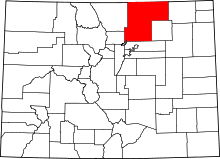 | |
| Towns | ||
| CDP | ||
| Unincorporated communities | ||
| Ghost towns | ||
| Footnotes | ‡This populated place also has portions in an adjacent county or counties | |
